


Click Image to Enlarge
Ohio Counties
There is eighty-eight counties in the state of Ohio. Washington County the oldest in the state established on July 27, 1788. Noble County was formed on March 11, 1851 from portions of Guernsey, Morgan, Monroe and Washington counties. It was the last county to be formed in Ohio and, therefore, represents the youngest county in the state.Clinton County, Ohio
Clinton County Education, Geography, and History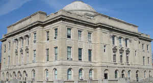
Clinton County is a county located in the state of Ohio. Based on the 2010 census, the population was 42,040. The county seat is
Wilmington. The county is named for former US Vice President George Clinton.
Clinton County comprises the Wilmington, Ohio Micropolitan Statistical Area, which is also included in the Cincinnati-Wilmington-Maysville,
OH-KY-IN Combined Statistical Area.
Etymology - Origin of Clinton County Name
The county took its name from George Clinton, the Vice-President of the United States in 1810.
Demographics:
County QuickFacts: CensusBureau Quick Facts
Clinton County History
On February 19, 1810, the Ohio government authorized the creation of Clinton County. The county took its name from George Clinton, the Vice-President of the United States in 1810. Many of the county's early residents were members of the Society of Friends (Quakers). They played an important role
in the Underground Railroad during the 1830s, 1840s, 1850s, and 1860s, helping runaway slaves find freedom in the North. The Quakers also established Wilmington College during the 1870s.
Clinton County is located in southwestern Ohio. The county is primarily rural, with just over one percent of its 411 square miles deemed to be urban areas. Wilmington is the largest metropolitan area, with a population of 11,921 people in 2000. It is also the county seat and home to a National
Weather Service station. In 2000, the county's next largest community was Blanchester, with a population of 4,220 people. Unlike many of Ohio's predominantly rural counties, Clinton County experienced more than a fourteen percent growth between 1990 and 2000, raising the county's total population to
40,543 residents. The county averages almost ninety-nine people per square mile.
Most Clinton County residents work in the transportation sector. In this order, manufacturing, sales, service industry, and government positions rank second, third, fourth, and fifth in employment opportunities for Clinton County residents. Agriculture ranks sixth, although the county consists of
some of the most fertile and productive soil in the United States. In 1999, the per capita income was just under twenty-six thousand dollars, with nine percent of the population living in poverty.
Most voters in Clinton County claim to be independents, yet in recent years, they have overwhelmingly supported Republican Party candidates at the national level.
Sources
Clinton County, Ohio History Central, July 23, 2008,
http://www.ohiohistorycentral.org/entry.php?rec=1914&nm=Clinton-County
Geography: Land and Water
As reported by the Census Bureau, the county has a total area of 412 square miles (1,070 km2), of which 409 square miles (1,060 km2) is
land and 3.6 square miles (9.3 km2) (0.9%) is water.
The entire county lies within the Little Miami River watershed, with the exception of extreme eastern areas, which are within the Scioto River
watershed. Clinton County lies within the till plains physiographic region, and is somewhat flat or gently rolling. The northern two thirds of
the county were covered with an ice sheet during the Wisconsinan Stage, while the southern third was covered by ice sheets during the much
older Illinoian Stage. Because of such a history with ice, glacial features are readily found on the landscape, such as moraines and kames.
The general elevation of the county is roughly 1,050 feet (320 m) above sea level, and there are few areas in the county that deviate from
this more than 200 feet (61 m).
Neighboring Counties
Bordering counties are as follows:
- Greene County (north)
- Fayette County (northeast)
- Highland County (southeast)
- Brown County (south)
- Clermont County (southwest)
- Warren County (west)
Education
The following school districts have territory in Clinton County. Those primarily in Clinton are in bold, those primarily in other counties are in italics.
Blanchester Local School District (also in Brown, Clermont, and Warren)
Clinton Massie Local School District (also in Warren)
East Clinton Local (also in Fayette, Greene, and Highland)
Fairfield Local School District (also in Highland)
Fayetteville-Perry Local School District (also in Brown)
Greeneview Local School District (also in Greene)
Lynchburg-Clay Local School District (also in Highland)
Miami Trace Local School District (also in Fayette)
Wilmington City School District (also in Greene)
Xenia City School District (also in Greene and Warren)


Click Image to Enlarge
