


Click Image to Enlarge
Ohio Counties
There is eighty-eight counties in the state of Ohio. Washington County the oldest in the state established on July 27, 1788. Noble County was formed on March 11, 1851 from portions of Guernsey, Morgan, Monroe and Washington counties. It was the last county to be formed in Ohio and, therefore, represents the youngest county in the state.Geauga County, Ohio
Geauga County Education, Geography, and History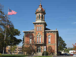
Geauga County is a county located in the state of Ohio. Based on the 2010 census, the population was 93,389. The county seat is Chardon.
The county is named for a Onondaga or Seneca language word meaning 'raccoon', originally the name of the Grand River.
Geauga County is part of the Cleveland-Elyria, OH Metropolitan Statistical Area.
Etymology - Origin of Geauga County Name
The county is named for an Indian word for "raccoon."
Demographics:
County QuickFacts: CensusBureau Quick Facts
Geauga County History
On December 31, 1805, the Ohio government authorized the creation of Geauga County. It originally was a portion of Trumbull County and was part of the Connecticut Western Reserve. The county is named for an Indian word for "raccoon."
Geauga County is located in the northeastern corner of Ohio and covers almost 404 square miles. The county has grown dramatically in recent years, as residents of nearby Cleveland in Cuyahoga County have moved to Geauga and surrounding counties to escape the busyness of the city. Between 1990 and
2000, Geauga County's population increased by 12.1 percent to a total of 90,895 residents in 2000. Chester Township is the largest community in the county, with almost eleven thousand residents in 2000. The county seat of Chardon ranked a distant seventh in size, with just over 5,100 residents in
2000. The county averages 225 residents per square mile.
Geauga County is overwhelmingly rural, but most residents earn their livings by working in manufacturing, sales, or service positions. Farming is a distant fourth, although county residents produce almost all of Ohio's maple syrup or other maple products, earning Geauga the nickname "Ohio's Sweetest
County."Many residents also commute to Cleveland to work. The county's average income was approximately thirty-four thousand dollars per person in 1999, with five percent of the population living in poverty.
Most voters in Geauga County claim to be independents, yet in recent years, they have supported Republican candidates at the national level.
Ohio Governor Seabury Ford ranks among Geauga County's most famous residents.
Sources
Geauga County, Ohio History Central, July 23, 2008,
http://www.ohiohistorycentral.org/entry.php?rec=1932&nm=Geauga-County
Geography: Land and Water
As reported by the Census Bureau, the county has a total area of 408 square miles (1,060 km2), of which 400 square miles (1,000 km2) is
land and 8.1 square miles (21 km2) (2.0%) is water.
The geography of Geauga County was radically changed by Illinoian and Wisconsinan glaciation, which is evident in the deranged drainage
system, landscape change, and glacial till. The headwaters of three watercourses in the Lake Erie basin are located in Geauga County. These
include the Cuyahoga River, Chagrin River, and Grand River. Portions of all three are designated Ohio Scenic Rivers.
Point sources of the east branch of the Cuyahoga River are located in Hambden Township, Claridon Township, and Burton Township,. The point
source of the west branch of the Cuyahoga River is near the intersection of Pond and Rapids Roads in Burton Township.
The point sources of the east branch of the Chagrin River are at Bass Lake in Munson Township and the southwest corner of the City of
Chardon.McFarland Creek in Bainbridge Township, sometimes referred to as Chagrin Falls because of the postal zip code, is a tributary of the
Aurora branch of the Chagrin River.
Point sources of the Grand River are located in Parkman Township, Troy Township, and Swine Creek in Middlefield Township.
While the majority of waterways in Geauga County are part of the Lake Erie watershed, the Silver Creek in Troy Township is a tributary to the
west branch of the Mahoning River, part of the Ohio River watershed, the largest tributary to the Mississippi River. There is another Silver
Creek in Geauga County located in Russell Township, which is a tributary to the east branch of the Chagrin River.
Neighboring Counties
Bordering counties are as follows:
- Lake County (north)
- Ashtabula County (northeast)
- Trumbull County (southeast)
- Portage County (south)
- Cuyahoga County (west)
- Summit County (southwest corner)
Education
Public school districts
Geauga County is home to seven public school districts


Click Image to Enlarge
