


Click Image to Enlarge
Ohio Counties
There is eighty-eight counties in the state of Ohio. Washington County the oldest in the state established on July 27, 1788. Noble County was formed on March 11, 1851 from portions of Guernsey, Morgan, Monroe and Washington counties. It was the last county to be formed in Ohio and, therefore, represents the youngest county in the state.Morrow County, Ohio
Morrow County Education, Geography, and History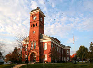
Morrow County is a county located in the state of Ohio. Based on the 2010 census, the population was 34,827. Its county seat is Mount
Gilead. The county was organized in 1848 from parts of four neighboring counties and named for Jeremiah Morrow, Governor of Ohio from 1822 to
1826. Shawnee people used the area for hunting purposes before white settlers arrived in the early 19th century.
Morrow County is included in the Columbus, OH Metropolitan Statistical Area.
Etymology - Origin of Morrow County Name
Residents named the county in honor of Jeremiah Morrow, a previous governor of Ohio.
Demographics:
County QuickFacts: CensusBureau Quick Facts
Morrow County History
On February 24, 1848, the Ohio government authorized the creation of Morrow County. Residents named the county in honor of Jeremiah Morrow, a previous governor of Ohio. Many early settlers were members of the Society of Friends (Quakers), who played an active role in the Underground Railroad.
During World War I, Morrow County residents purchased more Victory bonds than the residents of any other single Ohio county. To honor this achievement, the Victory Shaft Monument was erected in downtown Mount Gilead.
Morrow County is located in the north central portion of Ohio. The county seat is Mount Gilead, which is the largest population center, with almost 3,300 residents in 2000. This marked a fourteen percent growth in the town's population since 1990, and the county, itself, experienced a similar growth
rate, to a total population of 31,628 people, during this same time period. Unlike many of Ohio's more rural counties, which are losing population to the state's larger cities, Morrow County is experiencing tremendous growth. An average of seventy-eight people live in each of Morrow County's 406
square miles.
Despite the tremendous growth, Morrow County remains heavily rural. Farming is the county's largest employer, with approximately sixty-two percent of the county's acreage serving as farm fields. Manufacturing businesses are the county's next largest employer, with government and retail positions
finishing third and fourth respectively. Oil drilling also proved to be a major industry in the county during the 1960s. The county's average income was 17,776 dollars per person in 1999, with 10.1 percent of the population living in poverty.
Most voters in Morrow County claim to be independents, yet in recent years, they have overwhelmingly supported Republican candidates at the national level
Sources
Morrow County, Ohio History Central, July 24, 2008,
http://www.ohiohistorycentral.org/entry.php?rec=1983&nm=Morrow-County
Geography: Land and Water
As reported by the Census Bureau, the county has a total area of 407 square miles (1,050 km2), of which 406 square miles (1,050 km2) is land and 1.1 square miles (2.8 km2) (0.3%) is water. Morrow County is considered to be a part of "Central Ohio."
Neighboring Counties
Bordering counties are as follows:
- Crawford County (north)
- Richland County (northeast)
- Knox County (southeast)
- Delaware County (southwest)
- Marion County (west)
Education


Click Image to Enlarge
