


Click Image to Enlarge
Ohio Counties
There is eighty-eight counties in the state of Ohio. Washington County the oldest in the state established on July 27, 1788. Noble County was formed on March 11, 1851 from portions of Guernsey, Morgan, Monroe and Washington counties. It was the last county to be formed in Ohio and, therefore, represents the youngest county in the state.Tuscarawas County, Ohio
Tuscarawas County Education, Geography, and History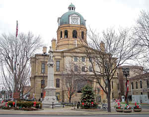
Tuscarawas County is a county located in the eastern part of the state of Ohio. Based on the 2010 census, the population was 92,582. Its
county seat is New Philadelphia. Its name is a Delaware Indian word variously translated as "old town" or "open mouth".
Tuscarawas County comprises the New Philadelphia-Dover, OH Micropolitan Statistical Area, which is also included in the
Cleveland-Akron-Canton, OH Combined Statistical Area.
Etymology - Origin of Tuscarawas County Name
Residents named the county after an Indian word meaning "open mouth."
Demographics:
County QuickFacts: CensusBureau Quick Facts
Tuscarawas County History
On February 13, 1808, the Ohio government authorized the creation of Tuscarawas County. Residents named the county after an Indian word meaning "open mouth."Among the first white residents of the county were Moravian missionaries, who sought to convert members of the Delaware Indians. The
missionaries established the villages of Schoenbrunn and Gnadenhutten to carry out their work in the 1770s. In the early 1800s, German Separatists established the village of Zoar in Tuscarawas County. For numerous years these people lived as a communal society. The Ohio Historical Society now
operates Schoenbrunn and Zoar as historic sites.
Tuscarawas County is located in northeastern Ohio and covers 568 square miles. The county's population increased by 8.1 percent between 1990 and 2000, as residents of Canton, in nearby Stark County, sought to escape the larger city's congestion. Tuscarawas County had a total of 90,914 residents in
2000. New Philadelphia is the county seat and the largest city in the county, with 17,056 residents in 2000. Tuscarawas County averages 160 residents per square mile.
Tuscarawas County is overwhelmingly rural, with only 1.6 percent of the county deemed to be urban, but most residents earn their livings by working in sales, manufacturing, or service positions. Farming ranks a distant fourth. Tuscarawas County's average income was 21,708 dollars per person in 1999,
with 10.2 percent of the population living in poverty.
Most voters in Tuscarawas County claim to be independents, yet in recent years, they have supported Republican Party candidates at the national level.
Baseball great Denton "Cy"Young was born in Tuscarawas County
Sources
Tuscarawas County, Ohio History Central, July 24, 2008,
http://www.ohiohistorycentral.org/entry.php?rec=2020&nm=Tuscarawas-County
Geography: Land and Water
As reported by the Census Bureau, the county has a total area of 571 square miles (1,480 km2), of which 568 square miles (1,470 km2) is land and 3.8 square miles (9.8 km2) (0.7%) is water
Neighboring Counties
Bordering counties are as follows:
- Stark County (north)
- Carroll County (northeast)
- Harrison County (southeast)
- Guernsey County (south)
- Coshocton County (southwest)
- Holmes County (northwest)
Education


Click Image to Enlarge
