


Click Image to Enlarge
Washington Counties
There are thity-nine counties in the state of Washington. Washington was carved out of the western part of Washington Territory and admitted to the Union as the 42nd state in 1889. The first counties were created from unorganized territory in 1845.Benton County, Washington
Benton County Education, Geography, and History
Benton County is a county located in the south-central portion of the state of Washington. Based on the 2010 census, its population was 175,177. The county seat is Prosser, and its largest city is Kennewick. The Columbia River demarcates the north, south, and east boundaries of the county.
Etymology - Origin of Benton County Name
Thomas Hart Benton, a Missouri U. S. senator.
Demographics:
County QuickFacts: CensusBureau Quick Facts
Benton County History
Benton County was created from what were then larger versions of Klickitat County and Yakima County on 8 March 1905. and was named after US Senator from Missouri (1821-1851) and later US Representative (1853-1855) Thomas Hart Benton.
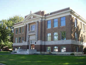
Benton County Historical Museum
The first covered wagons arrived in the Yakima Valley in 1853. A band of friendly Indians, intrigued by the sound of wagon wheels, followed the wagon train into the area. Unfortunately trouble soon began between the Indians and the new arrivals. It became
so serious that Eastern Washington was closed to white settlement. However after a series of uprisings and battles, the ban was lifted. Colonel William Farrand Prosser
It wasn't until 1882 when the greatest influx of homesteaders entered the Yakima Valley in search of land. Colonel Prosser staked a homestead on the banks of the Yakima River in 1882; this site later became the foundation of the future city of Prosser. Prosser was a prominent citizen in the
development of Yakima County, serving as County Auditor in 1886. He also attended the Constitutional Convention held in Olympia on July 4th as one of the 75 delegates charged with writing a Constitution for the new state of Washington.
Prosser, the future county seat of Benton County, was platted in 1884. Two separate settlements, Colonel Prosser's site known as Prosser Falls and Kinneyville, formed the foundation of Prosser's creation. James Kinney, an early pioneer who lived in a dug out, built a hotel on silts on the bank of
the Yakima River. This town was known as Kinneyville until 1884 when twenty-four pioneers voted to call the town Prosser Falls when the two settlements merged. James Kinney was unsuccessful in naming the town but he is credited with naming the Horseheaven Hills because of his fascination with the
lush wild grasses and wild horses. Prosser's early beginnings
Once the town was platted, the establishment of a post office and a school soon followed. The first school was called Lone Tree School, being near the banks of the Yakima River at the Lone Tree Landing. Mrs. Emma Cobb Warneke was the first school teacher in 1884, and Mrs. Flora Prosser was the first
Post Office worker.
Prosser also allotted free land for churches. First to take advantage was the Methodist Episcopal Church in 1894. The building still stands and for many years housed the local funeral home.
In 1884 the Northern Pacific Railroad arrived in Prosser and played an important role in developing the Prosser community. Prosser became a railway town on the line of the Northern Pacific and an average of twenty trains passed through the city daily.
Notable settlers arrived in the Prosser area lured by the growth brought by the railroad. Central Christian Church
Willis Mercer arrived with his family in 1886. He farmed and raised sheep and cattle in the Rattlesnake Hills and later on the Horse Heaven Hills. The Mercer Farm Ranches still operate today.
The first flour mill in the state that used the natural falls to generate power was built by Lewis Heinzerling. He arrived in Prosser in 1887 with five families traveling from the Midwest. Flour from this mill was sent to the victims of the great earthquake in San Francisco. Unfortunately lightning
struck and destroyed the mill in 1945. In the 1880s Heinzerling also built the first wooden bridge across the Yakima River. The current concrete bridge replaced his in 1932.
The Anderson brothers, Henry and Elmer, arrived in Prosser in 1905 with their parents and homesteaded on Rattlesnake Hills north and west of Prosser. They became well-known citizens in the community. In 1924 they formed a partnership known as Anderson Brothers Ranches and became one of the largest
farms in Washington State, raising sheep, cattle, wheat and other grains. The farms are still owned and operated by the Anderson family. Bridge Built by Lewis Heinzerling
The L.C. Foisy and his family were also a prominent early pioneer family who arrived in 1924. L.C. (Nick) Foisy, the entrepreneur of the family, started with a candy store in downtown Prosser on Meade Ave. He also sold pianos and radios and then ventured into the restaurant business. He later
acquired recreation halls and expanded his business to included juke boxes and pinball machines in a number of valley towns and on the Hanford Project during WWII.
Most of the industry around Prosser is linked to farming. Rich wheat fields, depending on rainfall, cover the plateaus of Horse Heaven Hills on the south and the Ratlesnake Hills on the north. The farms which are irrigated by the Sunnyside Irrigation Project were expanded by the Roza Irrigation
District after World War II. A huge agricultural research and extension center, operated by scientists from Washington State University and the federal government, is situated ten miles north of Prosser.
Growing in abundance are applies, soft fruits, grapes, hops, alfalfa, and potatoes. A wine industry has developed in the Yakima Valley with many wineries located in the Yakima Valley and Prosser. Since irrigation is available on the Horse Heaven Hills, many successful farms produce many kinds of
vegetables in addition to the produce mentioned earlier.
This information was provided courtesy of Opal Martin, Curator of the Benton County Historical Museum, Lenore Donaldson, a member of the museum's Board of Directors.
Economic
The Tri-Cities MSA is the fourth largest Metropolitan Statistical Area (MSA) in the state of Washington. The Tri-Cities is located in southeast Washington and is situated at the confluence of the Columbia, Yakima and Snake Rivers. With a population of 228,023, the major communities are Kennewick, Pasco, and Richland.
A modern interstate highway system brings the major metropolitan areas of Seattle and Portland within three
hours driving time. Spokane lies two hours to the north and Idaho is east approximately the same distance. These
major highways provide dependable year-round transportation routes for the agricultural and manufactured
commodities leaving the Tri-Cities for world markets.
Geography: Land and Water
As reported by the Census Bureau, the county has a total area of 1,760 square miles (4,559 km2), of which, 1,703 square miles (4,411 km2) of it is land and 57 square miles (148 km2) of it (3.24%) is water.
Benton County is located in the southeastern portion of Washington state at the confluence of the Columbia, Snake, and Yakima rivers. The
land, part of the semi-arid Columbia Basin, lies in the rain shadow of the Cascade Mountains and is naturally dry. But the soil is fertile and
supports native plants such as bunch grasses and sagebrush. This vegetation in turn supported the deer and elk that Native Americans hunted,
and later, the cattle and sheep of white settlers. Irrigation began in the 1890s with water drawn from the Columbia River. Farm crops then
flourished, including wheat, alfalfa, grapes, strawberries, and potatoes.
Neighboring Counties
Bordering counties are as follows:
- Grant County, Washington - north
- Franklin County, Washington - northeast
- Walla Walla County, Washington - east
- Umatilla County, Oregon - south/southeast
- Morrow County, Oregon - south/southwest
- Klickitat County, Washington - west/southwest
- Yakima County, Washington - west
Education
Compulsory education
Benton County is serviced by six public school districts and a few smaller private schools.
Higher education
Two public college branch campuses are located in Benton County, each in Richland:
Columbia Basin College - CBC is a community college conferring associates, transfer, and baccalaurete degrees with its main campus located in
Pasco and a branch campus co-located with Delta High School in central Richland.
Washington State University Tri-Cities - WSUTC is a branch of the Washington State University system based in Pullman, with a growing campus located in North Richland near the Pacific Northwest National Laboratory.


Click Image to Enlarge
