


Washington State Almanac: Facts and Figures
Quick Facts, Figures, and Overview of the State of Washington
Washington is one of the Pacific Northwest states of the US. The state is home both to the Clearwater as well as the Snake River. It consists further of the Cascade range which divides the state into two portions: western and eastern. Washington is located north of Oregon, west of Idaho, and south of the Canadian province of British Columbia on the coast of the Pacific Ocean. Washington Territory established in 1853 was named to honor George Washington.
Washington is a leading lumber producer. Its rugged surface is rich in stands of Douglas fir, hemlock, ponderosa and white pine, spruce, larch, and cedar. The state holds first place in apples, lentils, dry edible peas, hops, pears, red raspberries, spearmint oil, and sweet cherries, and ranks high in apricots, asparagus, grapes, peppermint oil, and potatoes. Livestock and livestock products make important contributions to total farm revenue and the commercial fishing catch of salmon, halibut, and bottomfish makes a significant contribution to the state's economy.
Manufacturing industries in Washington include aircraft and missiles, shipbuilding and other transportation equipment, lumber, food processing, metals and metal products, chemicals, and machinery.
Washington has over 1,000 dams, including the Grand Coulee, built for a variety of purposes including irrigation, power, flood control, and water storage
Washington Almanac: Facts on the State of Washington |
|
|---|---|
| Official Name | Washington |
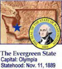
| Capital | Olympia |
| Nicknames | Evergreen State ...and more |
| Motto | Al-ki (By and by) |
| Location Region |
47.04191 N, 122.89376 W Pacific States Northwestern Northwest, Pacific |
| Constitution Ratified | 1889 |
| Statehood | November 11, 1899 42nd state |
| Population | 6,724,540 (2010) 88.52 sq. mi. 15th |
| Largest City (by population) |
10 largest cities (2010 est.):Seattle, 608,660; Spokane, 208,916; Tacoma, 198,397; Vancouver, 161,791; Bellevue, 122,363; Everett, 103,019; Kent, 92,411; Yakima, 91,067; Renton, 90,927; Spokane Valley, 89,755 |
| Bordering States | North: Canadian province of British Columbia East: Idaho South: Oregon (Columbia River forms much of the S boundary) West: Pacific Ocean North West: Juan de Fuca Strait, Haro Strait, and the Strait of Georgia separate the state from Canada's Vancouver Island) (Puget Sound deeply indents the Northwestern part of the state) All bodies of water contain numerous islands that form part of the state. Coastline: 157 mi. |
| Major Industry | farming (fruit, berries, nuts, cattle, wheat), lumber, tourism, hydroelectric power, computer software, aircraft, aluminum refining |
| Major Rivers | Columbia River, Snake River, Yakima River |
| Major Lakes | Lake Franklin D. Roosevelt, Lake Washington |
| Washington Counties | 39 Counties in Washington |
| Largest County (by population) |
King County 1,931,249 (2010) 2,126 sq. mi. |
| Largest County (by area) |
Okanogan County 5,268 sq. mi. |
| State forest lands | 2.1 million ac. |
| Electoral Votes | 11 |
| State parks | 120 |
| US Congress | 2 Senators; 9 Representatives |
| Time Zone | Pacific Standard Time |
| Zip Codes | NANPA |
| State Quick Facts | Census Bureau Quick Facts |
Washington Climate and Weather |
|
|---|---|
| Washington's climate varies greatly from west to east.
The west is mild and humid, while east of the Cascades a cooler dry climate prevails. The average annual temperature ranges from 51 degrees on the
Pacific coast to 40 degrees in the northeast. The climate in western Washington is mild because of the warm currents coming off of the North Pacific. This area has frequent cloud cover, considerable fog, and long-lasting drizzles. Summer is much sunnier, yet still mild. Average high temperatures here approach 70 degrees. The western side of the Olympic Peninsula receives up to 160 inches of precipitation annually, making it the wettest area of the 48 continental states. Weeks or even months may pass without a clear day. Portions of the Puget Sound area, on the eastern side of the Olympic Mountains, are less wet, although still humid. The western slopes of the Cascade Range receive some of the heaviest annual snowfall in the country (over 200 inches annually) |
|
| Highest Temperature | 118 degrees August 5, 1961 - Ice Harbor Dam |
| Lowest Temperature | -48 degrees December 30, 1968 - Mazama and Winthrop |
| Avg. Temp: High - Low |
84.0 degrees - 20.0 degrees |
Washington Points of Interest |
|
| Columbia River Gorge, Mt. Rainier, Mount St. Helens, Seattle, Puget Sound and the San Juan Islands, Olympic National Park and Spokane "Near Nature, Near Perfect". | |
Washington Highest, Lowest, and Mean Elevations (Feet) |
|
| Mean Elevation: 1,700 feet | |
|
Highest Point: Mt. Rainier: 14,410 feet
|
|
| Lowest Point: | Pacific Ocean Sea level |
Washington Land Area (Square Miles) |
|
| Geographic Center | In Chelan County, 10 mi. WSW of Wenatchee Longitude: 120°16.1'W Latitude: 47°20.0' N |
| Total Area | 71,299.64 sq. mi 18th |
| Land Area | 66,544.06 sq. mi 93.34% |
| Water Area | 4,755.58 sq. mi 6.66% |
| Forested Land Area | 51.4% |
| Dimensions (Length - Width) |
360 miles - 240 miles |
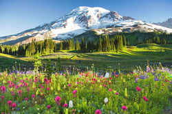 Mount Rainier is the highest and
third most voluminous volcano of the Cascade Range. The main cone of this stratovolcano has formed since 730,000 years ago. Mount Rainier is potentially
the most dangerous volcano in the Cascades because it is very steep, covered in large amounts of ice and snow, and near a large population that lives
in lowland drainages. Numerous debris avalanches start on the volcano. The largest debris avalanche traveled more than 60 miles (100 km) to Puget
Sound. The most recent eruption was about 2,200 years ago and covered the eastern half of the park with up to one foot (30 cm) of lapilli, blocks,
and bombs
Mount Rainier is the highest and
third most voluminous volcano of the Cascade Range. The main cone of this stratovolcano has formed since 730,000 years ago. Mount Rainier is potentially
the most dangerous volcano in the Cascades because it is very steep, covered in large amounts of ice and snow, and near a large population that lives
in lowland drainages. Numerous debris avalanches start on the volcano. The largest debris avalanche traveled more than 60 miles (100 km) to Puget
Sound. The most recent eruption was about 2,200 years ago and covered the eastern half of the park with up to one foot (30 cm) of lapilli, blocks,
and bombsAdams, Asotin, Benton, Chelan, Clallam, Clark, Columbia, Cowlitz, Douglas, Ferry, Franklin, Garfield, Grant, Grays Harbor, Island, Jefferson, King, Kitsap, Kittitas, Klickitat, Lewis, Lincoln, Mason, Okanogan, Pacific, Pend Oreille, Pierce, San Juan, Skagit, Skamania, Snohomish, Spokane, Stevens, Thurston, Wahkiakum, Walla Walla, Whatcom, Whitman, Yakima

