


Click Image to Enlarge
Washington Counties
There are thity-nine counties in the state of Washington. Washington was carved out of the western part of Washington Territory and admitted to the Union as the 42nd state in 1889. The first counties were created from unorganized territory in 1845.Franklin County, Washington
Franklin County Education, Geography, and History
Franklin County is a county located in the state of Washington. Based on the 2010 census, its population was 78,163. The county seat and
largest city is Pasco. The county was formed out of Whitman County on November 28, 1883[ and is named for Benjamin Franklin.
Franklin County is included in the Kennewick-Richland, WA Metropolitan Statistical Area.
Etymology - Origin of Franklin County Name
Benjamin Franklin, the famous Founding Father, statesman, printer, and scientist.
Demographics:
County QuickFacts: CensusBureau Quick Facts
Franklin County History
Franklin County was created 28 November 1883 from Whitman County.
Franklin County is situated in south-central Washington state. The Columbia River forms its western border and the Snake River forms the southern and eastern borders. The natural shrub-steppe landscape is composed predominately of bunchgrass and sagebrush. There is little rainfall, but the soil is fertile and can grow anything with adequate moisture. Native Americans long hunted game and fished for salmon in the area. White prospectors traveled through in the 1850s on their way to the gold rush in British Columbia and some stayed to raise sheep and plant orchards. Then the railroads came, securing the county's future. The county was created in 1887, and named for Ben Franklin (1706-1790), the American statesman. Franklin County's first permanent settlements were railroad stations.
Franklin County
Railroad expansion in the Pacific Northwest created Ainsworth, located at the confluence of the Snake and Columbia Rivers, and the first town in Franklin County. Settled in 1879 as a depot for construction supplies and equipment, the town was named after
J.C. Ainsworth, President of the Oregon Steam Navigation Company. Ainsworth's company had a monopoly on all shipping on the Columbia River they held for 20 years. Ainsworth 1884
During its heyday, Ainsworth was a rough-and-tough town which fluctuated in population from 300 to 1500 persons and included a great many Chinese laborers among the railroad construction workers. Ainsworth soon garnered a reputation as a "wild-and-wicked spot of sin" because of the people railroad
construction attracted. A noted surveyor, Lt. Thomas W. Symons, described Ainsworth as "one of the most uncomfortable, abominable places in America to live in." Saloons, gambling emporiums, opium dens and houses of ill-repute were all prominent businesses accompanied by their share of crime,
violence and lawlessness.
Yet in spite of Ainsworth's reputation, a respectable and responsible populace called the humble town "home." Residences had few conveniences and were furnished with nothing more than simple homemade furniture. Though windmills and wells were rare, Ainsworth was home to butcher shops, dairy,
barbers, millinery, general merchandise stores, shoemakers, a dressmaking store, a notion & variety store and a Chinese laundry. Due to its location and railroad and river service Ainsworth was one of the busiest places in the Territory, serving as a transfer point for a variety of goods such as
wheat, cattle, sheep, and railroad materials.
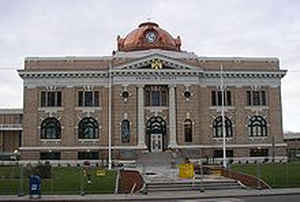
In 1883 Franklin County was created and Ainsworth became the county seat. However, when the Northern Pacific began to build a new line in the Yakima Valley, Ainsworth's population dwindled because the towns of Kennewick and Pasco were founded and the influx of people to the city of North Yakima. A
few years later, the railroad moved all of its property to the site of the new county seat, Pasco, and the courthouse was later moved in 1887. Courthouse
It had been Pasco's fate to prosper from Ainsworth's demise. Pasco was established as a Northern Pacific station in 1884 but it was named in 1881 by Virgil C. Brogue, the principal engineer of the Northern Pacific Cascade construction branch, probably in jest after his most recent job at Cerro de
Pasco in the brisk cool mountain air of the Andes in Peru.
Early homesteaders in the area were W.H. Steffins, Dewitt Owen, Frank Shunemann, Henry Gantenbein, Jr., Rudolph Gantenbein, D.D. Sylvester and W.B. Mitzel. Captain W.P. Gray and Denver speculator Louis C. Frey later formed the Pasco Land Company to attract further settlers who eventually populated
the small but dynamic community of Pasco. Platted in 1886, Pasco was incorporated in 1891.
During its early years, Pasco's most ambitious "claim to fame" was its challenge to Olympia (along with Centralia, Yakima, Ellensburg, and assorted other towns) to become the state capital in 1889. Despite being soundly ridiculed by those oblivious to its inherent charms, Pasco found itself awash in
civic pride. Captain W.P. Gray was Pasco's main booster, not just for the anticipated increase in value of his substantial property claims should Pasco in fact become the capital. Capt. Gray
With the editorial assistance of I.I. Muncie, publisher of the , Pasco's praises were sung. Rallying under the banner of "Keep Your Eye on Pasco" and promoting its ideal climate and superior location (three mighty rivers and a virtual octopus of railroad tracks), Pasco all but guaranteed its
continued prosperity and was therefore the prime site for the state capital.
Consequently, Pasco citizens enthusiastically pledged $40,000 and 300 acres. But it was not to be. Rebounding in the political safety net of incumbency, Olympia, though forced into a run-off election with Yakima and Ellensburg, received enough votes to become the capital for the new state of
Washington.
Of the 50,000 plus votes cast, Pasco received 130, a more-than-respectable turnout when one considers the population of less than 500 inhabitants. Putting a positive spin on the rather lack-luster outcome, Pasco emphasized the state-wide publicity it had received, and then quietly rode back into the
sunset, perhaps unaware that it would have higher aspirations to fulfill in future times.
Kahlotus- Though not platted until 1902, Kahlotus was located seven miles north of the Snake River and attracted early settlers such as the Harders and Moritz brothers, the Ebeson brothers, the Timmermanns, Parkinsons, and Hutchinson's in the early 1880s. In 1883 the Northern Pacific Railroad (who
recruited many homesteaders to the area) arrived in the area. With the influx of new people, by 1886 the first Post Office was established, and in 1887 the first school in Franklin County was built.
By 1906 when the Spokane, Portland, and Seattle Railroad was built, Kahlotus was the largest wheat shipping point in Franklin County and a thriving town with a hotel, bank, livery stable, saloon, newspaper, hardware furniture store, and grocery and general merchandise store. Unfortunately by 1900
the railroad bypassed Kahlotus and today this once thriving town remains a small but productive farming community, home to approximately 500 people. Tacoma Ave., Pasco 1900
White Bluffs-The small settlement of White Bluffs on the eastern side of the Columbia River is considered by many to be the first town in Franklin County. Long a crossroads for migratory Indian tribes, it was the site of a temporary military depot established by the army in the 1850s. White Bluffs
also attracted gold miners on their way to fame and fortune up north and served as a shipping center for freight coming up the Columbia until 1868 and. In 1865 the Hudson's Bay Company commissioned A. R. Booth as the agent of a way station and trading hut at White Bluffs, joining many houses, a
store, a blacksmith shop and a saloon. A ferry, which ran until 1943, was originally operated by Thomas Howe.
The 1870s brought their share of Indian problems to the White Bluffs' area, causing another temporary stationing of military personnel. By the 1890s many of the homesteaders had moved to the west side of the river and in 1907 the town of White Bluffs was re-established on the western side of the
Columbia River (and in Benton County). In 1943 under a veil of secrecy, White Bluffs was quietly confiscated and quickly razed by the US government and incorporated into the Hanford Reservation's Manhattan Project.
This information was provided courtesy of Mary Warring, former President of the Ferry County Historical Society.
Economic
The Tri-Cities MSA is the fourth largest Metropolitan Statistical Area (MSA) in the state of Washington. The Tri-Cities is located in southeast Washington and is situated at the confluence of the Columbia, Yakima and Snake Rivers. With a population of 228,023, the major communities are Kennewick, Pasco, and Richland.
A modern interstate highway system brings the major metropolitan areas of Seattle and Portland within three hours driving time. Spokane lies two hours to the north and Idaho is east approximately the same distance. These major highways provide dependable year-round transportation routes for the agricultural and manufactured commodities leaving the Tri-Cities for world markets.
Geography: Land and Water
As reported by the Census Bureau, the county has a total area of 1,265 square miles (3,277 km2), of which,
1,242 square miles (3,218 km2) of it is land and 23 square miles (59 km2) of it (1.81%) is water.
Neighboring Counties
Bordering counties are as follows:
- Adams County, Washington - north
- Whitman County, Washington - east
- Walla Walla County, Washington - southeast
- Benton County, Washington - southwest
- Grant County, Washington - northwest
Education


Click Image to Enlarge
