


Click Image to Enlarge
Washington Counties
There are thity-nine counties in the state of Washington. Washington was carved out of the western part of Washington Territory and admitted to the Union as the 42nd state in 1889. The first counties were created from unorganized territory in 1845.Grays Harbor County, Washington
Grays Harbor County Education, Geography, and History
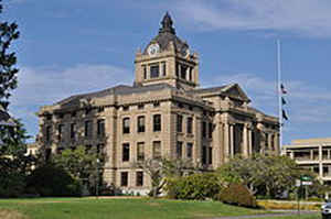
Grays Harbor County is a county in the state of Washington. Based on the 2010 census, the population was 72,797. The county seat is
Montesano, and its largest city is Aberdeen. The county is named after a large estuarine bay near its southwestern corner. On May 7, 1792,
Boston fur trader Robert Gray crossed the bar into the bay he called Bullfinch Harbor, but which later cartographers would label Chehalis Bay,
and then Grays Harbor.
Grays Harbor County comprises the Aberdeen, WA Micropolitan Statistical Area.
Etymology - Origin of Grays Harbor County Name
Grays Harbor County takes its name from the broad, shallow bay that drains five rivers in southwest Washington.
Demographics:
County QuickFacts: CensusBureau Quick Facts
Grays Harbor County History
The county, originally named Chehalis County, was formed out of Thurston County on April 14, 1854. Its name was subsequently changed to Grays Harbor County by the Washington legislature, effective June 9, 1915. The name change helped eliminate confusion resulting from the fact that the city named Chehalis was in Lewis County.
Economic
Grays Harbor County is located on the Coast of Washington State. It is bounded to the north by Jefferson County,
to the south by Pacific and Lewis Counties, and to the east by Mason and Thurston Counties.
The confluence of Grays Harbor and the Chehalis River is 50 miles west of Olympia, 110 miles southwest of Seattle,
and 140 miles northwest of Portland, Oregon. The area's topography is naturally varied from rolling tree-covered
hills to sandy ocean beaches. Interior river valleys give way to rugged mountains in the northern part of the
county. Grays Harbor County is 1,917 square miles (1,227,072 acres) in area ranking it 15th largest of Washington's
39 counties. The county averages 35 residents per square mile.
Geography: Land and Water
As reported by the Census Bureau, the county has a total area of 2,224 square miles (5,761 km2), of which, 1,917 square miles (4,965 km2) of it is land and 308 square miles (797 km2) of it (13.83%) is water.
The
dense forests of spruce, hemlock, cedar, and Douglas fir attracted loggers and mill operators and at the turn of the
twentieth century, communities such as Aberdeen, Hoquiam, Cosmopolis, and Montesano flourished. Immigrant wage earners
flooded in to harvest green gold. One hundred years later, the county struggled to reinvent itself without logging,
milling, and fishing. The Native Americans who were shoved aside by the settlers reemerged with self-government and new
enterprises.
Neighboring Counties
Bordering counties are as follows:
- Jefferson County, Washington - north
- Mason County, Washington - northeast
- Thurston County, Washington - east/southeast
- Lewis County, Washington - south/southeast
- Pacific County, Washington - south
Education


Click Image to Enlarge
