


Click Image to Enlarge
Washington Counties
There are thity-nine counties in the state of Washington. Washington was carved out of the western part of Washington Territory and admitted to the Union as the 42nd state in 1889. The first counties were created from unorganized territory in 1845.Jefferson County, Washington
Jefferson County Education, Geography, and History
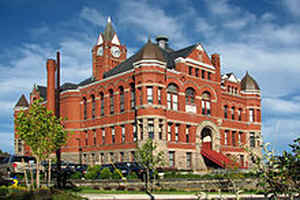
Jefferson County is a county located in the state of Washington. Based on the 2010 census, the population was 29,872. The county seat and
only incorporated city is Port Townsend. The county is named for Thomas Jefferson.
Jefferson County was formed out of Thurston County on December 22, 1852, by the legislature of Oregon Territory, and included the northern
4,854 square miles (12,571.8 km2) portion of the Olympic Peninsula. On April 26, 1854, the legislature of Washington Territory created Clallam
County from the northwestern 2,670 square miles (6,915.3 km2) portion of this original area.
Etymology - Origin of Jefferson County Name
Thomas Jefferson, the third president of the United States.
Demographics:
County QuickFacts: CensusBureau Quick Facts
Jefferson County History
Jefferson County, located on the Olympic Peninsula in northwestern Washington, was created by the Oregon Territorial Legislature on December 22, 1852, from a portion of Lewis County. It was named in honor of President Thomas Jefferson who, by commissioning the Lewis and Clark Expedition (1804-1806), was instrumental in the exploration of the Pacific Northwest. Jefferson County has an area of 2,184 square miles, 1,814 square miles of land and 369 square miles of water. Approximately 60 percent of the county comprises the Olympic National Park and Olympic National Forest; another 20 percent is under the jurisdiction of other federal and state agencies. The Washington Territorial legislature determined the boundary lines in 1877. The county is bounded on the north by Clallam County and the Strait of Juan de Fuca, on the south by Grays Harbor and Mason Counties; on the east by Hood Canal and Admiralty Inlet; and the on the west by the Pacific Ocean. The county seat is Port Townsend.
Geography: Land and Water
As reported by the Census Bureau, the county has a total area of 2,184 square miles (5,655 km2), of which,
1,814 square miles (4,699 km2) of it is land and 369 square miles (956 km2) of it (16.91%) is water.
The county is split in three parts by its landforms:
- Eastern Jefferson County along the Strait of Juan de Fuca, Admiralty Inlet, and Puget Sound
- Central Jefferson County, which is uninhabited and lies in the Olympic Mountains within Olympic National Park and Olympic National Forest
- Western Jefferson County, along the Pacific Ocean.
Because of the mountainous barrier, there is no road lying entirely within Jefferson County that connects the eastern and western parts. The most direct land route between the two ends of the county involves a drive of approximately 100 miles along US Route 101 through neighbouring Clallam County. The mountains also block the damp Chinook winds, which make the climate very much more wet in the West than the so-called Eastern "banana belt" in the rain shadow. The original formation of Jefferson County during a time when the Oregon Territory was poorly explored is now generally recognized as a geographical error, but an error which cannot be conveniently rectified.
Neighboring Counties
Bordering counties are as follows:
- Island County, Washington - northeast
- Kitsap County, Washington - southeast
- Mason County, Washington - south/southeast
- Grays Harbor County, Washington - south/southwest
- Clallam County, Washington - northwest
- San Juan County, Washington - northeast (water boundary only, in Strait of Juan de Fuca).
Education


Click Image to Enlarge
