


Click Image to Enlarge
West Virginia Counties
There are fifty-five counties in the state of West Virginia. Fifty of them existed at the time of the Wheeling Convention in 1861, before which West Virginia was part of the state of Virginia. The remaining five (Grant, Mineral, Lincoln, Summers and Mingo) were formed within the state after its admission to the United States on June 20, 1863. At that time, Berkeley County and Jefferson County, the two easternmost counties of West Virginia, refused to recognize their inclusion in the state. In March 1866, the US Congress passed a joint mandate assenting to their inclusion.Boone County, West Virginia
Boone County Education, Geography, and History
Boone County is a county located in the state of West Virginia. Based on the 2010 census, the population was 24,629. Its county seat is Madison.
The county was formed in 1847 from parts of Kanawha, Cabell, and Logan Counties and named for Daniel Boone, noted hunter and explorer, whose home
was in the Great Kanawha Valley from 1789 to 1795.
Boone County is part of the Charleston, WV Metropolitan Statistical Area
Etymology - Origin of Boone County Name
The county was named for Daniel Boone (1734-1820), the famous hunter and explorer, founder of Kentucky, Lieutenant Colonel of the Virginia militia, and member of the Virginia General Assembly representing Kanawha County (in 1791).
Demographics:
County QuickFacts: CensusBureau Quick Facts
Early History of Boone County, West Virginia
Boone County was created by an act of the Virginia General Assembly on March 11, 1847 from parts of Cabell, Kanawha, and Logan counties. The county was named for Daniel Boone (1734-1820), the famous hunter and explorer, founder of Kentucky, Lieutenant Colonel of the Virginia militia, and member of the Virginia General Assembly representing Kanawha County (in 1791).
Although known as a son of Kentucky, Daniel Boone was born on November 2, 1734 in the Schuylkill Valley in Pennsylvania. He moved with his parents to Yadkin Valley, North Carolina in 1750. He later married and started a family there and was active as an Indian trader in that area. He visited the present site of West Virginia in 1755 as a member of General Braddock's army that was defeated by the Indians on the Monongahela River. A few years later he explored the future site of Kentucky and moved his family there. In 1788, he lost his Kentucky property because he failed to properly enter his land grants. Homeless, he moved to Point Pleasant, in West Virginia, for nearly a year, and then moved to present day Charleston. He lived there for seven years (1788-1795). He was named a Lieutenant Colonel of the state militia in 1789, and, in 1790, he was elected to the Virginia General Assembly. He left West Virginia in 1799, moving to Missouri, where he had been granted 1,000 acres of land by the Spanish government and given a government position overseeing the area. He died on September 26, 1820 in Missouri.
John Peter Salley was the first Englishman to explore what is now called Boone County. He passed through the area in 1742. He is credited for the discovery of coal in the state, along the Coal River. Richard Hewett was exploring in the county when he was killed by Indians at the mouth of Hewett Creek in 1782. The county, and all of the present state of West Virginia, was the hunting grounds for several Indian tribes, including the Cherokee, Miami, and Delaware Indians, and the Europeans were considered trespassers.
By the end of the American Revolutionary War in 1783, there were very few Indians left in the county. Now that the county was considered relatively safe, English trappers and explorers, whose names were never recorded, began to enter the county in search of beaver pelts and adventure. The first, permanent English settlers arrived during the early 1790s.
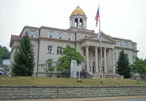
The first meeting of the county court was held on the land of Albert Allen, at the mouth of Spruce Fork, across from present day Madison in 1847. The original courthouse was burned by the Union Army during the Civil War. The county court was then held at the Ballardsville Methodist Episcopal Church until 1866 when it was relocated to the lands of Johnson Copley, in Madison.
Madison, the county seat, was incorporated in 1906. Some historians claim that the town was named in honor of William Madison Peyton, a leader of the movement to form Boone County and a pioneer coal operator. Others have suggested that it was named in honor of James Madison (1751-1836) the 4th President of the United States (1809-1817), a leading member of the Philadelphia Convention that wrote the US Constitution, and life-long friend and neighbor of Thomas Jefferson, the 3rd President of the United States (1800-1809).
Geography: Land and Water
As reported by the Census Bureau, the county has a total area of 503 square miles (1,300 km2), of which 502 square miles (1,300 km2) is land and 1.7 square miles (4.4 km2) (0.3%) is water
Neighboring Counties
Bordering counties are as follows:
- Northeast: Kanawha County
- Northwest: Lincoln County
- Southeast: Raleigh County; Wyoming County
- Southwest: Logan County
Education


Click Image to Enlarge
