


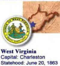
West Virginia State Almanac: Facts and Figures
Quick Facts, Figures, and Overview of the State of West Virginia
West Virginia is one of the South Atlantic states of the US. It lies in the Appalachian region and its neighbors are the US states of Kentucky, Ohio, Virginia, Pennsylvania, and Maryland. Until 1861 West Virginia was part of Virginia. West Virginia was named to honor Queen Elizabeth of England often referred to as the "Virgin Queen."
The state's rapid industrial expansion began in the 1870s, drawing thousands of European immigrants and African Americans into the region. Miners' strikes between 1912 and 1921 required the intervention of state and federal troops to quell the violence.
Today, the state ranks second in total coal production, with about 12.5% of the U.S. total. It is also a leader in steel, glass, aluminum, and chemical manufactures. Major agricultural commodities are broilers, cattle and calves, chicken eggs, dairy products, and turkeys
West Virginia Almanac: Facts on West Virginia |
|
|---|---|
| Official Name | West Virginia |
| Capital | Charleston |
| Nicknames | Mountain State ...and more |
| Motto | Montani Semper Liberi (Mountaineers always free) |
| Location Region |
38.35055 N, 081.63043 W Appalachia Southern |
| Constitution Ratified | 1872 |
| Statehood | June 20, 1863 35th state |
| Population | 1,852,994 (2010) 78.08 sq. mi. 37th |
| Largest City (by population) |
10 largest cities (2010 est.): Charleston, 51,400; Huntington, 49,138; Parkersburg, 31,492; Wheeling, 28,486; Morgantown, 29,660; Weirton, 19,746; Fairmont, 18,704; Beckley, 17,614; Clarksburg, 16,578; Martinsburg, 17,227 |
| Bordering States | North: Ohio and Pennsylvania North East: Maryland (Potomac River forms part of the Northeastern boundary) East and South: Virginia (Tug Fork and Big Sandy rivers form almost all of the Southwestern boundary) West: Kentucky and Ohio (Ohio River forms the West and Northwestern boundaries) |
| Major Industry | mining (coal), livestock, chemical manufacturing, glass products, tourism |
| Major Rivers | Ohio River, Guyandotte River, Greenbrier River |
| Major Lakes | Tygart Lake, Bluestone Lake |
| West Virginia Counties | 55 Counties in West Virginia |
| Largest County (by population) |
Kanawha County 193,063 (2010) 903 sq. mi. |
| Largest County (by area) |
Randolph County 1,040 sq. mi. |
| State forests | 9 (79,502 ac.) |
| State parks | 37 (74,508 ac.) |
| Electoral Votes | 5 |
| US Congress | 2 Senators; 3 Representatives |
| Time Zone | Eastern Standard Time |
| Zip Codes | NANPA |
| State Quick Facts | Census Bureau Quick Facts |
West Virginia Climate and Weather |
|
|---|---|
| West Virginia has four distinct seasons.
Its mountainous terrain means that there can be marked differences in the weather at any one time - the mountains tend to be cooler than the rest
of the state (and downright cold in winter). Summer is hot and rainy in most of the state, with highs in the upper 80s F/30 C (80 F/26 C in the mountains).
Opportunities for hiking, camping and white-water rafting begin in the spring and last until autumn. Spring temperatures range 43-76 F/5-24 C, with lots of runoff from the 60+ in/152+ cm of snow in the mountains. Summer thundershowers help keep river levels up. The ski season usually runs November-February. Winter temperatures range 19 to 40 F/-7 to -4 C in the mountains, with occasional drops to 0 F/-18 C. Most attractions are open year-round. Except for those travelers interested in winter sports, we recommend visiting West Virginia in the spring for white-water rafting and in summer and fall for touring. |
|
| Highest Temperature | 112 degrees July 10, 1936 -Martinsburg |
| Lowest Temperature | -37 degrees December 17, 1917 - Lewisburg |
| Avg. Temp: High - Low |
85.6 degrees - 23.9 degrees |
West Virginia Points of Interest |
|
|
West Virginia offers
experiences that bring history and nature to life. Some of the state's most popular attractions include Blackwater Falls, Monongahela National Forest, Northeast Panhandle, Organ Cave, White Sulphur Springs, worldclass whitewater-rafting venues and the ski resorts in the Allegheny Mountains. |
|
West Virginia Highest, Lowest, and Mean Elevations (Feet) |
|
| Mean Elevation: 1,500 feet | |
|
Highest Point: Spruce Knob: 4,861 feet
|
|
| Lowest Point: | Potomac River 240 feet |
West Virginia Land Area (Square Miles) |
|
| Geographic Center | In Braxton County, 4 mi. E of Sutton Longitude: 80°42.2'W Latitude: 38°35.9'N |
| Total Area | 24,229.76 sq. mi. 41st |
| Land Area | 24,077.73 sq. mi. 99.38% |
| Water Area | 152.03 sq. mi. 0.62% |
| Forested Land Area | 78.5% |
| Dimensions (Length - Width) |
240 miles - 130 miles |
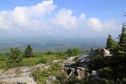 At 4,861 feet above sea level, Spruce
Knob is West Virginia's highest peak. From this rugged alpine peak, you can view grassy openings and pastures or look down on forested ridges as
far as the eye can see.
At 4,861 feet above sea level, Spruce
Knob is West Virginia's highest peak. From this rugged alpine peak, you can view grassy openings and pastures or look down on forested ridges as
far as the eye can see.Barbour, Berkeley, Boone, Braxton, Brooke, Cabell, Calhoun, Clay, Doddridge, Fayette, Gilmer, Grant, Greenbrier, Hampshire, Hancock, Hardy, Harrison, Jackson, Jefferson, Kanawha, Lewis, Lincoln, Logan, Marion, Marshall, Mason, McDowell, Mercer, Mineral, Mingo, Monongalia, Monroe, Morgan, Nicholas, Ohio, Pendleton, Pleasants, Pocahontas, Preston, Putnam, Raleigh, Randolph, Ritchie, Roane, Summers, Taylor, Tucker, Tyler, Upshur, Wayne, Webster, Wetzel, Wirt, Wood, Wyoming

