


Click Image to Enlarge
West Virginia Counties
There are fifty-five counties in the state of West Virginia. Fifty of them existed at the time of the Wheeling Convention in 1861, before which West Virginia was part of the state of Virginia. The remaining five (Grant, Mineral, Lincoln, Summers and Mingo) were formed within the state after its admission to the United States on June 20, 1863. At that time, Berkeley County and Jefferson County, the two easternmost counties of West Virginia, refused to recognize their inclusion in the state. In March 1866, the US Congress passed a joint mandate assenting to their inclusion.Hancock County, West Virginia
Hancock County Education, Geography, and History
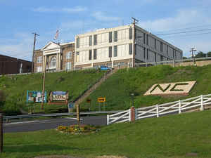
Hancock County is a county located in the state of West Virginia. Based on the 2010 census, the population was 30,676. Its county seat is
New Cumberland. The county was created from Brooke County in 1848 and named for John Hancock, first signer of the Declaration of Independence.
Hancock County is the farthest north in the state, being at the tip of the state's Northern Panhandle.
Hancock County is part of the Weirton-Steubenville, WV-OH Metropolitan Statistical Area, which is also included in the Pittsburgh-New
Castle-Weirton, PA-OH-WV Combined Statistical Area
Etymology - Origin of Hancock County Name
For John Hancock, first signer of the Declaration of Independence
Demographics:
County QuickFacts: CensusBureau Quick Facts
Early History of Hancock County, West Virginia
Hancock County was created by an act of the General Assembly on January 15, 1848 from parts of Brooke County. It is the smallest county in the state (88.55 square miles). It was named in honor of John Hancock (1737-1793). He was born on January 12, 1737 in Quincy, Massachusetts, was a leader in the American Revolution, served as President of the Provincial Congress of Massachusetts from 1774 to 1775, President of the Continental Congress from 1775 to 1777, Governor of the state of Massachusetts from 1780 to 1785 and 1787 to 1793, and the first signer of the Declaration of Independence. He died on October 8, 1793.
Robert Cavelier de La Salle was probably the first European to set foot in present Hancock County. He sailed down the Ohio River in 1669. In 1749, Louis Bienville de Celeron sailed down the Ohio River and may have set foot on present day Hancock County. He claimed all of the lands drained by the Ohio River for King Louis XV of France. He met several English fur traders on his journey and ordered them off of French soil and wrote strong letters of reprimand to the colonial governors protesting the English's presence on French soil.
The first known settler in the county was a man named Holliday who settled in what is still known as Holliday's Cove in 1776. Following the Revolutionary War, Colonel Richard Brown and his family settled on a tract of 1,000 acres in Holliday's Cove. By the early 1790s, several other families had moved into the area.
The act creating the county left the location of the county seat to the electorate, which selected New Cumberland over New Manchester by a narrow margin of 13 votes. The county court had been meeting in New Manchester and the judges initially refused to move the court to New Cumberland. A second election was held in 1850, with New Cumberland winning once again, this time by 46 votes. The county court was then moved to New Cumberland, but a third election in 1852 resulted in New Manchester receiving one more vote than New Cumberland. The county seat then returned to New Manchester until later returning to New Cumberland.
New Cumberland was originally called Brick Bend because of the many brickyards and pottery works that were located there. The city was begun in 1784 and named Cuppytown for its founder, John Cuppy. In 1839, John Cuppy formally laid out the town into 42 lots and called it Vernon, but later changed the name to New Cumberland in deference to the wishes of the first purchasers of the lots. The town was incorporated by the West Virginia state legislature in 1872.
In 1794, Peter Tarr built an iron processing furnace on King's Creek, near New Cumberland. The "Old Tarr Furnace" was the first of its kind west of the Allegheny Mountains and has the distinction of having been the place where the cannonballs that Commodore Perry fired from the guns of his ships in the Battle of Lake Erie in 1813 were made.
Geography: Land and Water
As reported by the Census Bureau, the county has a total area of 88 square miles (230 km2), of which 83 square miles (210 km2)
is land and 5.4 square miles (14 km2) (6.1%) is water.[
It is the smallest county in West Virginia by area. The highest point of elevation in Hancock County is approximately 1363 ft. and located
about 1800 ft. ESE of Emmanuel Mission Church
Neighboring Counties
Bordering counties are as follows:
- Northeast: Beaver County, Pa.
- Northwest: Columbiana County, Ohio
- South: Brooke County
- Southeast: Washington County, Pa.
- Southwest: Jefferson County, Ohio
Education


Click Image to Enlarge
