


Click Image to Enlarge
West Virginia Counties
There are fifty-five counties in the state of West Virginia. Fifty of them existed at the time of the Wheeling Convention in 1861, before which West Virginia was part of the state of Virginia. The remaining five (Grant, Mineral, Lincoln, Summers and Mingo) were formed within the state after its admission to the United States on June 20, 1863. At that time, Berkeley County and Jefferson County, the two easternmost counties of West Virginia, refused to recognize their inclusion in the state. In March 1866, the US Congress passed a joint mandate assenting to their inclusion.Putnam County, West Virginia
Putnam County Education, Geography, and History
Putnam County is a county located in the state of West Virginia. Based on the 2010 census, the population was 55,486. Its county seat is
Winfield. The county was founded in 1848 and is named for Israel Putnam, who was a hero in the French and Indian War and a general in the
American Revolutionary War.
Putnam County is part of the Huntington-Ashland, WV-KY-OH Metropolitan Statistical Area, which is also included in the
Charleston-Huntington-Ashland, WV-OH-KY Combined Statistical Area.
Etymology - Origin of Putnam County Name
In honor of General Israel Putnam, New England soldier and patriot
Demographics:
County QuickFacts: CensusBureau Quick Facts
Early History of Putnam County, West Virginia
Putnam County was created by an act of the Virginia General Assembly on March 11, 1848, from parts of Cabell, Kanawha and Mason counties. It was named in honor of General Israel Putnam of Massachusetts (1718-1790).
General Putnam was born in Salem, Massachusetts on January 7, 1718. He later moved to Connecticut where he owned and operated a farm. In 1755, he was appointed the commander of the Connecticut militia during the French and Indian War. He served with distinction and retired after the war to his farm in Connecticut. He was reactivated as the commander of the Connecticut militia during the American Revolutionary War. He commanded the American Army at the Battle of Bunker Hill and, for his services during the war, was promoted to the rank of major General, one of the first four major generals in the American Revolutionary Army. He retired from the military in 1779, due to ill health. He died on May 29, 1790.
George Washington, who surveyed the county's Buffalo district in the fall of 1770, was probably the first man of European descent to set foot in the county. James Conner was the first settler. He arrived in 1775. In 1785, Theopolus Armour, his wife, son and baby attempted a settlement in the county, but his wife and baby were killed by Indians and he returned back east with his son. In 1799, Charles Connor, James Ellis and John Dudding moved to the county. Ellis built a cabin on the shore of Big Hurricane and John Dudding built a cabin on the Kanawha River.
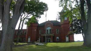
Winfield, the county seat, was established on a 400 acre tract of land owned by Charles Brown. He established a ferry across the river in 1818. The first meeting of the county court was held at the home of Talleyrand P. Brown, in Winfield, on May 22, 1848. The town was incorporated on February 21, 1868 and named in honor of General Winfield Scott, the commanding General of the American Army during the War with Mexico.
The first Civil War engagement of significance in the Kanawha Valley was fought at Scary Creek, across the river from present day Nitro, on July 17, 1861. The Union Army, consisting primarily of troops from Ohio, suffered 23 fatalities during the battle while the Confederate Army, under the command of former Virginia Governor Henry A. Wise, had relative few losses. Despite the apparent victory, the Confederate Army decided to fall back to Charleston, and soon after left the valley to take up the fight in other parts of the state.
Geography: Land and Water
As reported by the Census Bureau, the county has a total area of 350 square miles (910 km2), of which 346 square miles (900 km2) is land and 4.7 square miles (12 km2) (1.3%) is water
Neighboring Counties
Bordering counties are as follows:
- Northeast: Jackson County
- Northwest: Mason County
- Southeast: Kanawha County
- Southwest: Lincoln County; Cabell County
Education


Click Image to Enlarge
