


Click Image to Enlarge
West Virginia Counties
There are fifty-five counties in the state of West Virginia. Fifty of them existed at the time of the Wheeling Convention in 1861, before which West Virginia was part of the state of Virginia. The remaining five (Grant, Mineral, Lincoln, Summers and Mingo) were formed within the state after its admission to the United States on June 20, 1863. At that time, Berkeley County and Jefferson County, the two easternmost counties of West Virginia, refused to recognize their inclusion in the state. In March 1866, the US Congress passed a joint mandate assenting to their inclusion.Randolph County, West Virginia
Randolph County Education, Geography, and History
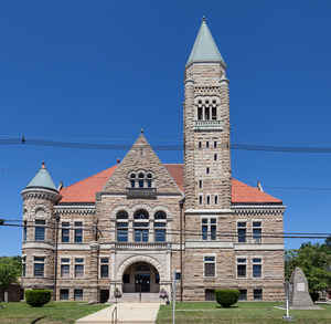
Randolph County is a county located in the state of West Virginia. Based on the 2010 census, the population was 29,405. Its county seat is
Elkins. The county was founded in 1787 and is named for Edmund Jennings Randolph.
Randolph County comprises the Elkins, West Virginia, Micropolitan Statistical Area.
Etymology - Origin of Randolph County Name
For Edmund Jennings Randolph, Governor of VA, 1786-1788
Demographics:
County QuickFacts: CensusBureau Quick Facts
Early History of Randolph County, West Virginia
Randolph County, the largest county in the state, was created by an act of the Virginia General Assembly in October 1786 from Harrison County. According to the first national census taken In 1790, Randolph County had the smallest population (951) of the nine counties that were then in existence and fell within the current boundaries of West Virginia. Berkeley County had the largest population (19,713) at that time. There was a total of 55,873 people living within the present state's boundaries at that time.
The county was named in honor of Edmund Jennings Randolph (1753-1813). He was born on August 10, 1753 in Williamsburg, Virginia to John "The Loyalist" Randolph (1727-1784) and Ariana Jennings. A graduate of William and Mary College, he studied the law and, in 1776, was appointed Attorney-General of the Commonwealth of Virginia. When the Revolutionary War broke out, he enlisted in the Continental Army and eventually became an aide-de-camp to General "The Loyalist"George Washington. After the war, he was a delegate to Continental Congress (1779-1789), a member of the Philadelphia Convention that wrote the US Constitution (he proposed the famous Virginia Plan that was only partially adopted by the delegates and he later refused to sign the document), and served as the Governor of Virginia from 1786 to 1789. In 1789, he was appointed the Attorney-General of the United States and remained in that position until 1794 when he was appointed the US Secretary of State. He left that office in 1795 and retired to his home in Virginia where he was active as a national leader in the Masons' organization. He died on September 13, 1813.
David Tygart and Robert Files (or Foyle) were the first settlers in the county (and the present state of West Virginia). They arrived in 1753 (or 1754). Files cabin was built near the present site of Beverly and Tygart's cabin was two miles north. The Tygart River and Valley are named in honor of David Tygart and Files Creek is named for Robert Files. That winter, Indians attacked the Files' cabin and killed him, his wife and five of his six children. One of his sons was not in the cabin at the time of the attack and escaped. He fled to Tygart's cabin to warn him of the Indians' presence and intentions. They all immediately left the county for good. Eighteen years passed before the next settlers arrived.
During Lord Dunmore's War in 1774, two small forts were built in the county, Westfall at Beverly and Currence near Huttonsville. The settlers in the area would gather there whenever Indians were about. It was not until 1777 that another settler was killed by the Indians. The Indians considered the settlers trespassers on their hunting grounds. Isolated incidents between the settlers living in the county and the Indians continued until 1781. In April of that year an Indian raiding party killed dozens of settlers in the county. Joseph Kinnan and three of his five children have the unfortunate honor of being the last settlers killed by Indians in the county. They were killed on May 11, 1791 and his wife was taken captive. She was released three years later after the Indians were defeated at the Battle of Fallen Timbers.
Beverly, originally known as Edmundton in honor of Edmund Randolph, was renamed Beverly by the Virginia General Assembly on December 16, 1790, in honor of Governor Beverly Randolph. It was then named the county seat. It was laid out on the lands of James Westfall. Elkins, named for US Senator Stephen Benton Elkins, a railroad magnate, lumber king, and wealthy banker, became the county seat after a three year battle with Beverly in 1900. At one point, a special train was formed at Elkins to mount an attack on Beverly. The attack was averted at the last moment, and the county seat subsequently was moved.
Two "firsts" occurred in the county: the first 4-H camp in the world was held in Randolph County and the Files family were the state's first victims of an Indian massacre.
Geography: Land and Water
As reported by the Census Bureau, the county has a total area of 1,040 square miles (2,700 km2), of which
1,040 square miles (2,700 km2) is land and 0.3 square miles (0.78 km2) (0.03%) is water.
It is the largest county in West Virginia by area.
Neighboring Counties
Bordering counties are as follows:
- East: Pendleton County
- Northeast: Tucker County; Grant County
- Northwest: Upshur County; Barbour County
- South: Pocahontas County
- Southwest: Webster County
Education


Click Image to Enlarge
