


Click Image to Enlarge
West Virginia Counties
There are fifty-five counties in the state of West Virginia. Fifty of them existed at the time of the Wheeling Convention in 1861, before which West Virginia was part of the state of Virginia. The remaining five (Grant, Mineral, Lincoln, Summers and Mingo) were formed within the state after its admission to the United States on June 20, 1863. At that time, Berkeley County and Jefferson County, the two easternmost counties of West Virginia, refused to recognize their inclusion in the state. In March 1866, the US Congress passed a joint mandate assenting to their inclusion.Wirt County, West Virginia
Wirt County Education, Geography, and History
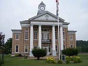
Wirt County is a county located in the state of West Virginia. Based on the 2010 census, the population was 5,717, making it the least
populous county in West Virginia. Its county seat is Elizabeth. The county was created in 1848 by the Virginia General Assembly and named for
US Attorney General and presidential candidate William Wirt. The county is serviced by one high school, Wirt County High School.
Wirt County is included in the Parkersburg-Vienna, WV Metropolitan Statistical Area, which is included in the Parkersburg-Marietta-Vienna,
WV-OH Combined Statistical Area.
Etymology - Origin of Wirt County Name
For William Wirt of Maryland, who gained fame as an author, orator and lawyer in his adopted state of Virginia
Demographics:
County QuickFacts: CensusBureau Quick Facts
Early History of Wirt County, West Virginia
Wirt County was created by an act of the Virginia General Assembly on January 19, 1848 from parts of Jackson and Wood counties. The county was named in honor of William Wirt (1772-1834).
William Wirt was born on November 8, 1772 in Bladensburg, Prince George County, Maryland. He was educated in Georgetown and was employed as a tutor as a young man. He studied the law and was admitted to the bar in 1792 at Culpepper Court House, Virginia. He later moved to Richmond and distinguished himself as an author, orator, and lawyer. In 1799, he was appointed the clerk of the Virginia House of Delegates, and, in 1802, he was appointed chancellor of the eastern judicial district. In 1803, his book "The Letters of a British Spy" was very well received and went through several editions. In 1807, he was appointed by President Thomas Jefferson to be one of the attorneys representing the United States in the trial of Vice-President Aaron Burr, accused of treason. In 1808, he served a single year in the West Virginia General Assembly. In 1816, he was appointed by President James Madison to the US District Attorney for Virginia and, in 1817, was named Madison's Attorney General of the United States. He held that position until 1829. He was one of the lawyers involved in the famous Gibbons vs. Ogden (1823) US Supreme Court case that held historic significance because it provided the federal government with broad powers over interstate as well as intrastate commerce. After Madison's two terms were completed in 1829, Wirt moved to Baltimore. He became active in the anti-Masonic political party and was their nominee for the Presidency in 1832. He received 33,108 popular votes and one electoral vote from the state of Vermont. He continued to write books, several of which were very popular. He died on February 18, 1834.
William Beauchamp (1743-1808) was the first settler in the county. He came to the area now called Elizabeth in 1796 and claimed 1,400 acres of land at Tuckers Riffle on the Little Kanawha River. He was a 53 year old farmer, a member of the Continental Navy during the American Revolutionary War and a lay minister in the Methodist Church. In 1803, he built the first grist mill in the county and his farm, known as Beauchamp's Mills, was laid out as a town in 1817. At that time, the town was named Elizabeth, in honor of his daughter, Elizabeth (Tavenner) Beauchamp. Elizabeth was named the county seat when the county was formed in 1848. Burning Springs was the destination of thousands of fortune seekers during the 1860s following the discovery of oil. In August of 1860 the "town" had fewer than 20 permanent residents. Six months later, over 6,000 fortune seekers crowded into the town. Hundreds of thousands of barrels of crude oil was produced there between 1860 and 1870. During the Civil War, Confederate cavalrymen, under the command of General William E. Jones, burned the town to the ground on May 9, 1863, along with all the oil in the town's storage tanks. 100,000 barrels of oil were ignited, and the light from the fire was clearly visible in the night sky as far away as Parkersburg, 42 miles away.
Geography: Land and Water
As reported by the Census Bureau, the county has a total area of 235 square miles (610 km2), of which 233 square miles (600 km2) is land and 2.3 square miles (6.0 km2) (1.0%) is water
Neighboring Counties
Bordering counties are as follows:
- Northeast: Ritchie County
- Northwest: Wood County
- South: Roane County
- Southeast: Calhoun County
- Southwest: Jackson County
Education


Click Image to Enlarge
