Physiographic Regions
Physiographic Regions of the lower 48 US States
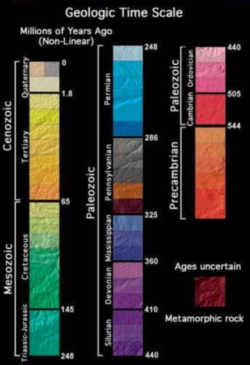
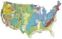
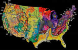
Geomorphic, or physiographic, regions are broad-scale subdivisions based on terrain texture, rock type and geologic structure and historyThe image presented here shows the topographic textures and generalized geology (by age) from which the physical regions were synthesized
A physiographic province is a landform region, an area delineated according to similar terrain that has been shaped by a common geologic history.
There are eight distinct physiographic divisions within the continental United States. Each is composed of smaller physiographic areas called provinces and sections respectively.
Eight Distinct Physiographic Divisions

- Laurentian Upland (area labeled 1) - part of the Canadian Shield that extends into the northern United States Great Lakes area.
- Atlantic Plain (2 and 3) - the coastal regions of the eastern and southern parts includes the continental shelf, the Atlantic Coast and the Gulf Coast.
- Appalachian Highlands (4-10) - lying on the eastern side of the United States, it includes the Appalachian Mountains, Adirondacks and New England province.
- Interior Plains (11-13) - part of the interior contentintal United States, it includes much of what is called the Great Plains.
- Interior Highlands (14 and 15)- also part of the interior contentintal United States, this division includes the Ozark Plateau.
- Rocky Mountain System (16-19) - one branch of the Cordilleran system lying far inland in the western states.
- Intermontane Plateaus (20-22) - also divided into the Columbia Plateau, the Colorado Plateau and the Basin and Range Province, it is a system of plateaus, basins, ranges and gorges between the Rocky and Pacific Mountain Systems. It is the setting for the Grand Canyon, the Great Basin and Death Valley.
- Pacific Mountain System (23-25)- the coastal mountain ranges and features in the west coast of the United States.
Physiographic Regions of the lower 48 US States
LAURENTIAN UPLAND
- Superior Upland
ATLANTIC PLAIN
- Continental Shelf
- Coastal Plain
- Embayed section
- Sea Island section
- Floridian section
- East Gulf Coastal Plain
- Mississippi Alluvial Plain
- West Gulf Coastal Plain
APPALACHIAN HIGHLANDS
- Piedmont province
- Piedmont Upland
- Piedmont Lowlands
- Blue Ridge province
- Northern section
- Southern section
- Valley and Ridge province
- Tennessee section
- Middle section
- Hudson Valley
- St. Lawrence Valley
- Champlain section
- Northern section
- Appalachian Plateaus province
- Mohawk section
- Catskill section
- Southern New York section
- Allegheny Mountain section
- Kanawha section
- Cumberland Plateau section
- Cumberland Mountain section
- New England Province
- Seaboard Lowland section
- New England Upland section
- White Mountain section
- Green Mountain section
- Taconic section
- Adirondack province
INTERIOR PLAINS
- Interior Low Plateaus
- Highland Rim section
- Lexington Plain
- Nashville Basin
- Central Lowland
- Eastern Lake section
- Western Lake section
- Wisconsin Driftless section
- Till Plains
- Dissected Till Plains
- Osage Plains
- Great Plains province
- Missouri Plateau, glaciated
- Missouri Plateau, unglaciated
- Black Hills
- High Plains
- Plains Border
- Colorado Piedmont
- Raton section
- Pecos Valley
- Edwards Plateau
- Central Texas section
INTERIOR HIGHLANDS
- Ozark Plateaus
- Springfield-Salem plateaus
- Boston "Mountains"
- Ouachita province
- Arkansas Valley
- Ouachita Mountains
ROCKY MOUNTAIN SYSTEM
- Southern Rocky Mountains
- Wyoming Basin
- Middle Rocky Mountains
- Northern Rocky Mountains
INTERMONTANE PLATEAUS
- Columbia Plateau
- Walla Walla Plateau
- Blue Mountain section
- Payette section
- Snake River Plain
- Harney section
- Colorado Plateaus
- High Plateaus of Utah
- Uinta Basin
- Canyon Lands
- Navajo section
- Grand Canyon section
- Datil section
- Basin and Range province
- Great Basin
- Sonoran Desert
- Salton Trough
- Mexican Highland
- Sacramento section
PACIFIC MOUNTAIN SYSTEM
- Cascade-Sierra Mountains
- Northern Cascade Mountains
- Middle Cascade Mountains
- Southern Cascade Mountains
- Sierra Nevada
- Pacific Border province
- Puget Trough
- Olympic Mountains
- Oregon Coast Range
- Klamath Mountains
- California Trough
- California Coast Ranges
- Los Angeles Ranges
- Lower California province
US Geography

Geography is a field of science dedicated to the study of the lands, the features, the inhabitants, and the phenomena of the Earth.


