


Click Image to Enlarge
Texas Counties
Texas is divided into two hundred and fifty-four counties, more than any other state. Texas was originally divided into municipalities, a unit of local government under Spanish and Mexican rule. When the Republic of Texas gained its independence in 1836, there were 23 municipalities, which became the original Texas counties. Many of these would later be divided into new counties. The most recent county to be created was Kenedy County in 1921. The most recent county to be organized was Loving County in 1931Cochran County, Texas
Cochran County Education, Geography, and History
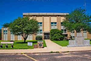
Cochran County is a county located in the state of Texas. Based on the 2010 census, its population was 3,127. The county seat is Morton. The county was created in 1876 and later organized in 1924. It is named for Robert E. Cochran, a defender of the Alamo
Etymology - Origin of Cochran County Name
Robert E. Cochran, a defender of the Alamo
Demographics:
County QuickFacts: CensusBureau Quick Facts
Cochran County History
Created in 1876, and still unorganized, Cochran County lies to the west of Hockley and its western boundary is New Mexico. Cochran is named for Robert E. Cochran, a defender of the Alamo. The seat of the county is Morton.
Handbook of Texas Online
In 1876 Cochran County was formed by the Texas legislature from land
previously assigned to Bexar and Young counties. It was a land of grass,
sand hills, mesquite, jackrabbits, coyotes, bison, and pronghorn antelope.
Until the 1920s, when farmers began to move into the area, the county's
economy was dominated by ranches; the huge XIT Ranch controlled
much of the land. In 1879 and 1880, the Capitol Reservation was surveyed,
and in 1885 its land title passed to the XIT, which covered about 3,000,000
acres of land in the region. In 1887 XIT manager A. G. Boyce
divided the XIT into seven divisions; Cochran County was within the
southernmost division (known as Las Casas Amarillas, or Yellow Houses). The
Yellow House division was used as the XIT's breeding range. More at
John Leffler, "COCHRAN COUNTY," Handbook of Texas Online (http://www.tshaonline.org/handbook/online/articles/hcc13),
accessed January 23, 2016. Uploaded on June 12, 2010. Published by the Texas State Historical Association.
Geography: Land and Water
As reported by the Census Bureau, the county has a total area of 775 square miles (2,008 km2). 775 square miles (2,008 km2) of it is land and less than 1 km2 (less than 1 sq mi) of it (0.01%) is water.
The surface is high and level, and while the county has no streams, and depends upon an underground water supply, the prairie grasses have
made this section a natural home for cattle. The few ranchmen in the county have small orchards and a small acreage under cultivation, and it
has been demonstrated that the staple crops and several varieties of fruits can be raised successfully.
Neighboring Counties
Bordering counties are as follows:
- Bailey County (north)
- Hockley County (east)
- Yoakum County (south)
- Lea County, New Mexico (southwest)
- Roosevelt County, New Mexico (northwest)
Education


Click Image to Enlarge
