


Click Image to Enlarge
Texas Counties
Texas is divided into two hundred and fifty-four counties, more than any other state. Texas was originally divided into municipalities, a unit of local government under Spanish and Mexican rule. When the Republic of Texas gained its independence in 1836, there were 23 municipalities, which became the original Texas counties. Many of these would later be divided into new counties. The most recent county to be created was Kenedy County in 1921. The most recent county to be organized was Loving County in 1931Randall County, Texas
Randall County Education, Geography, and History
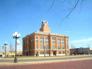
Randall County is a county located in the state of Texas. Based on the 2010 census, its population was 120,725. Its county seat is
Canyon. The county was created in 1876 and later organized in 1889. It is named for Horace Randal, a Confederate brigadier general killed at
the Battle of Jenkins Ferry. The reason the county name differs from his is because the bill creating the county misspelled Randal's name.
Randall County is part of the Amarillo, TX Metropolitan Statistical Area.
Etymology - Origin of Randall County Name
Horace Randal, a Confederate brigadier general who was killed at the Battle of Jenkins' Ferry (spelling differs due to an error in the bill creating the county)
Demographics:
County QuickFacts: CensusBureau Quick Facts
Randall County History
Randall County is a county located in the US state of Texas. Its seat is Canyon. Randall is named for Horace Randal, a Confederate brigadier general killed at the Battle of Jenkins Ferry. The reason the county name differs from his is because the bill creating the county misspelled Randal's name
Handbook of Texas Online
In the 1870s the slaughter of the buffalo and the battle of Palo Duro Canyon
drove the Plains Indians from the area and opened it up to settlement. Randall County was separated from Bexar
County in 1876 and named for Horace Randal, Confederate brigadier general killed
at the battle of Jenkins' Ferry, Arkansas, in 1864; a clerical error doubled the l in the name. Settlement
began in 1876 when Charles Goodnight drove 1,600 cattle into Palo Duro Canyon
and established his Old Home Ranch as the first JA Ranch headquarters. The
following year Leigh R. Dyer built his log ranch headquarters, the oldest
surviving building in the northern thirty-six counties of Texas, near the junction of Palo Duro and Tierra Blanca
creeks. In 1878 Dyer sold this property to the Gunter, Munson, and Summerfield firm, who established the GMS (later
T Anchor) Ranch at this site. Working with the Houston and Great Northern
Railroad on a partnership basis, the firm by 1880 controlled most of the land and all of the water sites in Randall
County. The county was unorganized from 1876 to 1889 and was attached successively to Jack County (1876-79), Wheeler
County (1879-81), Oldham County (1881-83), Donley County (1883-85), Oldham County again (1885-89), and Potter County
(1889). At first, county organization was contested by the big ranching element led by Lee John Hutson,
manager of the T Anchor, who sought to restrict the flow of homesteaders into the area. However, 200 petitioners led
by Lincoln G. Conner successfully arranged for an election, held in July 1889 at
Conner's dugout. Canyon City (later Canyon), which Conner had laid out earlier that year, was elected county seat,
with forty-five qualified voters participating. Six of the new county officers were T Anchor employees. The first
school in the county was taught in the fall of 1889 by Emma Turner at the old wooden shack that had served as a
courthouse. The county population rose from 187 in 1890 to 963 in 1900. All but one of the inhabitants in 1900 was
white, and only eighteen were foreign born. More at
H. Allen Anderson and Mark Odintz, "RANDALL COUNTY," Handbook of Texas Online (http://www.tshaonline.org/handbook/online/articles/hcr02),
accessed January 24, 2016. Uploaded on June 15, 2010. Published by the Texas State Historical Association.
Geography: Land and Water
As reported by the Census Bureau, the county has a total area of 922 square miles (2,389 km2), of which, 914
square miles (2,368 km2) of it is land and 8 square miles (21 km2) of it (0.87%) is water.
Palo Duro Canyon, the second largest canyon in the United States, is located in Randall County.
Neighboring Counties
Bordering counties are as follows:
- Potter County (north)
- Armstrong County (east)
- Swisher County (south)
- Castro County (southwest)
- Deaf Smith County (west)
Education


Click Image to Enlarge
