


Click Image to Enlarge
Texas Counties
Texas is divided into two hundred and fifty-four counties, more than any other state. Texas was originally divided into municipalities, a unit of local government under Spanish and Mexican rule. When the Republic of Texas gained its independence in 1836, there were 23 municipalities, which became the original Texas counties. Many of these would later be divided into new counties. The most recent county to be created was Kenedy County in 1921. The most recent county to be organized was Loving County in 1931Shackelford County, Texas
Shackelford County Education, Geography, and History
Shackelford County is a county located in the state of Texas. Based on the 2010 census, its population was 3,378. Its county seat is Albany. The county was created in 1858 and later organized in 1874. Shackelford is named for Dr. Jack Shackelford, a Virginia physician who equipped soldiers at his own expense to fight in the Texas Revolution.
Etymology - Origin of Shackelford County Name
Shackelford is named for Dr. John Shackelford, a Virginia physician who equipped soldiers at his own expense to fight in the Texas Revolution. Shackelford outfitted his troops in red uniforms, and they came to be called the "Shackelford Reds." Historic Fort Griffin, established in 1867, lies within Shackelford County.
Demographics:
County QuickFacts: CensusBureau Quick Facts
Shackelford County History
The county was created in 1858 and later organized in 1874. Its county seat is Albany. The county is northeast of Abilene, the seat of Taylor County. Shackelford is named for Dr. John Shackelford.
Handbook of Texas Online
Below the hill on which Fort Griffin was constructed, the civilian community of Fort Griffin, commonly called the
Flat or Hidetown, developed. This community served as a marketplace and supply point for buffalo
hunters and as a watering place for soldiers, hunters, and trail hands driving cattle over the Western Trail,
which crossed the Clear Fork nearby. The combination of buffalo hunters, soldiers, and cowboys, mixed with Indians
from the nearby Tonkawa camp, was volatile, and law enforcement was erratic. The long trip to the county court in
Jack County to do jury duty or deal with legal matters was hazardous; so in 1874 residents of the area petitioned
the county court of Jack County for permission to organize their own county. The new county was named in honor of
Dr. Jack Shackelford, a Texas revolutionary hero. Fort Griffin became the
temporary county seat on October 12, 1874. On November 8 of that year the founders of the county called an election
to determine the permanent location, and thus Albany-named by William R. Cruger
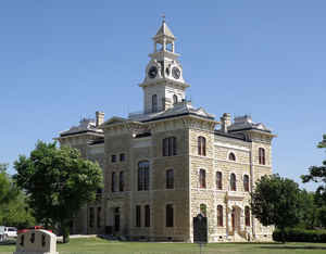
for his hometown, Albany, Georgia-was founded. In 1884 the county finished construction of a courthouse, built of
limestone quarried a few miles southwest of Albany. The structure still functions in its original capacity, and in
1962 was recorded as a Texas Historical Landmark. The county's population peaked at 6,695 in 1930, dropped to 3,323
by 1970, then climbed back to the 1980 figure of 3,915. Of the 1980 population 3,761 were white (including 211
Hispanics), 36 black, 6 Indian (in 1884 the federal government moved the Tonkawa Indians to Indian Territory), 4
Asian, and 108 of other origins. Of these residents, 2,450 lived in Albany; the remainder were in Lueders (which is
partly in Jones County), Moran, and Spring Creek, or on farms and ranches. In 1990 Shackelford County had 3,316
inhabitants More at
Frank Beesley, "SHACKELFORD COUNTY," Handbook of Texas Online (http://www.tshaonline.org/handbook/online/articles/hcs08),
accessed January 24, 2016. Uploaded on June 15, 2010. Published by the Texas State Historical Association.
Geography: Land and Water
As reported by the Census Bureau, the county has a total area of 916 square miles (2,371 km2), of which, 914
square miles (2,367 km2) of it is land and 2 square miles (4 km2) of it (0.17%) is water.
Neighboring Counties
Bordering counties are as follows:
- Throckmorton County (north)
- Stephens County (east)
- Eastland County (southeast)
- Callahan County (south)
- Jones County (west)
- Haskell County (northwest)
Education
Shackelford County includes these school districts:
Lueders-Avoca Independent School District
Albany Independent School District
Moran Independent School District


Click Image to Enlarge
