


Click Image to Enlarge
Texas Counties
Texas is divided into two hundred and fifty-four counties, more than any other state. Texas was originally divided into municipalities, a unit of local government under Spanish and Mexican rule. When the Republic of Texas gained its independence in 1836, there were 23 municipalities, which became the original Texas counties. Many of these would later be divided into new counties. The most recent county to be created was Kenedy County in 1921. The most recent county to be organized was Loving County in 1931Upshur County, Texas
Upshur County Education, Geography, and History
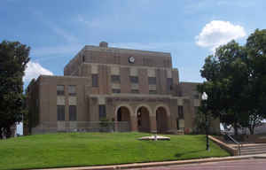
Upshur County is a county located in the eastern part of the state of Texas. Based on the 2010 census, the population was 39,309. The county
seat is Gilmer. The county is named for Abel P. Upshur who was US Secretary of State during President John Tyler's administration.
Upshur County is part of the Longview, Texas Metropolitan Statistical Area as well as the Longview-Marshall, TX Combined Statistical Area.
Etymology - Origin of Upshur County Name
Abel Parker Upshur, the fifteenth secretary of state of the United States who was killed in 1844 when a new Naval gun exploded during a demonstration aboard the USS Princeton on the Potomac (the county seat, Gilmer, was named for Capt. Thomas W. Gilmer, United States Secretary of the Navy who was also killed in the same explosion)
Demographics:
County QuickFacts: CensusBureau Quick Facts
Upshur County History
Humans have inhabited what is now Upshur county since at least 10,000 years ago. The Caddoan people lived in this
area, but were driven out about 1750, probably due to losses from new infectious diseases.
Later some Cherokee migrated to the area from their territories in the Southeast - Georgia and Alabama. The Cherokee were driven out of here
by European-American settlers in 1839, after having been removed from the Southeast.
The first European-American settler in Upshur county was probably Isaac Moody, who settled there in 1836.
On April 27, 1846, after Texas was admitted to the Union, the first legislature of the state of Texas established Upshur County; at that time
the county included the area of present Camp County and part of modern Gregg County. On May 1, 1848, the county's voters chose the location
for Gilmer, the county seat, and in August the sale of blocks and lots in the new town began. Upshur County was named for Abel Parker Upshur,
Secretary of State under John Tyler The county seat is Gilmer.
Handbook of Texas Online
Artifacts dating from the Paleo-Indian period have been found in Upshur County, indicating that humans have lived
in the area for perhaps 10,000 to 12,000 years. Caddoan Indian groups lived in the region during the Late
Prehistoric period (1,150 to 250 years ago), but by the 1690s most of the Caddoans had disappeared, probably the
victims of disease epidemics. By the 1820s and 1830s Cherokees had crossed into the area as they traveled from
Oklahoma toward Nacogdoches using the route called the Cherokee Trace. By 1839, when the Cherokees were expelled
from Texas, the area that is now Upshur County was at the intersection of two early immigration routes: the Cherokee
Trace and the Jefferson-Dallas Road, which ran across the northern portion of the area. The first settler within the
limits of modern Upshur County was probably Isaac Moody, who settled on the Cherokee Trace near West Mountain in
1836. The area that is now Upshur County was originally part of Nacogdoches County and later was incorporated into
Harrison County. On April 27, 1846, after Texas was admitted to the Union, the first legislature of the state of
Texas established Upshur County; at that time the county included the area of present Camp County and part of modern
Gregg County. On May 1, 1848, the county's voters chose the location for Gilmer, the county seat, and in August the
sale of blocks and lots in the new town began. Some of the earliest residents had been participants in the
Regulator-Moderator War. John Hamilton McNairy,
for example, signed the treaty that ended the war as a representative of the Regulators; in 1847 he bought land near
Coffeeville and moved to Upshur County. McNairy was elected the first representative from the new county to the
Texas legislature. Analysis of the 1850 and 1860 United States Census returns demonstrates that almost equal numbers
of Tennesseans and Alabamans moved to the county during its early period. Planters from the Deep South tended to
concentrate in the eastern half of the county, using their slaves to open up large tracts of land and to produce
cotton. Meanwhile, farmers from the upper south who owned no slaves tended to settle in the western section of the
county; they operated smaller, self-sustaining family farms and often lived in log cabins. One of the oldest
churches in the county, the Enon Baptist Church of the Missionary Baptist Association, was organized on May 13,
1848; in 1849 the Hopewell Methodist Church organized and constructed its first building. Meanwhile other
communities had begun to grow, including Ashland, Lafayette, and Shady Grove. By 1850 there were 3,934 people,
including 682 slaves, living in Upshur County. According to the agricultural census for that year, local farmers
produced 31,000 bushels of corn, 673 400-pound bales of cotton, and 1,061 pounds of tobacco, along with smaller
amounts of wheat, rice, and oats. As the county grew and prospered, new social institutions evolved, and by the
mid-1850s schools such as the Gilmer Masonic Female Institute, the Murray Institute, and the Gilmer Male Academy had
been established. By 1860 the population had increased to 10,645, including 3,794 slaves. That year 404,000 bushels
of corn and 8,000 bales of cotton were produced, and 11,000 cattle were also reported in the area. Lumbering was
another important part of the local economy, and by the beginning of the Civil War
there were ten to twelve water-powered lumber mills operating in the county. More at
Mary Laschinger Kirby, "UPSHUR COUNTY," Handbook of Texas Online (http://www.tshaonline.org/handbook/online/articles/hcu01),
accessed January 24, 2016. Uploaded on June 15, 2010. Published by the Texas State Historical Association.
Geography: Land and Water
As reported by the Census Bureau, the county has a total area of 593 square miles (1,535 km2), of which, 588
square miles (1,522 km2) of it is land and 5 square miles (13 km2) of it is water. The total area is 0.85% water.
Neighboring Counties
Bordering counties are as follows:
- Camp County (north)
- Morris County (northeast)
- Marion County (east)
- Harrison County (southeast)
- Gregg County (south)
- Smith County (southwest)
- Wood County (west)
Education
The following school districts serve Upshur County: Big Sandy ISD (partly in Wood County), Gilmer ISD (small portion in Camp County), Gladewater ISD (mostly in Gregg County, partly in Smith County), Harmony ISD (partly in Wood County), New Diana ISD (small portion in Harrison County), Ore City ISD (small portion in Harrison, Marion counties), Pittsburg ISD (mostly in Camp County, small portion in Wood County), Union Grove ISD, and Union Hill ISD (mostly in Upshur County,partly in Wood County)


Click Image to Enlarge
