


Click Image to Enlarge
Arkansas Counties
The first of the Arkansas' seventy-five present-day counties created, Arkansas County was formed on 13 December 1813, when this area was part of the Missouri Territory.Baxter County, Arkansas
Baxter County Education, Geography, and History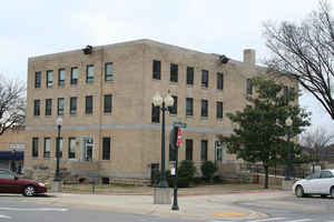
Baxter County is a county in the state of Arkansas. Based on the 2010 census, the county's
population was 41,513. The county
seat is
Mountain Home. It is Arkansas's 66th county, formed on March 24, 1873.
Baxter county was named for Elisha Baxter, the tenth governor of Arkansas.
The Mountain Home, AR, Micropolitan Statistical Area includes all of Baxter County. It is in the northern part of the state, bordering
Missouri. It is commonly referred to as the Twin Lakes Area because it is bordered by two of Arkansas' largest lakes, Bull Shoals Lake and
Norfork Lake. On its southern border is the Norfork Tailwater and the Buffalo National River.
Etymology - Origin of Baxter County Name
Baxter is named for Elisha Baxter, the thirteenth governor of Arkansas. Elisha Baxter (September 1, 1827 - May 31, 1899) was a Republican Governor of the State of Arkansas.
Demographics:
County QuickFacts: CensusBureau Quick Facts
Baxter County History
Baxter county was created on March 24, 1873, from parts of Fulton, Izard, Marion, and Searcy counties, and was named for Elisha Baxter, then Governor of Arkansas. Mountain Home is the county seat. The third floor rooms of the courthouse were added between 1908 and 1912 to give a third floor because the previous courthouse only had two stories, and in the early nineteen hundreds another thriving town in Baxter County was trying to get to be the county seat, therefore the Arkansas Legislature passed an Act requiring the courthouse to have three stories; thus, a third story was built in a hurry. The courthouse is located fourteen miles from the oldest courthouse in Arkansas, the log house of Major Wolfe, built in 1809 and still standing at the town of Norfolk. Over the past three decades, the population of Baxter County has boomed. Much of the county's growth and more than half its tax dollars can be traced to tourism and retirement. Visitors often return to take up residence. Other resources include a technical campus of Arkansas State University and a fine regional medical center located in Mountain Home.
Geography: Land and Water
As reported by the Census Bureau, the county has a total area of 587 square miles (1,520 km2), of which 554 square miles (1,430 km2) is land and 32 square miles (83 km2) (5.5%) is water.
The landscape of Baxter County is rocky and mountainous. The county courthouse sits between two of the state's largest lakes, Bull Shoals and Norfolk.
The county has a large water-base recreation such as the White River, North Fork River, Lake Norfork, Bull Shoals Lake and the Buffalo National River.
Neighboring Counties
Bordering counties are as follows:
- North: Ozark County, Mo.
- East: Fulton County
- Southeast: Izard County; Stone County
- Southwest: Searcy County
- West: Marion County
Education


Click Image to Enlarge
