


Click Image to Enlarge
Arkansas Counties
The first of the Arkansas' seventy-five present-day counties created, Arkansas County was formed on 13 December 1813, when this area was part of the Missouri Territory.Benton County, Arkansas
Benton County Education, Geography, and History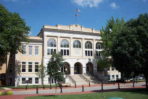
Benton County is a county located in the state of Arkansas. Based on the 2010 census, the
population was 221,339, making it the
second-most populous county in Arkansas. The county
seat is Bentonville. The county was formed on September
30, 1836. Benton county was named after Thomas Hart
Benton, a US Senator from Missouri.
Benton County is part of the Fayetteville-Springdale-Rogers, AR-MO Metropolitan Statistical Area.
Etymology - Origin of Benton County Name
Benton is named for Thomas Hart Benton, an US Senator from Missouri. Thomas Hart Benton nicknamed "Old Bullion" (March 14, 1782 - April 10, 1858), was a US Senator from Missouri and a staunch advocate of westward expansion of the United States. He served in the Senate from 1821 to 1851, becoming the first member of that body to serve five terms. Benton was an architect and champion of westward expansion by the United States, a cause that became known as Manifest Destiny.
Demographics:
County QuickFacts: CensusBureau Quick Facts
Benton County History
Benton county was created in 1836, was named after United States Senator Thomas Hart Benton of Missouri. The Courthouse is located on the square in Bentonville, the site of Arkansas's most significant Civil War battle at Pea Ridge. Mementos of Confederate heroes are located throughout the courthouse. The county, historically a fruit-growing center, has a diversified economy that includes agriculture, especially dairy and poultry. From the corporate headquarters of Wal-Mart, the fastest growing retail chain in America, to Little Debbie bakeries, Cooper Communities', and Bella Vista retirement community to light manufacturing, business is booming in Benton County. The population of Benton County doubled from 1950 to 1980 and at the last census (1990), had increased another 25%. Orchards and pastures, museums and art galleries, dogwood tours in the fall, arts and crafts fairs, country music, symphony concerts, and a community theater are all popular with the local people as well as visitors.
In 2012, Benton County voters elected to make the county wet, or a non-alcohol prohibition location.
Geography: Land and Water
As reported by the Census Bureau, the county has a total area of 884 square miles (2,290 km2), of which 847 square miles (2,190 km2) is land and 37 square miles (96 km2) (4.1%) is water. Most of the water is in Beaver Lake.
The landscape of the county is gently sloping hills. Benton County's natural resources are as varied as its economy. Beaver Lake offers fishing and water recreation.
Neighboring Counties
Bordering counties are as follows:
- Northeast: Barry County, Mo.
- East: Carroll County
- Southeast: Madison County
- South: Washington County
- Southwest: Adair County, Okla.
- West: Delaware County, Okla.
- Northwest: McDonald County, Mo.
Education


Click Image to Enlarge
