


Click Image to Enlarge
Arkansas Counties
The first of the Arkansas' seventy-five present-day counties created, Arkansas County was formed on 13 December 1813, when this area was part of the Missouri Territory.Boone County, Arkansas
Boone County Education, Geography, and History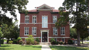
Boone County is a county located in the state of Arkansas. Based on the 2010 census, the
population was 36,903. The county
seat is
Harrison. This county was formed on April 9, 1869.
Boone county is named for Daniel Boone, the famous
frontiersman.
Boone County is part of the Harrison, AR Micropolitan Statistical Area.
Etymology - Origin of Boone County Name
Boone is named for Daniel Boone, the famous frontiersman. Daniel Boone was an American pioneer and hunter whose frontier adventures made him one of the first folk heroes of the United States. Boone is most famous for his exploration and settlement of what is now the state of Kentucky, which was then beyond the western borders of the Thirteen Colonies. Despite resistance from American Indians, for whom Kentucky was a traditional hunting ground, in 1775 Boone blazed the Wilderness Road through the Cumberland Gap and into Kentucky. There he founded Boonesborough, one of the first English-speaking settlements beyond the Appalachian Mountains. Before the end of the 18th century, more than 200,000 people entered Kentucky by following the route marked by Boone.
Demographics:
County QuickFacts: CensusBureau Quick Facts
Boone County History
Boone county was created on April 9, 1869, the 63rd county in Arkansas and one of the first to be formed after the Civil War. Harrison, the county seat, has been rated by Rand McNally's Places Rated Retirement Guide as one of the Top 10 most ideal retirement spots in the country for climate and terrain, housing, affordability, low crime, health-care facilities, and recreational opportunities. Harrison is the county seat where the stately courthouse building is located. One of the most unusual monuments on any courthouse lawn in the state stands on this courthouse lawn, a large granite memorial to the 140 Arkansawyers who left from near Harrison to settle in California and all of whom, except for seventeen small children, were killed in the Mountain Meadows Massacre in Utah in 1857. Once a zinc and lead mining area, Boone County depends more now on cattle and timber as its economic base. Shops featuring Ozark handmade arts and crafts, restaurants, home-style cured meats, and mountain cooking are dotted along Scenic Highway 7 that stretches through Boone County. Both Bull Shoals and Table Rock lakes are well known for fishing and camping and picturesque Crooked Creek, an Ozark Mountain stream, is noted for its excellent smallmouth bass fishing.
Geography: Land and Water
As reported by the Census Bureau, the county has a total area of 602 square miles (1,560 km2), of which 590 square miles (1,500 km2) is
land and 12 square miles (31 km2) (1.9%) is water. The county is located in the northwest portion of the state, and borders Missouri to the
north.
The county lies entirely within the Ozark Mountains. The landscape of
the county is flat-topped mountains and rugged terrain of the Ozark
Mountains. Rolling hills characterize the topography, with the more rugged Boston Mountains lying
just to the south. Isolated peaks of the Boston Mountain range are found in the south, including Boat Mountain, Pilot's Knob, and Gaither
Mountain. Portions of Bull Shoals Lake and Table Rock Lake lie in the northeast and northwest corners, respectively. The Corps of Engineers
operates and maintains popular campsites on the lakes at Lead Hill and Cricket Creek. Crooked Creek, popular with bass fishermen, winds
through the county from south to east. Both Bull Shoals and Table Rock
lakes are well known for fishing and camping and picturesque Crooked
Creek, an Ozark Mountain stream, is noted for its excellent smallmouth
bass fishing.
Neighboring Counties
Bordering counties are as follows:
- North: Taney County, Mo.
- East: Marion County
- Southeast: Searcy County
- Southwest: Newton County
- West: Carroll County
Education


Click Image to Enlarge
