


Click Image to Enlarge
Arkansas Counties
The first of the Arkansas' seventy-five present-day counties created, Arkansas County was formed on 13 December 1813, when this area was part of the Missouri Territory.Cross County, Arkansas
Cross County Education, Geography, and History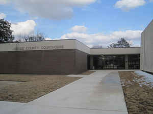
Cross County is a county located in the state of Arkansas. Based on the 2010 census, the population was 17,870. The county seat is Wynne. Cross County is Arkansas's 53rd county, formed on November 15, 1862. Cross county is named for Confederate Colonel David C. Cross, a political leader in the area.
Etymology - Origin of Cross County Name
Cross county is named for David C. Cross, a Confederate soldier and political leader in the region.
Demographics:
County QuickFacts: CensusBureau Quick Facts
Cross County History
Cross county was created on November 15, 1862 from parts of Crittenden, Poinsett, and St. Francis counties. The county it was named for Colonel David Cross, a Confederate officer. Cross County has rich, flat delta farmland in the east and west and rolling hills in the center. Agriculture and related enterprises are major to the county with rice bringing in more than half the county's revenues. Soybeans and cotton are other main crops while peaches and other fruit crops are predominate on Crowley's Ridge. Village Creek State Park, almost 7,000 acres on Crowley's Ridge, has two fishing lakes, hiking trails, campsites, picnic sites, playgrounds, and many recreational areas, and is a poplar tourist area. The county seat is Wynne. The courthouse courtroom is unique in that the building is arranged so that jurors sit with their backs to the spectators, focusing their attention on the judge and witness, who sit in opposite corners at the front of the room. Tourism is on the rise in Cross County.
Geography: Land and Water
As reported by the Census Bureau, the county has a total area of 622 square miles (1,610 km2), of which 616 square miles (1,600 km2) is land and 5.9 square miles (15 km2) (1.0%) is water.
The landscape of Craighead County is flat, fertile farmland with rolling hills with Crowley's Ridge in the center. The Wittsburg Natural Area preserves a good sample of Crowley's Ridge covered with beech and sugar maple trees, spring wildflowers, and the state's only natural distributions of tulip trees and pennywort.
Neighboring Counties
Bordering counties are as follows:
- Northeast: Poinsett County
- East: Crittenden County
- South: St. Francis County
- Southwest: Woodruff County
- Northwest: Jackson County
Education


Click Image to Enlarge
