


Click Image to Enlarge
Arkansas Counties
The first of the Arkansas' seventy-five present-day counties created, Arkansas County was formed on 13 December 1813, when this area was part of the Missouri Territory.Independence County, Arkansas
Independence County Education, Geography, and History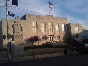
Independence County is a county located in the state of Arkansas. Based on the 2010 census, the
population was 36,647. The county
seat is
Batesville. Independence County is Arkansas's ninth county, formed on October 20, 1820, from a portion of Lawrence County.
The county is named in commemoration of the Declaration
of Independence.
The Batesville, AR Micropolitan Statistical Area includes all of Independence County.
Etymology - Origin of Independence County Name
Independence county is named for the United States Declaration of Independence. The United States Declaration of Independence is a statement adopted by the Continental Congress on July 4, 1776, announcing that the thirteen American colonies then at war with Great Britain were no longer a part of the British Empire. Written primarily by Thomas Jefferson, the Declaration is a formal explanation of why Congress had voted on July 2 to declare independence from Great Britain, more than a year after the outbreak of the American Revolutionary War. The birthday of the United States of America- Independence Day- is celebrated on July 4, the day the wording of the Declaration was approved by Congress.
Demographics:
County QuickFacts: CensusBureau Quick Facts
Independence County History
Independence county was formed on October 1820 from part of Lawrence County, in which its name comes from the Declaration of Independence. The county seat is Batesville. Agriculture is the economic base of the county, primarily is cattle and poultry production and processing. Some manufacturing is located near Batesville. White river brought settlers to the county in the early 1800's. The Pioneer Cemetery is the oldest recognized and preserved cemetery in Arkansas. During the Arkansas Sesquicentennial, a three-foot tall bell made in 1858 for the courthouse was permanently installed in a specially designed limestone structure on the courthouse lawn. Similar limestone from Batesville was used to build the State Capitol. Batesville has one college, Lyon College, a private Christian college established in 1872. The college has an annual Ozark Scottish Festival & Highland Games each year that attracts many visitors to the area. It is an alcohol prohibition or dry county.
Geography: Land and Water
As reported by the Census Bureau, the county has a total area of 772 square miles (2,000 km2), of which 764 square miles (1,980 km2) is land and 7.6 square miles (20 km2) (1.0%) is water.
The landscape of the county is rolling hills, foothills of the Ozarks, except for river delta farmland in the southeast section. The scenic White River coming into Batesville has the typical Ozark bends, riffles, shoals and pools surrounded by forest, rock, and hillsides. It is famous for its excellent trout fishing. When it leaves Batesville, it becomes mostly a flatland river.
Neighboring Counties
Bordering counties are as follows:
- North: Sharp County
- Northeast: Lawrence County
- Southeast: Jackson County
- Southwest: White County; Cleburne County
- West: Stone County
- Northwest: Izard County
Education


Click Image to Enlarge
