


Click Image to Enlarge
Arkansas Counties
The first of the Arkansas' seventy-five present-day counties created, Arkansas County was formed on 13 December 1813, when this area was part of the Missouri Territory.Lonoke County, Arkansas
Lonoke County Education, Geography, and History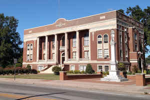
Lonoke County is a county located in the Central Arkansas region of the US state of Arkansas. Based on the 2010 census, the population was 68,356, making it the eleventh-most populous of Arkansas's seventy-five counties. The county seat is Lonoke and largest city is Cabot. Lonoke County was formed on April 16, 1873 from Pulaski County and Prairie County. The county is named after a large red oak, that stood on the site of the present county seat, that had been used by a surveyor to lay out the Memphis and Little Rock Railroad.
Etymology - Origin of Lonoke County Name
Lonoke county is named for a "lone oak" tree that stood on the site of the present county seat and was used as a local landmark.
Demographics:
County QuickFacts: CensusBureau Quick Facts
Lonoke County History
This is the only county in Arkansas whose county seat bears the same name, named by a railroad surveyor that used a massive red oak tree as a landmark. Lonoke County was established on April 16, 1873. The County is still a primarily agricultural county. The Joe Hogan Fish Hatchery, the Smoke Hold Natural Area, Toltec Mounds State Park, and Camp Nelson Confederate Park are areas of interest in the County. The Lonoke County Courthouse was built in 1928. This building is the third courthouse we have had due to fire and rebuilding. The Lonoke County Courthouse Square is located at 301 North Center Street in the City of Lonoke.
Geography: Land and Water
As reported by the Census Bureau, the county has a total area of 803 square miles (2,080 km2), of which 771 square miles (2,000 km2) is land and 32 square miles (83 km2) (4.0%) is water.
Located within Central Arkansas, the county's varied geography can be roughly broken into thirds horizontally. The top third has rolling hills at the edge of the Ozarks, including the Cabot area. The middle third, including the Lonoke area, contains portions of the Grand Prairie, a flat native grassland today known for rice farming, an important part of the culture, economy and history of Lonoke County. The southern third, including the Scott area, is home to the alluvial soils of the Arkansas Delta.
Neighboring Counties
Bordering counties are as follows:
- North: White County
- Northeast: Prairie County
- Southeast: Arkansas County
- South: Jefferson County
- West: Pulaski County
- Northwest: Faulkner County
Education


Click Image to Enlarge
