


Click Image to Enlarge
Arkansas Counties
The first of the Arkansas' seventy-five present-day counties created, Arkansas County was formed on 13 December 1813, when this area was part of the Missouri Territory.Poinsett County, Arkansas
Poinsett County Education, Geography, and History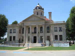
Poinsett County is a county located
in the US state of Arkansas. Based on the 2010 census, the
population was 24,583. The county seat
is Harrisburg. Poinsett county was created on February
28, 1838, from parts of Greene and St. Francis counties. The county is
named for Joel Roberts Poinsett, an United States
Secretary of War and namesake of the poinsettia.
Poinsett County is included in the Jonesboro, AR Metropolitan
Statistical Area.
Etymology - Origin of Poinsett County Name
Poinsett county is named for Joel Roberts Poinsett, an United States Secretary of War and namesake of the poinsettia. Joel Roberts Poinsett (March 2, 1779 - December 12, 1851) was a physician, botanist and American statesman. He was a member of the United States House of Representatives, the first United States Minister to Mexico (the United States did not appoint ambassadors until 1896), a US Secretary of War under Martin Van Buren and a cofounder of National Institute for the Promotion of Science and the Useful Arts (a predecessor of the Smithsonian Institution), as well as the namesake of Poinsett County, Arkansas, the historic Poinsett Bridge in Greenville County, South Carolina, Poinsett State Park in Sumter County, South Carolina, and the poinsettia, a popular Christmas flower.
Demographics:
County QuickFacts: CensusBureau Quick Facts
Poinsett County History
Poinsett county was created on February 28, 1838, from parts of Greene and St. Francis counties, in which the county was named after Joel Roberts Poinsett. He was a diplomat, statesman and competent amateur botanist. The county seat is Harrisburg. Crowley's Ridge splits the county. East of the ridge is cotton and soybeans and west of the ridge is rice. Along the ridge are beef and dairy cattle. The economic base of the county is agricultural. The St. Francis Sunken Lands Wildlife Management Area features hunting on sunken lands that were created by the New Madrid earthquakes of 1811 and 1812, that sank the land between 15 to 20 feet in places, destroying the St. Francis River's channel and creating the St. Francis swamps and the Sunken Lands. After the earthquakes the federal government instituted its first "Disaster Relief Fund" by issuing New Madrid Certificates entitling displaced landowners to new acreage in the Louisiana Purchase Territory. Lake Poinsett, Lake Poinsett State Park, Lake Hogue, and Bayou Deview Wildlife Management area all offer fishing, hunting and other water activities. A unique feature of Poinsett County is the sight of one river running under another. The Riverdale Tunnel carries the Buffalo Ditch under the water of the left hand chute, a branch of the river. Many visitors enjoy the waters and wildlife of this area. The courthouse building is constructed mainly of Bedford stone, although the large columns on the east and west entrances, as well as the other columns and accents, are sandstone. The courtyard is enclosed by evergreen privet shrub. The tower clock has four faces and the tower-arches and brass trim accents the red tile roof. The date of construction in Roman numerals is inscribed over both entries: MCMXVIII.'
Geography: Land and Water
As reported by the Census Bureau, the county has a total area of 764 square miles (1,980 km2), of which 758 square miles (1,960 km2) is land and 5.2 square miles (13 km2) (0.7%) is water.
Located in Arkansas's northeast corner, the county is bisected by Crowley's Ridge and the L'Anguille River which both pass north-south through the county. The landscape of the county is rich, flat, delta farmland in the east and west and rolling hills in the center of the county. The soils in the eastern part of the county have been deposited by the Mississippi River and are mostly used for cotton farming. Western Poinsett County is generally dedicated to rice fields. Lake Poinsett State Park is centrally located within the county.
Neighboring Counties
Bordering counties are as follows:
- North: Craighead County
- Northeast: Mississippi County
- Southeast: Crittenden County
- Southwest: Cross County
- West: Jackson County
Education
Public education
Early childhood, elementary and secondary education is available from four school districts listed from largest to smallest based on student population:
- Trumann School District based in Trumann with four facilities serving more than 1,600 students.
- Harrisburg School District based in Harrisburg with five facilities and serving more than 1,300 students.
- East Poinsett County School District based in Lepanto with three facilities serving more than 750 students.
- Marked Tree School District based in Marked Tree with three facilities serving more than 650 students.
Libraries
Poinsett County is served with central and branch libraries from two library systems, the Crowley Ridge Regional Library System and Trumann Library System.


Click Image to Enlarge
