


Click Image to Enlarge
Arkansas Counties
The first of the Arkansas' seventy-five present-day counties created, Arkansas County was formed on 13 December 1813, when this area was part of the Missouri Territory.Randolph County, Arkansas
Randolph County Education, Geography, and History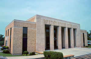
Randolph County is a county located in the state of Arkansas. Based on the 2010 census, the population was 17,969. The county seat is Pocahontas. Randolph County is Arkansas's 32nd county, formed on October 29, 1835. Randolph county is named for John Randolph, a US senator from Virginia, who was influential in obtaining congressional approval of the Louisiana Purchase, of which Randolph County is a part.
Etymology - Origin of Randolph County Name
Randolph county is named for John Randolph of Roanoke, a US congressman from Virginia. John Randolph (June 2, 1773 - May 24, 1833), known as John Randolph of Roanoke, was a leader in Congress from Virginia and spokesman for the "Old Republican" or "Quids" faction of the Democratic-Republican Party that wanted to restrict the federal government's roles.
Demographics:
County QuickFacts: CensusBureau Quick Facts
Randolph County History
Randolph county was formed on October 29, 1835, by the last Territorial Legislature from part of Lawrence County, in which Randolph County was named after John Randolph, a Virginia statesman who claimed to be a descendant of the famous Indian Princess Pocahontas. The county seat is Pocahontas. The economic base of the county is agricultural with soybeans and grains the principal crops in the delta and cattle ranching in the hill country. Small manufacturers have also added to the economy. Five rivers crisscross through the county, the spring, Black, Current, Fourche, and Eleven Point that makes good fishing and water recreation. Old Davidsonville State Park features the site of Arkansas' first post office (1817), and first federal land office (1820), and first courthouse (1815). The Randolph County courthouse is Victorian, Italianate architecture and has a large aluminum seal of the State of Arkansas over the main entry door behind large square fluted concrete columns. The foyer, which runs across the front of the building, contains three large oil paintings depicting aspects of Arkansas history: one is of Indians, another of the Civil War, and the third, which shows road building, includes an old Studebaker wagon. This courthouse faces a sunken garden with benches, landscaped shrubs, and several lampposts for night illumination. Approached by means of imposing steps forty-eight feet wide, the garden dramatizes the view of the hill on which the original 1872 courthouse still stands. Randolph County is currently an alcohol prohibition or dry county.
Geography: Land and Water
As reported by the Census Bureau, the county has a total area of 656 square miles (1,700 km2), of which 652 square miles (1,690 km2) is land and 3.8 square miles (9.8 km2) (0.6%) is water.
The landscape of the county is Ozark Mountain foothills with the rich, delta farmland in the extreme southeast. It is said that Randolph County stands with one foot in the hills and one in the rich soil of the delta.
Neighboring Counties
Bordering counties are as follows:
- Northeast: Ripley County, Mo.
- East: Clay County
- Southeast: Greene County
- South: Lawrence County
- Southwest: Sharp County
- Northwest: Oregon County, Mo.
Education


Click Image to Enlarge
