


Click Image to Enlarge
Colorado Counties
Colorado currently has sixty-four counties. In February 1866, the first new county, Las Animas, was created. Alamosa was created in 1913, and in 2001, Broomfield was recognized as a city-county, bringing a total of 64 counties.Bent County, Colorado
Bent County Education, Geography, and History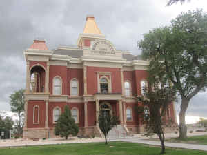
Bent County is one of the 64 counties of the state of Colorado. Based on the 2010 census, the population was 6,499. The county seat and only incorporated municipality is Las Animas. Bent County was created on February 6, 1874 from Huerfano County and former Cheyenne and Arapaho tribal land. The county is named in honor of frontier trader William Bent.
Etymology - Origin of Bent County Name
Bent County is named in honor of frontier trader William Bent.
Demographics:
County QuickFacts: CensusBureau Quick Facts
Bent County History
Bent County was created by the Colorado legislature on February 6, 1874, when Greenwood County, created only four years earlier, was dissolved and divided between Bent and Elbert counties. At the time of its creation, it included a large portion of southeastern Colorado. In 1889, Bent County acquired its current borders when it lost much of its territory to the newly created Cheyenne, Lincoln, Kiowa, Otero, and Prowers counties.
Spain sent out expeditions from Mexico City in the 1600's and discovered Indian settlements
around current day Bent County boundaries. The Spanish named the Indians collectively as Apache.
The first recorded French explorers were the 1739 expeditions of the Mallet brothers. French influence
on the area grew as several more French expeditions were made using the route that was to become the
Santa Fe Trail.
After the French and Indian War of 1754 broke out, France bribed Spain with the Louisiana Territory to
become their ally against England and all of Colorado became Spanish territory. Even though in 1792,
Pedro (Pierre) Vial, a French explorer under the New Spain government, set out to establish a trade
route between St. Louis and Santa Fe, Spain re-ceded the Territory to France in a secret treaty in 1800.
France retained ownership until it was sold to the United States.
Robert Livingston and James Monroe had been in France bargaining for the port of New Orleans when
Napoleon offered to sell the whole territory for $15 million. Although unauthorized by Congress, they
grabbed it. When they asked what the territorial boundaries were, Napoleon's response amounted to
"whatever you can hold." The land bordering the Mississippi River west to the Arkansas River became
contested territory between the Spanish and the Americans. Spain attempted to protect its' claim when
they heard about explorers and trappers making their way through Spanish-claimed land.
Captain Zebulon Pike lead one of the first expeditions to explore the area
in the summer of 1806.
Starting in St. Louis, he set out to explore the new territory and mapped his travels along the Arkansas
River. He was also acting as a spy on this famous expedition searching for evidence of Spanish
colonization and military strength. It was in Bent County, near the
meeting of
the Purgatoire and the Arkansas Rivers, that he first sighted the peak, now known as Pike's Peak, about
140 miles to the northwest
After Mexico gained its' independence from Spain, Mexico and the United States established friendly
relations and Mexico was eager for trade. The Americans were glad to
assist.
It is believed that William Becknell was the first to make the trip in 1821 with trade goods, earning
the name "Father of the Santa Fe Trail".
The Santa Fe Trail extended some 780 miles, from Westport (now Kansas City) on the Missouri River to
Santa Fe, where it connected with El Camino Real, which led deep into Mexico. Over the Santa Fe Trail
moved large caravans of freight wagons. Much of its course was a narrow beaten track where the wagons
followed only a general path over the tough plains grass. While the route was not without its dangers,
descriptions of it as colored with blood were grossly exaggerated; Indians virtually never attacked a
well-organized caravan, and only eight men died on the trail in its first ten years.
Bent's Fort was the creation of a trio of traders, Ceran St. Vrain and Charles and William Bent. St.
Vrain, and the Bent brothers, met in the wretched winter of 1828 somewhere on the far side of the
Divide. By the end of 1830, the Bents and St. Vrain had a profitable business running between Santa Fe
and Missouri. Charles Bent proposed joining forces with St. Vrain, who though reluctant, agreed.
The first Bent's Fort was underway by 1833. First called William's Fort, the adobe "mud castle" was so
sturdy William Bent had trouble blowing it all up in 1849.
Business began declining in 1848. William Bent offered to sell the fort to the Army, but it declined,
hoping to acquire it without cost. The Army lost its gamble. In August 1849 William Bent evacuated the
Fort, rolled kegs of powder into the main rooms and blew it up. A re-creation of Bent's Old Fort can be
seen today between Las Animas and La Junta.
William Bent went on trading with the Indians, particularly with the Kiowa, Arapaho, Comanche and
Cheyenne. Business was so good that in 1852 he began building a new stone fort, east of the old one.
Trappers and traders were replaced by gold seekers and soldiers.
In 1860 Bent leased the new fort to the government for the military units dealing with the Indians. The
Army built several temporary barracks around the outside walls of the stone fort and called it Fort
Lyon. The site would become Fort Lyon Veterans Administration Hospital in the next century.
The government paid little rent on the fort. When Bent went to Washington to collect, he was told he was
a "trespasser" on Indian land, with no title to it. By then he was living at another of his stockades
and the Army was building a new Fort Lyon because a raging flood had rendered the old one useless.
Remains of both Bent's Forts were later used as stage stations. Bent's old friend Kit Carson died at
Fort Lyon in May 1868. William Bent died in May 1869 and was buried, "shaded by a clump of large
cottonwood trees," on his Purgatoire ranch. His body was later reburied in Las Animas Cemetery in 1906.
In 1841, a Preemption Act was passed to tempt homesteaders onto the uninhabited land of the new west.
The homesteader could live on his choice of 160 acres for six months and buy it for $1.25 an acre. The
Preemption act lead to the Homestead Act, which was passed in 1862. This Act required a maximum filing
fee of $16 on 160 acres of land, live on the land and make substantial improvements for a minimum of
five years.
Until 1848 the southern plains, the Rockies, and the plateau country of Colorado were in Spanish and
Mexican hands. The remainder of the Colorado plains and the Front Range belonged to the US On February
28, 1861, Colorado became a territory. Much of the eastern plains remained Kansas Territory, while the
southern plains were New Mexico Territory.
Around 1868, the trading era was at its end and a new era known as the "Wild West" was beginning.
Ranches, cowboys and cattle replaced the Indians and the buffalo and trains were replacing wagons. With
the coming of the railroad several towns sprang up along the route. A new land office was to be
established in eastern Colorado (the closest land office was in Pueblo) to process the flood of
homestead applications and Grenada was the logical site. However, promoters who were not part of the
Grenada boom formed plans with the officials of the Santa Fe Railroad in search for a new site. The
results of the search became the City of Lamar, which was established and incorporated in 1886.
The original Colorado Territory authorized 17 counties, and an Indian reserve, as required by law. What
would become Bent County was, in 1861, partly in the Indian Reserve and partly in Las Animas County. In
1870 the Reserve was divided into Greenwood and Bent counties, Bent being about half the size of
Greenwood. W.H. Greenwood was a Kansas Pacific railroad official. By 1876 Greenwood had been merged into
Bent County, running 108 miles from the Kansas border to slightly west of what is now Fowler, and 84
miles north to south. In 1889 the legislature divided Bent County, into six parts, each of about a
million acres, and each with county seats within a day's horse-and-buggy travel time for the pioneers.
These new counties were: Prowers, Kiowa, Otero, Cheyenne, and Lincoln, as well as a much smaller Bent.
The first county seat in Bent County was Boggsville. Developed in 1867 by ranchers--Robert Bent, Thomas
Boggs, John W. Prowers, and Kit Carson. The clutch of ranches had a school, general store and stage
stop. John Prowers' home was the county seat for the newly created Bent County. The Bent County
Commissioners met in Prowers' living room in 1870, and elected him chairman.
Boggsville was the center of civilization in Southeastern Colorado during the 1860s and early 1870s. It
boasted the first irrigation canal used in this valley. Agriculture has thrived ever since because of a
vast network of canals.
As the area developed, a speculative new town called Las Animas City sprang up across the Arkansas River
from Ft. Lyon in February 1869. Five months later, a bridge across the river was built. With this bridge
and new town in existence, travel along the Santa Fe Trail make a major shift to the south side. Las
Animas City took away the possibility of Boggsville becoming a town. Boggsville still served as the
center of education and culture until 1874 while Las Animas City attained the reputation of being too
rough and wild for such refinements.
Then came the railroads! In October 1873, the Kansas Pacific Railroad built a branch line south from Kit
Carson heading for Ft. Lyon when suddenly it turned west, crossed the Arkansas River and built its own
town - West Las Animas. Before this event , the AT&SF
Railroad had stopped at Granada which increased freight and immigrant travel through Boggsville toward
Trinidad. By mid-1875 the AT&SF reached West Las Animas and both railroads
competed for business at this temporary eastern terminus of the Santa Fe Trail.
While, Las
Animas City began its demise. Boggsville, in turn, did not die. It was just caught up in
the progress of settlement of the Arkansas and Purgatoire Valley. Boggsville gradually became just
another farm and ranch so common in this region be 1880.
In 1909, an inflated Homestead Act was passed, which allotted 320 acres in the dryland or partly dryland
areas. However, by 1916, claims were allowed for 640 acres in stock range country. The time limits were
changed from five years to three years.
With the second wave of homesteaders, new towns sprang up, and with them came the era of modern
technology and agri-business. The county has grown, but it is still primarily farming and ranching. The
Fort Lyon VA Medical Center, located east of Las Animas, is now the Colorado Department of Corrections,
Ft. Lyon Correctional Facility and is being used as prison hospital.
The area of the confluence of the Purgatoire River with the Arkansas River was chosen to become the vast
John Martin Dam in 1936. In addition to storing water for irrigation, it has become a prime recreation
area and a State Park.
The population of Bent County in 1870 was 591. In 1873 it had grown to 3,850. In 1900 the population was
3,049; and in 1940, 9,653.
Geography: Land and Water
As reported by the Census Bureau, the county has a total area of 1,541 square miles (3,991 km2), of which, 1,514 square miles (3,921 km2) of it is land and 27 square miles (70 km2) of it (1.77%) is water.
Bent County is located in southeast Colorado. The county is about 80 miles from the New Mexico border and 38 miles from the Kansas border. Bent County has a total land area of 970,880 acres. The southern part of the county contains bluffs, mesas and canyons that open to the plains of the Arkansas River valley. The Arkansas River, which sits at an elevation of approximately 3,775 feet at the eastern border of the county, runs from west to east in the northern half of the county. The northern part of Bent County is a series of rolling plains that slope south to the Arkansas River.
Neighboring Counties
Bordering counties are as follows:
- Northeast: Kiowa County
- East: Prowers County
- Southeast: Baca County
- Southwest: Las Animas County
- West: Otero County
Education


Click Image to Enlarge
