


Click Image to Enlarge
Iowa Counties
There are ninety-nine counties in Iowa. The first two counties, Des Moines County and Dubuque County, were created in 1834 when Iowa was still part of the Michigan Territory. In preparation for Michigan's statehood, part of Michigan Territory was formed into Wisconsin Territory in 1836]. Two years later, the western portion was split off to become Iowa Territory. The south-eastern part of Iowa Territory became Iowa, the 29th state in the union, on 28 December 1846, by which point 44 Counties had been created. Counties continued to be created by the state government until 1857, when the last county, Humboldt County, was created.Allamakee County, Iowa
Allamakee County Education, Geography, and History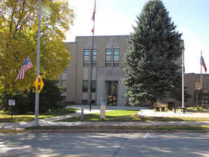
Allamakee County is the northeastern-most county located in the state of Iowa. Based on the 2010 census, the population was 14,330. Allamakee County was created on February 20, 1847. The county seat is Waukon. The county is named in honor of either Allan Makee, a trapper and trader, or is of Native American origin.
Etymology - Origin of Allamakee County Name
Allamakee is named for either Allan Makee, a trapper and trader, or is of Native American origin. (Unique county name)
Demographics:
County QuickFacts: CensusBureau Quick Facts
Allamakee County History
There is some debate over the origin
of the county name. Some say the county is named after Allan Makee, an Indian
trader and trapper, who was known by the Winnebago Indians. Other sources say
the name is purely of Indian origin. The county was established in 1847 and
originated in 1849.
The first county seat was located just northwest of Rossville, at a place called
"The Old Stake." This site was considered useless as there were other points of
greater importance already settled in Allamakee County.
In April 1851 the voters went to the polls to select a county seat. The towns
Vailsville, Smith's Mill and Columbus were the choices. None of them received a
majority of the votes. A second election was held the following May, with
Columbus receiving the most votes. Soon after Columbus was selected as the
county seat, a rivalry developed between Columbus and Lansing. Due to this a
commission was appointed to select the county seat. The site they selected was
Waukon. This choice went to an election. Even though Columbus fought the
decision, the results were overwhelmingly for Waukon.
A courthouse was built in Waukon in 1853. It was a small frame structure that
cost $325 to construct. It was used until 1857, when a similar building was
constructed next to it. These two buildings served the county until 1861, when
the county seat was moved again.
A heated contest between the towns of Waukon and Lansing developed. Both towns
agreed to build on suitable lots and both towns offered substantial "rewards"
for the county seat. Lansing offered $8,000 and Waukon offered $5,000 towards
the courthouse.
Between 1860-1861, following an election, a $13,000 courthouse was built at
Waukon. The city paid $5,000 as promised. Although Waukon had a courthouse, it
was not the county seat. That distinction went to "The Point." Located between
Lansing and Capoli, "The Point" became the site of a $5,000, stone structure
courthouse. The cost was paid by the citizens of Lansing.
In the summer of 1866 the citizens of Waukon attempted to regain the county
seat. A gang of 30 men from Waukon tried to steal the county records from the
courthouse at "The Point." This attempt failed, but the one in 1867 did not. A
10th county seat election was held. Waukon won out, after a 25-year long battle.
The present courthouse is of modern design. It was built between 1940 and 1941,
and it replaced the $13,000 courthouse built in 1861. The old courthouse was
taken over by the Allamakee County Historical Society; it now functions as a
museum.
Geography: Land and Water
As reported by the Census Bureau, the county has a total area of 659 square miles (1,710 km2), of which 639 square miles (1,660 km2) is
land and 20 square miles (52 km2) (3.0%) is water.
Allamakee county is located in northeast Iowa.
In the northern part of the county is the Upper Iowa River. In the southern part is the Yellow River. The eastern boundary is the Mississippi
River. It is a scenic and recreational area, particularly in Yellow River State Forest.
French Creek flows north of Waukon, outside the city limits. Paint Creek, named after Paint Rock Bluff, flows out of the south of Waukon.
Norfolk creek originates in the western borders of Waukon and is
overflow to the Yellow River. Clear Creek flows into Lansing. Village Creek
flows through rural terrain. All are tributary to the Mississippi River.
The landforms encountered in the county are very unlike those found in
most of Iowa, which is mostly absent Glacial Drift.
Neighboring Counties
Bordering counties are as follows:
- North: Houston County, Minn.
- Northeast: Vernon County, Wis.
- East: Crawford County, Wis.
- South: Clayton County
- Southwest: Fayette County
- West: Winneshiek County
Education


Click Image to Enlarge
