


Click Image to Enlarge
Iowa Counties
There are ninety-nine counties in Iowa. The first two counties, Des Moines County and Dubuque County, were created in 1834 when Iowa was still part of the Michigan Territory. In preparation for Michigan's statehood, part of Michigan Territory was formed into Wisconsin Territory in 1836]. Two years later, the western portion was split off to become Iowa Territory. The south-eastern part of Iowa Territory became Iowa, the 29th state in the union, on 28 December 1846, by which point 44 Counties had been created. Counties continued to be created by the state government until 1857, when the last county, Humboldt County, was created.Appanoose County, Iowa
Appanoose County Education, Geography, and History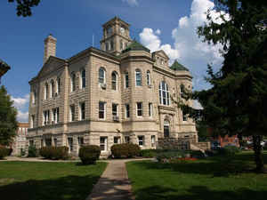
Appanoose County is a county located in the state of Iowa. Based on the 2010 census, the population was 12,884. Appanoose County was created on February 17, 1843. The county seat is Centerville. The county is named in honor of Appanoose, a chief of the Sac and Fox Native American tribes who headed the peace party during the Black Hawk War.
Etymology - Origin of Appanoose County Name
Appanoose is named for Appanoose, a chief of the Sac and Fox Native American tribes who headed the peace party during the Black Hawk War. (Unique county name)
Demographics:
County QuickFacts: CensusBureau Quick Facts
Appanoose County History
Appanoose County was established in
1843 and originated by the Iowa Territorial Legislature on January 13, 1846. It
is named for the chief of the Sac and the Fox Indian tribes who headed the peace
party during the Black Hawk War. Appanoose means "A Chief When a Child."
Appanoose County was one of the main coal mining areas in Iowa during the first
third of the 20th Century.
On November 1, 1844 the Legislative Assembly of Iowa ordered Andrew Leach and
William S. Whitaker to locate the county seat of Appanoose County. It was soon
located and named Chaldea. It was then platted by the county surveyor. The name
Chaldea was later changed to Senterville, in honor of Governor Senter, of
Tennessee. The spelling was changed and the county seat of Appanoose is
currently Centerville.
In the summer of 1847 it was decided that the county would erect a courthouse,
but nothing was done at this time. On September 10, that same year, the
dimensions and plans for the courthouse were decided upon and bids were sent
out. The contract was given to James Jackson for $160 and the finish work was
done by Jesse Wood for $119. The building was ready for occupation in April
1848. This courthouse was used until 1857.
The construction of a second courthouse began in 1860 and was completed in 1864.
During this time the county business was conducted in local churches. This
courthouse was destroyed by a fire on the Fourth of July. It seems that people
were lighting fireworks from the courthouse cupola and throwing them into the
air. One rocket evidently landed in the box with all the other fireworks and
exploded. The fire destroyed the cupola and most of the second floor. The county
continued to use the building but finally gave up in 1903.
The cornerstone for the third, and current courthouse was laid on May 21, 1903.
It cost $90,600 to build and was designed by the architects Smith and Gage. The
exterior walls are covered with Bedford stone veneer and the roof is all tile.
The clock tower, which rises from the middle of the building, sets the building
apart from all others. The courthouse is situated on a large town square and is
the pride of Centerville and Appanoose County.
Geography: Land and Water
As reported by the Census Bureau, the county has a total area of 516 square miles (1,340 km2), of which 497 square miles (1,290 km2) is land and 19 square miles (49 km2) (3.7%) is water.
Appanoose county is located in south Iowa. The Rathbun Reservoir, created by damming the Chariton River, is located in this county.
Neighboring Counties
Bordering counties are as follows:
- North: Monroe County
- Northeast: Wapello County
- East: Davis County
- Southeast: Schuyler County, Mo.
- Southwest: Putnam County, Mo.
- West: Wayne County
- Northwest: Lucas County
Education


Click Image to Enlarge
