


Click Image to Enlarge
Iowa Counties
There are ninety-nine counties in Iowa. The first two counties, Des Moines County and Dubuque County, were created in 1834 when Iowa was still part of the Michigan Territory. In preparation for Michigan's statehood, part of Michigan Territory was formed into Wisconsin Territory in 1836]. Two years later, the western portion was split off to become Iowa Territory. The south-eastern part of Iowa Territory became Iowa, the 29th state in the union, on 28 December 1846, by which point 44 Counties had been created. Counties continued to be created by the state government until 1857, when the last county, Humboldt County, was created.Calhoun County, Iowa
Calhoun County Education, Geography, and History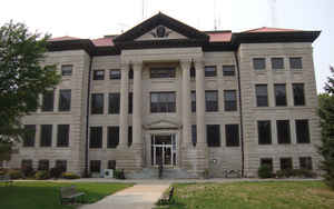
Calhoun County is a county located in the state of Iowa. Based on the 2010 census, the population was 9,670. Calhoun County was created on January 15, 1851. The county seat is Rockwell City. The county is named in honor of John Caldwell Calhoun, the seventh vice president of the United States from 1825–1832.
Etymology - Origin of Calhoun County Name
Calhoun county is named for John Caldwell Calhoun, the seventh vice president of the United States.
Demographics:
County QuickFacts: CensusBureau Quick Facts
Calhoun County History
In 1851, when the western half of
Iowa organized, the name of Fox was given to the county. The Sac and Fox Indians
had lived in the area, and, accordingly, the county west of Calhoun was named
Sac in honor of the Indians. A friend of former U. S. Vice President John C.
Calhoun did not like the name Fox, so the Iowa Legislature changed the name to
Calhoun in 1853.
Before Calhoun County was organized, residents paid taxes to Greene County. They
observed that very little revenue came back to make improvements in Calhoun
County, so they took the necessary steps to organize in 1855, with a population
of less than 100. Until a courthouse was built in Lake City in 1856, county
business was conducted in the homes of the officials.
When the Illinois Central Railroad was built in 1870, the counties' northern
towns of Manson and Pomeroy had grown and become rivals of Lake City for the
county seat. In 1876, this came to a head and it was voted to put the courthouse
as near the center of the county as possible. Rockwell City, platted on the only
high ground within a one-mile radius of the center of the county, was founded
and became the county seat.
The first courthouse in Rockwell City was completed for less than $2,000 and
also served as a schoolhouse.
In 1880, town founder Mr. Rockwell learned that F. M. Hubbell was bringing his
railroad as far as Jefferson. Rockwell went to Des Moines and promised Hubbell
half of the town lots if he would bring the railroad to Rockwell City. The first
train arrived August 7, 1882, and the population doubled that year.
Few people are aware that the early courthouse on the square wwas used for
activities other than "holding court." The Calhoun County courthouse was used as
an auditorium for public entertainment, political gatherings, and church
dinners.
When the courthouse burned down in 1884, a hotel and another building were
rented for $1 a day apiece to house county offices. The Board of Supervisors
decided to build the new courthouse further away from the railroad, because when
trains came through, all courthouse business at the old location was suspended
because of the noise. A fourth courthouse was built in 1913.
During the turn of the century, drainage came to Calhoun County. Through digging
of dredge ditches and laying of countless miles of clay drain tile, the county
was lifted out of water and has now become one of the best and most productive
agricultural counties in the state.
Compiled by Recorder Marty Minnick
Sources:
Calhoun County History 1854-1982, Calhoun County Historical Society, Copyright
1982.
-Doug Jensen, Fort Dodge Messenger article 9/27/87
-Brief History of Calhoun County, adapted and extended by Ruby Pridemore,
-Who's Who in Iowa, 1940 "Calhoun County Historical Society"
Geography: Land and Water
As reported by the Census Bureau, the county has a total area of 572 square miles (1,480 km2), of which 570 square miles (1,500 km2) is land and 2.1 square miles (5.4 km2) (0.4%) is water.
Calhoun county is located in west Iowa.
Neighboring Counties
Bordering counties are as follows:
- North: Pocahontas County
- East: Webster County
- Southeast: Greene County
- Southwest: Carroll County
- West: Sac County
- Northwest: Buena Vista County
Education


Click Image to Enlarge
