


Click Image to Enlarge
Iowa Counties
There are ninety-nine counties in Iowa. The first two counties, Des Moines County and Dubuque County, were created in 1834 when Iowa was still part of the Michigan Territory. In preparation for Michigan's statehood, part of Michigan Territory was formed into Wisconsin Territory in 1836]. Two years later, the western portion was split off to become Iowa Territory. The south-eastern part of Iowa Territory became Iowa, the 29th state in the union, on 28 December 1846, by which point 44 Counties had been created. Counties continued to be created by the state government until 1857, when the last county, Humboldt County, was created.Des Moines County, Iowa
Des Moines County Education, Geography, and History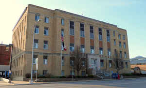
Des Moines County is a county located in the state of Iowa. Based on the 2010 census, the
population was 40,325. Des Moines County was
created on October 1, 1834. The county seat
is Burlington. The county is named for the Des Moines
River, river that once ran through the county.
Des Moines County is part of the Burlington, IA-IL Micropolitan Statistical Area.
Etymology - Origin of Des Moines County Name
Des Moines county is named for the Des Moines River.
Demographics:
County QuickFacts: CensusBureau Quick Facts
Des Moines County History
Until 1833, Indians held the land
that is now Des Moines County. It was named for the Des Moines River which runs
through southeastern Iowa. For some years, a branch of the American Fur Company
had a trading post on the present site of the city of Burlington. Immediately
upon settling on the land, whites applied for license to maintain a public ferry
across the Mississippi River.
The US flag was first officially unfurled over Iowa soil at Burlington on
August 23, 1805 by Lieutenant Zebulon M. Pike during an expedition to explore
the Mississippi.
Des Moines County was established and originated in 1834. It and Dubuque County
were the only counties in existence at this time. Together they contained all of
present day Iowa in their borders. In 1836 the Wisconsin Legislature split Des
Moines County into Lee, Van Buren, Des Moines, Henry, Louisa, Muscatine and Cook
counties. The present boundaries of Des Moines County were established in 1839.
The county is named for the river that runs through it.
It is one of Iowa's two original counties along with Dubuque County;
both were organized by the Michigan Territorial legislature in 1834.
Des Moines County was entitled to 10 members of the House of Representatives at
Belmont, Wisconsin in October 1836. One of the bills passed at this session
selected Burlington as the temporary capital of the Territory.
In 1838 the city of Burlington was chosen to become the county seat and the
capital of the Territory of Iowa. There was little dispute because Burlington
was the only area of significance, and it had been serving as the temporary
county seat since 1834.
In May of 1839 the first paper, the Burlington Patriot, was published in the
county. Its name was changed from Patriot to Hawkeye and back to Patriot and,
finally, back to Hawkeye. It is still in circulation and is Iowa's oldest
newspaper.
The first court was held in a log cabin on April 13, 1835. It was later held in
the "Old Zion" Methodist church, houses and stores. The first county courthouse
was built in 1850. Marion Hall was constructed and then leased to the city for
use as a courthouse. This two-story brick building was named after the wife of
H. W. Star, one of the builders. The courthouse was later moved to Mozart Hall.
This building, along with some of the county records, was destroyed by a fire in
1873.
At one time (in 1905) the Board of Supervisors consisted of four members, but it
was changed to three members in 1906 and remains so today.
The present courthouse of Des Moines County was constructed in 1939. Total cost
of the project, including land and furnishings, was $280,000.
A new Correctional Facility opened for business on March 25, 1995. It is a 62
bed jail, built for $3.5 million.
Sources:
Glass, Remely J. Iowa and Counties of Iowa., Klipto Loose Leaf Company, Mason
City, Iowa: 1940.
Anita Kohl, Des Moines County Recorder
Carol Copeland, Des Moines County Auditor, 2002
Geography: Land and Water
As reported by the Census Bureau, the county has a total area of 430 square miles (1,100 km2), of which 416 square miles (1,080 km2) is land and 14 square miles (36 km2) (3.2%) is water.
Des Moines county is located in southeast Iowa. The Mississippi River forms the east border; Skunk River, the south border; and the county
is drained by Flint Creek.
Neighboring Counties
Bordering counties are as follows:
- North: Louisa County
- Northeast: Mercer County, Ill.
- Southeast: Henderson County, Ill.
- Southwest: Lee County
- West: Henry County
Education


Click Image to Enlarge
