


Click Image to Enlarge
Iowa Counties
There are ninety-nine counties in Iowa. The first two counties, Des Moines County and Dubuque County, were created in 1834 when Iowa was still part of the Michigan Territory. In preparation for Michigan's statehood, part of Michigan Territory was formed into Wisconsin Territory in 1836]. Two years later, the western portion was split off to become Iowa Territory. The south-eastern part of Iowa Territory became Iowa, the 29th state in the union, on 28 December 1846, by which point 44 Counties had been created. Counties continued to be created by the state government until 1857, when the last county, Humboldt County, was created.Emmet County, Iowa
Emmet County Education, Geography, and History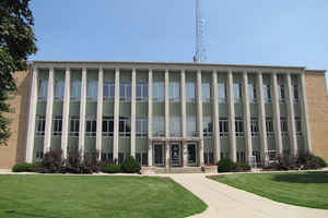
Emmet County is a county located in the state of Iowa. Based on the 2010 census, the population was 10,302. Emmet County was created on January 15, 1851. The county seat is Estherville. The county is named in honor of Robert Emmet (1778–1803), Irish revolutionary and American republican sympathizer.
Etymology - Origin of Emmet County Name
Emmet county is named for Robert Emmet, an Irish patriot.
Demographics:
County QuickFacts: CensusBureau Quick Facts
Emmet County History
Emmet County was one of 50 new
counties set up by Governor Stephen Hempstead on January 15, 1851. It is named
after the Irish orator, nationalist and patriot Robert Emmet. He was executed in
1803 for his activity in the Irish rebellion.
The boundaries of the county have stayed the same ever since its establishment
in 1851. Since whites were scattered so thinly, it was not until 1856 that the
first settlers came to Emmet County. At this time Emmet was attached to Webster
County for governmental purposes.
In the winter of 1858-59 the residents of Emmet County decided it was "below
their dignity to remain any longer under the jurisdiction of Webster County." A
petition was circulated and they were granted separate organization on February
7, 1859.
Two commissioners were entrusted with the selection of the county seat. They
surveyed the county and decided on the site of Estherville. Plans were started
and a contract was negotiated for the erection of a school house and courthouse.
They were to be financed through the sale of the swamp lands that lay within the
county. The survey, which was done by the county, was not accepted by the
surveyor-general, and the county failed to obtain title to the land. The school
house was already completed, but the construction of the courthouse was
immediately stopped when it was discovered that the county had no land to
transfer to the contractors for payment. The schoolhouse was moved and used as a
courthouse until 1876, when it was destroyed by a fire.
Since its conception the county seat at Estherville has not faired well with the
residents of the eastern part of the county, who felt it should be more
centrally located. They were hesitant due to the cost of building a new
courthouse at a new site. However, with the burning of the courthouse in 1876,
the opposition to Estherville grew. Petitions were circulated calling for an
election on the removal of the county seat. At the same time a remonstrance was
filed and submitted to the board.
An election was held on October 14, 1879, with Swan Lake being the alternate
site. Swan Lake won the election, and the Board was instructed to move to the
new county seat. They refused, and even after a district court action, the
county seat was not formally established at Swan Lake until January 9, 1880.
Proceedings were instituted in the courts to test the legality of the first
election, and, in 1882, a petition was filed calling for another election. The
Board granted it, and on November 7, 1882, a second election was held. This time
Estherville won the right to the county seat. In spite of the claim that the
workers building the B.C.R.& N. had voted illegally, the election was declared
legal, and Estherville again became the county seat on January 15, 1883.
Following this a courthouse was built at Estherville at a cost of $12,000. It
was located on the city square, which was given to the county by the city.
It was around 1916 when the need for a new courthouse was discovered, but it was
not until 1954 that a grand jury voted to recommend that the county build a new
courthouse. Plans were drawn up, and bids were let. The Lundquist Construction
Company of LeMars was awarded the contract and the cornerstone was laid on June
1, 1957. It was ready for occupation on July 28, 1958, and the wrecking of the
old courthouse began.
Source: Dorothy Mergen, Emmet County Recorder
Geography: Land and Water
As reported by the Census Bureau, the county has a total area of 403 square miles (1,040 km2), of which 396 square miles (1,030 km2) is land and 6.6 square miles (17 km2) (1.4=6%) is water.
Emmet county is located in northwest Iowa. The county is the second-smallest county by land area in Iowa, and the fourth-smallest by total
area.
Neighboring Counties
Bordering counties are as follows:
- Northeast: Martin County, Minn.
- Southeast: Kossuth County
- South: Palo Alto County
- Southwest: Clay County
- West: Dickinson County
- Northwest: Jackson County, Minn.
Education


Click Image to Enlarge
