


Click Image to Enlarge
Iowa Counties
There are ninety-nine counties in Iowa. The first two counties, Des Moines County and Dubuque County, were created in 1834 when Iowa was still part of the Michigan Territory. In preparation for Michigan's statehood, part of Michigan Territory was formed into Wisconsin Territory in 1836]. Two years later, the western portion was split off to become Iowa Territory. The south-eastern part of Iowa Territory became Iowa, the 29th state in the union, on 28 December 1846, by which point 44 Counties had been created. Counties continued to be created by the state government until 1857, when the last county, Humboldt County, was created.Greene County, Iowa
Greene County Education, Geography, and History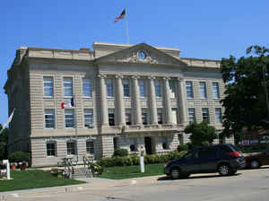
Greene County is a county located in the state of Iowa. Based on the 2010 census, the population was 9,336. The county is named in honor of Nathaniel Greene (1742–1786), a general in the American Revolutionary War. The county seat is Jefferson. The county is named in honor of General Nathanael Greene.
Etymology - Origin of Greene County Name
Greene county is named for Nathanael Greene, a general in the American Revolutionary War.
Demographics:
County QuickFacts: CensusBureau Quick Facts
Greene County History
Greene County was established in 1851
and organized in 1854, with a population of 150 and Jefferson (for Thomas
Jefferson) as the county seat. The county was named after General Nathanial
Greene, a hero of the Revolutionary War.
The first courthouse was the log cabin of Judge William Phillips about four
miles southeast of Jefferson. Jefferson was chosen as the county seat in 1854. A
true courthouse was built in 1856. A new one was erected in 1870. The courthouse
bell was used for calling court, curfew, and as a fire alarm. The present
courthouse was built in 1917 for $179,752.66.
In the spring of 1857, rumors of a gold strike on a small stream west of
Jefferson caused great excitement without much result.
Roads played an important part in Greene County history. In 1904, the first
concrete span bridge in Greene County was built over Hardin Creek east of
Jefferson on the old Lincoln Highway. In 1909, led by a Jefferson banker and
good roads advocate, a small group of men spent several days filling holes on 35
miles of county road. This work was done to prepare for an auto touring caravan.
The tourists stopped for 10 minutes or so and "sang the praises of our Greene
County roads which they pronounced the best-kept country roads they had struck
in their journey!"
For a few weeks early in 1926, all Jefferson banks had failed and were closed,
making Jefferson the largest city in the U. S. without a bank.
Greene County was apparently a popular stop for presidential candidates.
Governor Harold Stassen of Minnesota launched his 1948 presidential campaign by
making an address from the south balcony of the Greene County Courthouse. In
1952, Dwight and Mamie Eisenhower made a whistle stop an Jefferson depot on a
presidential campaign train tour.
The 162-foot carillon of Jefferson recently celebrated its 25th anniversary. The
Mahanay Memorial Carillon Tower, named for its founders Floyd and Dora Mahanay,
has been the trademark of Jefferson ever since its construction 25 years ago.
The dedication of the tower will also kick off the "Bell Tower Community
Foundation." They hope to raise $300,000 to renovate and add 34 new bells to the
carillon.
Geography: Land and Water
As reported by the Census Bureau, the county has a total area of 571 square miles (1,480 km2), of which 570 square miles (1,500 km2) is land and 1.6 square miles (4.1 km2) (0.3%) is water.
Greene county is located close to the center of Iowa.
Neighboring Counties
Bordering counties are as follows:
- Northeast: Webster County
- East: Boone County
- Southeast: Dallas County
- South: Guthrie County
- West: Carroll County
- Northwest: Calhoun County
Education


Click Image to Enlarge
