


Click Image to Enlarge
Iowa Counties
There are ninety-nine counties in Iowa. The first two counties, Des Moines County and Dubuque County, were created in 1834 when Iowa was still part of the Michigan Territory. In preparation for Michigan's statehood, part of Michigan Territory was formed into Wisconsin Territory in 1836]. Two years later, the western portion was split off to become Iowa Territory. The south-eastern part of Iowa Territory became Iowa, the 29th state in the union, on 28 December 1846, by which point 44 Counties had been created. Counties continued to be created by the state government until 1857, when the last county, Humboldt County, was created.Henry County, Iowa
Henry County Education, Geography, and History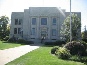
Henry County is a county located in the state of Iowa. Based on the 2010 census, the population was 20,145. Henry County was created on December 7, 1836. The county seat is Mount Pleasant. Henry county is named for General Henry Dodge, governor of Wisconsin Territory.
Etymology - Origin of Henry County Name
Henry county is named for Henry Dodge, a governor of the Wisconsin Territory (which included present-day Iowa) and later United States senator from Wisconsin.
Demographics:
County QuickFacts: CensusBureau Quick Facts
Henry County History
The boundaries of Henry County were
defined by the Territorial Legislature of Wisconsin in 1836, but it was not
legally established until 1837 by the Iowa Territorial Legislature. Prior to
establishment of Jefferson County on the west in 1839, all of that part of the
Black Hawk Purchase situated in the present county of Jefferson, was attached to
Henry County for judicial purposes.
The county was named for Henry Dodge, who was a general in the Black Hawk War
and was governor of the Wisconsin Territory.
The first courthouse in the state of Iowa was built in Mount Pleasant in 1839. A
second courthouse, used from 1871 - 1914 was the remodeled "Hill Hall," on the
same block as the county jail. When it was put up for sale in 1914 it only
brought $247.50. The present building was completed in 1914.
The earliest roads followed the tops of ridges and Indian paths. Later, they cut
straight against the plain. Many of these roads still retain their original
locations as originally surveyed and laid out.
Henry County was the only county in Iowa to have two military roads, present
US route 218 was one of them.
Sources:
Iowa Press Assn. "Who's Who in Iowa" copyright 1940
Henry County Bicentennial Commission
Geography: Land and Water
As reported by the Census Bureau, the county has a total area of 437 square miles (1,130 km2), of which 434 square miles (1,120 km2) is land and 2.2 square miles (5.7 km2) (0.5%) is water.
Henry county is located in southeast Iowa. Lake Geode is located in
this county.
Neighboring Counties
Bordering counties are as follows:
- Northeast: Louisa County
- East: Des Moines County
- South: Lee County
- Southwest: Van Buren County
- West: Jefferson County
- Northwest: Washington County
Education


Click Image to Enlarge
