


Click Image to Enlarge
Iowa Counties
There are ninety-nine counties in Iowa. The first two counties, Des Moines County and Dubuque County, were created in 1834 when Iowa was still part of the Michigan Territory. In preparation for Michigan's statehood, part of Michigan Territory was formed into Wisconsin Territory in 1836]. Two years later, the western portion was split off to become Iowa Territory. The south-eastern part of Iowa Territory became Iowa, the 29th state in the union, on 28 December 1846, by which point 44 Counties had been created. Counties continued to be created by the state government until 1857, when the last county, Humboldt County, was created.Marion County, Iowa
Marion County Education, Geography, and History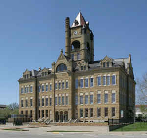
Marion County is a county located in the state of Iowa. Based on the 2010 census, the population was 33,309. Marion County was created on June 10, 1845. The county seat is Knoxville. The county is named for Francis Marion, The Swamp Fox, a brigadier general from South Carolina in the American Revolutionary War, or a leading pioneer whose name is not recorded.
Etymology - Origin of Marion County Name
Marion county is named for either Francis Marion, the "Swamp Fox" general of the American Revolutionary War, or a leading pioneer whose name is not recorded.
Demographics:
County QuickFacts: CensusBureau Quick Facts
Marion County History
Some say Marion County was named for
a pioneer who was a favorite character among early settlers. It could also have
been named for Francis Marion, American commander in the Revolutionary War. The
popularity of the name is attested by the 17 counties in the US of that name.
Marion County, Iowa, was formally organized in 1845, and Knoxville was chosen as
the county seat.
The first courthouse was a log cabin. In 1856, the people became dissatisfied
and decided the county was rich enough to have a new courthouse. In 1895 the
Board called for a special election to replace the 1856 brick courthouse.
Another new courthouse was proposed in the 1960s but was voted down. Instead,
updating the old courthouse began in 1972. Today, the beautiful old courthouse
has a good sound foundation and an interior full of history.
The Iowa flag was designed by Marion County native Dixie Cornell Gebhart. The
flag was carried during World War I by local troops and the Iowa Legislature
approved it as the state flag on March 29, 1921.
In 1996 an open house with period costumes and entertainment was held to honor
the 100th birthday of our Courthouse. This celebration coincided with the
sesquicentennial of the State of Iowa.
Source: Marion County Recorder
Geography: Land and Water
As reported by the Census Bureau, the county has a total area of 571 square miles (1,480 km2), of which 555 square miles (1,440 km2) is land and 16 square miles (41 km2) (2.8%) is water.
Marion county is located close to the center of Iowa.
Neighboring Counties
Bordering counties are as follows:
- North: Jasper County
- East: Mahaska County
- Southeast: Monroe County
- Southwest: Lucas County
- West: Warren County
- Northwest: Polk County
Education


Click Image to Enlarge
