


Click Image to Enlarge
Iowa Counties
There are ninety-nine counties in Iowa. The first two counties, Des Moines County and Dubuque County, were created in 1834 when Iowa was still part of the Michigan Territory. In preparation for Michigan's statehood, part of Michigan Territory was formed into Wisconsin Territory in 1836]. Two years later, the western portion was split off to become Iowa Territory. The south-eastern part of Iowa Territory became Iowa, the 29th state in the union, on 28 December 1846, by which point 44 Counties had been created. Counties continued to be created by the state government until 1857, when the last county, Humboldt County, was created.Mills County, Iowa
Mills County Education, Geography, and History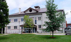
Mills County is a county located in the
state of Iowa. Based on the 2010 census, the population was
15,059. The county was created in 1851. The county
seat is Glenwood. Mills county is named
for Major Frederick Mills of Burlington, Iowa who was killed at the Battle
of Churubusco during the Mexican-American War.
Mills County is included in the Omaha-Council Bluffs, NE-IA Metropolitan Statistical
Area.
Etymology - Origin of Mills County Name
Mills county is named for Frederick Mills, a major from Iowa killed in the Mexican-American War.
Demographics:
County QuickFacts: CensusBureau Quick Facts
Mills County History
Mills County, organized and established in 1851 and was named for a young
officer from Burlington, Iowa. Frederick Mills, a Yale graduate and lawyer,
was enlisted and commissioned as an officer during the Mexican War from 1846-1848.
He was killed August 20, 1847, leading a charge after General Santa Ana in
the Battle of Cherubusco. In 1851, Mills County was named in memory of this
hero.
The first settlement was called Rushville by the Mormons who arrived in 1846.
Coonsville, named after Dr. Liberius Coons, a Mormon, first doctor and founder
of the community, was changed to present-day Glenwood in 1853.
The first courthouse was a small 12' x 20' frame building which was replaced
in 1857 by a two-story Georgian Colonial style building. An addition was made
sometime after 1900 followed by the addition of a clock tower in 1910. This
first courthouse served as home to the first newspaper in Mills County as
well as a temporary barracks for Civil War troops in 1861. In 1898, an Iowa
company was organized in the courthouse to serve in the war with Spain. This
courthouse continued to serve its community well for the next 100 years. In
1959, it was replaced with the current, more modern building. The building
was dedicated on August 29, 1959, amidst much fanfare.
Geographically, Mills County is located very near to the extreme southwest
corner of Iowa. It is bordered on the North by Pottawattamie County, on the
East by Montgomery County, on the South by Fremont County, and on the West
by the Missouri River. It is primarily an agricultural area. Many residents,
however, work in industries in nearby Council Bluffs, Iowa and Omaha, Nebraska.
Mills County boasts a variety of historical sites including a museum located
in Glenwood which showcases many tools, implements, and household items of
early life in the county as well as many Indian artifacts. The community of
Tabor, which lies partly in Mills County, is the location of a once important
station on the Underground Railroad, as well as the home of Rev. John Todd
who harbored the abolitionist, John Brown. The Todd house is preserved and
now serves as a museum. Pacific Junction in the Western part of the county
is the Junction for the Burlington Railroad lines from Denver to Chicago and
Kansas City to Council Bluffs.
In addition, Glenwood is the site of the Glenwood State Hospital- School,
the state operated home and school for the mentally handicapped. Started as
a Soldier's Orphan's Home in 1866, it was closed in 1876 and the General Assembly
converted the orphanage into the Asylum for Feeble Minded Children. Later
renamed the Glenwood State Hospital-School, this became an important part
of the lives of the inhabitants.
The 2000 census shows Mills county with an area of 439.67 square miles (3.13
of which is water) and a population of 14,547.
Sources: Beth Sylvester, Mills County Auditor, 2002
Geography: Land and Water
As reported by the Census Bureau, the county has a total area of 441 square miles (1,140 km2), of which 437 square miles (1,130 km2) is land and 3.2 square miles (8.3 km2) (0.7%) is water.
Mills county is located in southwest Iowa. This county is located in the middle of the Loess Hills and rivers of Southwest Iowa. There are 9 parks, lakes, wildlife areas and forests that includes 1,737 acres across the county.
Neighboring Counties
Bordering counties are as follows:
- North: Pottawattamie County
- East: Montgomery County
- Southeast: Page County
- South: Fremont County
- Southwest: Cass County, Neb.
- West: Sarpy County, Neb.
Education


Click Image to Enlarge
