


Click Image to Enlarge
Iowa Counties
There are ninety-nine counties in Iowa. The first two counties, Des Moines County and Dubuque County, were created in 1834 when Iowa was still part of the Michigan Territory. In preparation for Michigan's statehood, part of Michigan Territory was formed into Wisconsin Territory in 1836]. Two years later, the western portion was split off to become Iowa Territory. The south-eastern part of Iowa Territory became Iowa, the 29th state in the union, on 28 December 1846, by which point 44 Counties had been created. Counties continued to be created by the state government until 1857, when the last county, Humboldt County, was created.Monona County, Iowa
Monona County Education, Geography, and History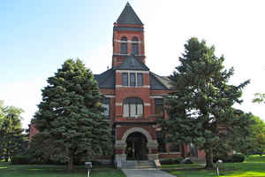
Monona County is a county located in the state of Iowa. Based on the 2010 census, the population was 9,243. Monona County was created on January 15, 1851. The county seat is Onawa. The county is named for a word of uncertain Native American meaning. The word may mean “Peaceful Valley” or “Beautiful Valley.”
Etymology - Origin of Monona County Name
The name of Monona County (701 square miles) is believed to be of Indian origin, but its exact meaning is not known. The word may mean "Peaceful Valley" or "Beautiful Valley." Monona was also said to be the name of an Indian maiden who committed suicide by jumping from a high cliff into the Mississippi River in the belief that her own tribesmen had killed her white lover. Some authorities suggest that the county was named for Monona, a town in Clayton County, at the suggestion of Eliphalet Price, representative from Clayton County in the Third General Assembly.
Demographics:
County QuickFacts: CensusBureau Quick Facts
Monona County History
Monona is named for a word of uncertain Native American meaning.
The county was established in 1851. The county's business was first transacted
at the Mormon village called Preparation, in Spring Valley Township, where some
of the first settlements were made. When Ashton (originally called Bloomfield)
was named the county seat in the fall of 1854, a log house served as the first
courthouse. Ashton remained the county seat for only four years.
Following an election, county records were removed to Onawa, where a frame
courthouse was built during the summer of 1858, at a cost of about $7,000.
Attempts were made from 1861 until 1889 to remove the county seat to Belvidere,
Arcola, and East Mapleton, but each contest in its turn ended in favor of Onawa.
A courthouse was built in 1891-1892 by S.E. Maxon and Company of Omaha. This
brick Romanesque building, with gabled roof surmounted by a tower, is located on
the same site as the previous courthouse. A one-story addition was built on the
West side of the courthouse in 1967, and another on the East side in 1973.
The old jail was condemned, and Monona County joined with the City of Onawa to
construct a law enforcement center, including jail facilities, which was
completed in September 1974.
An annex to the courthouse was built in 1980 and dedicated in 1981. This annex
was built for court facilities. The original judge's bench, furniture, and
fixtures were restored and are being used in the new courtroom.
An annex to the courthouse was built in 1980 and dedicated in 1981. This annex
was built for court facilities. The original judge's bench, furniture, and
fixtures were restored and are being used in the new courtroom. Also an entire
third floor of the building was built and now houses the Department of Human
Services. And finally, the basement annex was remodeled to house the county
health nurses and the magistrate court.
Sources:
County Recorder Harriet Gray for the county history book commissioned by the
Monona County Historical society and published in 1982.
Benita J. Davis, Monona County Auditor, 2002
Geography: Land and Water
As reported by the Census Bureau, the county has a total area of 699 square miles (1,810 km2), of which 694 square miles (1,800 km2) is land and 4.9 square miles (13 km2) (0.7%) is water.
Monona county is located in west Iowa along the Missouri River and is
the center of the Loess Hills. There are 17 individual parks, natural
areas, preserves and water recreation accesses surrounding some 900
acres across the county.
Neighboring Counties
Bordering counties are as follows:
- North: Woodbury County
- Northeast: Ida County
- East: Crawford County
- Southeast: Harrison County
- Southwest: Burt County, Neb.
- West: Thurston County, Neb.
Education


Click Image to Enlarge
