


Click Image to Enlarge
Iowa Counties
There are ninety-nine counties in Iowa. The first two counties, Des Moines County and Dubuque County, were created in 1834 when Iowa was still part of the Michigan Territory. In preparation for Michigan's statehood, part of Michigan Territory was formed into Wisconsin Territory in 1836]. Two years later, the western portion was split off to become Iowa Territory. The south-eastern part of Iowa Territory became Iowa, the 29th state in the union, on 28 December 1846, by which point 44 Counties had been created. Counties continued to be created by the state government until 1857, when the last county, Humboldt County, was created.Monroe County, Iowa
Monroe County Education, Geography, and History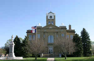
Monroe County is a county located in the state of Iowa. Based on the 2010 census, the population was 7,970. Monroe County was created on February 17, 1843. The county seat is Albia. The county is named in honor of James Monroe (1758–1831), the fifth president of the United States.
Etymology - Origin of Monroe County Name
Monroe county is named for James Monroe, the fifth president of the United States.
Demographics:
County QuickFacts: CensusBureau Quick Facts
Monroe County History
Monroe County, originally called
Kishkekosh County after a Fox Indian chief, is named after the author of the
Monroe Doctrine and fifth president of the United States James Monroe.
The county was established in 1843. When the county was being settled, there was
considerable controversy over the location of the county seat. The battle was
between the towns of Princeton (now Albia) and Clark's Point (Clarksville). On
August 5, 1845 a committee appointed to choose the county seat selected
Princeton as the county seat. In 1846 the Iowa Legislature changed the name of
Princeton to Albia, because there was already a Princeton in Iowa.
The first courthouse of Monroe County was a small log cabin, which was rented
out for $1 a month when court was not in session. This courthouse was 20-foot x
20-foot and one and one-half stories high. The contractor was paid $75 when it
was completed in 1846.
This courthouse was used until 1858 when it was replaced by the second Monroe
County courthouse. This building was built of brick at a cost of $10,900 and
located in the center of the town park.
The present courthouse replaced the second one on October 26, 1903. The original
price tag of this building was to be $75,000 but the actual price ended up being
$93,000. The Renaissance style building is built from stone and brick. The
architect was O. O. Smith and the contractor was James Rowson & Sons.
Geography: Land and Water
As reported by the Census Bureau, the county has a total area of 434 square miles (1,120 km2), of which 434 square miles (1,120 km2) is land and 0.6 square miles (1.6 km2) (0.1%) is water.
Monroe county is located in southeast Iowa. The Lake Miami Area, and
Gladson Carmack Park, about 900 acres within the county.
Neighboring Counties
Bordering counties are as follows:
- Northeast: Mahaska County
- East: Wapello County
- Southeast: Davis County
- South: Appanoose County
- Southwest: Wayne County
- West: Lucas County
- Northwest: Marion County
Education


Click Image to Enlarge
