


Click Image to Enlarge
Iowa Counties
There are ninety-nine counties in Iowa. The first two counties, Des Moines County and Dubuque County, were created in 1834 when Iowa was still part of the Michigan Territory. In preparation for Michigan's statehood, part of Michigan Territory was formed into Wisconsin Territory in 1836]. Two years later, the western portion was split off to become Iowa Territory. The south-eastern part of Iowa Territory became Iowa, the 29th state in the union, on 28 December 1846, by which point 44 Counties had been created. Counties continued to be created by the state government until 1857, when the last county, Humboldt County, was created.Palo Alto County, Iowa
Palo Alto County Education, Geography, and History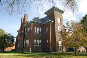
Palo Alto County is a county located in the state of Iowa. Based on the 2010 census, the population was 10,147. The county was created in 1851. The county seat is Emmetsburg. Palo Alto is named for the first battlefield victory in the Mexican-American War.
Etymology - Origin of Palo Alto County Name
Palo Alto is named for the Battle of Palo Alto in the Mexican-American War.
Demographics:
County QuickFacts: CensusBureau Quick Facts
Palo Alto County History
Palo Alto County is named for the
first battlefield victory in the Mexican War, which was fought on May 8, 1846.
The county was established in 1851. The first settlement in the county was at
West Bend. In 1857 some men of Palo Alto County joined the relief expedition
from Fort Dodge to the scene of the Spirit Lake Massacre. (See Dickinson
County.) West Bend provided food and shelter for both the military group and
survivors of the massacre.
As soon as the county was organized on December 20, 1858, three locating
commissioners met to locate the site of the county seat. The site they selected
was a small village called Paoli, although county business was taken care of at
a placed called Soda Bar.
County swamp land was sold to pay for the courthouse and a school in Paoli. The
two-story brick structure collapsed during its construction. County officials
decided to rebuild the building, this time only half the size. The courthouse
was finally completed in 1859.
In 1874, representatives of a railroad company met with businessmen of Old Town,
the most established community at the time, proposing a mass move. Having
platted the new town, the railroad was willing to give businessmen choice lots
if they would move. On September 2, the first business moved. By December, the
town of Emmetsburg had come into existence, to become the county seat in 1875.
In 1880 a brick courthouse was built in Emmetsburg, which is named after the
Irish patriot Robert Emmet. This 1880s building has undergone extensive repairs
over the years. Originally faced with yellow brick, it was refaced with red
brick during World War I. A tall tower was removed in the 1920s, and the jail
was removed from the basement and relocated. It was extensively remodeled in
1970, and a two-story and basement addition was completed in 1976-1977.
Out front, on the courthouse lawn, stands a statue of Robert Emmet and a rock
appropriately named the "Blarney Stone."
Geography: Land and Water
As reported by the Census Bureau, the county has a total area of 569 square miles (1,470 km2), of which 564 square miles (1,460 km2) is land and 5.6 square miles (15 km2) (1.0%) is water.
Palo Alto county is located in northwest Iowa. The county contains a
variety of lakes including Five Island Lake, Lost Island Lake, Rush
Lake, and Silver Lake.
Neighboring Counties
Bordering counties are as follows:
- North: Emmet County
- Northeast: Kossuth County
- Southeast: Humboldt County
- South: Pocahontas County
- Southwest: Buena Vista County
- West: Clay County
- Northwest: Dickinson County
Education


Click Image to Enlarge
