


Click Image to Enlarge
Iowa Counties
There are ninety-nine counties in Iowa. The first two counties, Des Moines County and Dubuque County, were created in 1834 when Iowa was still part of the Michigan Territory. In preparation for Michigan's statehood, part of Michigan Territory was formed into Wisconsin Territory in 1836]. Two years later, the western portion was split off to become Iowa Territory. The south-eastern part of Iowa Territory became Iowa, the 29th state in the union, on 28 December 1846, by which point 44 Counties had been created. Counties continued to be created by the state government until 1857, when the last county, Humboldt County, was created.Plymouth County, Iowa
Plymouth County Education, Geography, and History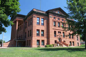
Plymouth County is a county located in the state of Iowa. Based on the 2010 census, the
population was 24,986. Plymouth County was
created on January 15, 1851. The county
seat is Le
Mars. Plymouth County is named after Plymouth, Massachusetts.
Plymouth County is part of the Sioux City, IA-NE-SD Metropolitan Statistical Area.
Etymology - Origin of Plymouth County Name
Plymouth is named for Plymouth, Massachusetts, the first settlement of the Pilgrims in 1620.
Demographics:
County QuickFacts: CensusBureau Quick Facts
Plymouth County History
Plymouth County, the fourth largest
county, was established on January 15, 1851 and formally organized on October
12, 1858. It is named after the landing place of Pilgrims on the Mayflower. The
county was attached to Woodbury County for judicial and other reasons prior to
1858.
The site of the first courthouse was in Melbourne. It was built in October of
1859 at a cost of $2,000. In 1861 the building was insured, desks were bought
and an outhouse and steps were added. The courthouse in Melbourne had many uses.
For example, it was used by the federal government as a winter quarters for
soldiers and as a grocery.
In 1872, by a close vote, the county seat was moved to LeMars. The town of
LeMars had been platted in 1869 and was named by using an interesting method. A
party of bankers, realtors, a state legislator, and state register of deeds took
an excursion to the LeMars area. The ladies along for the journey decided to use
their first names initials to name the town. In order to form a six letter word
from nine initials a combination of marital status and numbers was used. The
letters "L" and "M" each represented two married women. That is why both are
capitalized. The "e" stands for one married and one unmarried women and the "a,
r, s" each stand for one married women. The order of the "L" and "M" were chosen
by drawing straws. If it had gone the other way, LeMars could be MeLars today.
In 1874 residents voted to build a new courthouse in LeMars. Three thousand
dollars was appropriated from the swamp land fund, and the land was donated by
the Sioux City and Iowa Falls Town Lot and Land Company.
In 1900, at a general election on November 6, a proposal was passed to build a
new courthouse. It was to cost no more than $70,000. This building was
constructed in 1901-1902 by Emil Miller and was designed by Kinney and Detweiler
of Austin, Minnesota. The fireproof building was built of Portage-entry red
sandstone and was of the Renaissance style. It contained a tall portico,
Corinthian columns, and a central tower capped by a large dome. In 1913, the
large tower was removed due to the strain it caused.
Both the courthouse and county seat gained national attention in the spring of
1933, when Judge C. C. Bradley was kidnapped by an angry mob of farmers and was
threatened with hanging unless he stopped signing farm foreclosure notices. The
judge refused to comply, and although he was not hanged, he was taken out into
the country, smeared with oil and dirt and left to find his own way home.
In 1997, a three-story addition was added to the south side of the original
courthouse, adding an additional 8,175 sq. ft. It was constructed using
materials to blend with the original structure at a cost of approximately
$850,000. Presently a new Law Enforcement Center/Jail complex is being
constructed. The cost is approximately $5.4 million and plans are to open Spring
2003.
Source: Kae Meyer, Plymouth County Auditor, 2002
Geography: Land and Water
As reported by the Census Bureau, the county has a total area of 864 square miles (2,240 km2), of which 863 square miles (2,240 km2) is land and 0.8 square miles (2.1 km2) (0.1%) is water.
Plymouth county is located in west Iowa. This county is the fourth-largest county by area in Iowa.
Neighboring Counties
Bordering counties are as follows:
- North: Sioux County
- Northeast: O'Brien County
- East: Cherokee County
- Southeast: Woodbury County
- Northwest: Union County, S.Dak.
Education


Click Image to Enlarge
