


Click Image to Enlarge
Iowa Counties
There are ninety-nine counties in Iowa. The first two counties, Des Moines County and Dubuque County, were created in 1834 when Iowa was still part of the Michigan Territory. In preparation for Michigan's statehood, part of Michigan Territory was formed into Wisconsin Territory in 1836]. Two years later, the western portion was split off to become Iowa Territory. The south-eastern part of Iowa Territory became Iowa, the 29th state in the union, on 28 December 1846, by which point 44 Counties had been created. Counties continued to be created by the state government until 1857, when the last county, Humboldt County, was created.Pottawattamie County, Iowa
Pottawattamie County Education, Geography, and History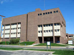
Pottawattamie County is a county located in the state of Iowa. Based on the 2010 census, the
population was 93,158. Pottawattamie County was
created on September 21, 1848. The county
seat is Council Bluffs. The county is named
for the Potawatomi Native American tribe.
Pottawattamie County is included in the Omaha-Council Bluffs, NE-IA Metropolitan Statistical Area.
Etymology - Origin of Pottawattamie County Name
Pottawattamie county is named for the Potawatomi (Pottawattamie) Native American people.
Demographics:
County QuickFacts: CensusBureau Quick Facts
Pottawattamie County History
Modern-day Pottawattamie County
evolved out of the Pottawattamie Purchase of 1847. It was named for the Indian
tribe that once possessed the Iowa Territory. The name is an Indian term meaning
"Blowers of Fire," "Keepers of the Council Fires," or "Makers of Fire." The
county was established in 1837 and originated in 1847.
The county is the second largest in area in Iowa and has two courthouses - one
in Council Bluffs and another in Avoca. However, Pottawattamie has only one
county seat: Council Bluffs.
County commissioners selected Kanesville and Pleasant Grove as potential sites
for the county seat and on April 7, 1851 all but seven votes were cast for
Kanesville, previously known as Hart's Bluff and Miller's Hollow. It was changed
to Council Bluffs in 1853.
The first real courthouse was completed in Council Bluffs in 1868. The two-story
brick and stone building cost $50,000 to complete. Prior to this the county
offices were housed in Hyde's New Hall.
Early in 1884, only 16 years later, there was the need for a new courthouse. The
old one was unsafe and county offices lacked sufficient space. A bond issue was
voted on and passed to construct a $150,000 courthouse and $30,000 jail. The
winning bid came from Eckel and Mann for $136,800 and the old courthouse was
sold for $3,000. County offices were then held in the Masonic Temple until the
second courthouse was completed.
In December 1972 it was discovered that the 87-year-old building was sinking
into the ground, at rate of about 2 inches a month. On August 22, 1973, voters
approved a $2.5 million bond issue for a new county courthouse and jail.
Additional funds for the $4.5 million project were obtained from the federal
government.
The original town plat of Avoca was made in 1869, the same time when the
railroad reached the area. The second courthouse appeared in Avoca around
January 1885. This courthouse houses the offices of the county clerk, sheriff
and magistrate court.
Geography: Land and Water
As reported by the Census Bureau, the county has a total area of 959 square miles (2,480 km2), of which 950 square miles (2,500 km2) is land and 8.9 square miles (23 km2) (0.9%) is water.
Pottawattamie county is located in west Iowa. This county is the second-largest county in Iowa by area.
Part of the county, Carter Lake lies on the far side of the
Missouri River. This part of the county cannot be reached by road without entering Nebraska, no direct bridge exists.
Neighboring Counties
Bordering counties are as follows:
- Northeast: Shelby County
- East: Cass County
- Southeast: Montgomery County
- South: Mills County
- Southwest: Sarpy County, Neb.
- West: Douglas County, Neb.
- Northwest: Washington County, Neb.; Harrison County
Education


Click Image to Enlarge
