


Click Image to Enlarge
Iowa Counties
There are ninety-nine counties in Iowa. The first two counties, Des Moines County and Dubuque County, were created in 1834 when Iowa was still part of the Michigan Territory. In preparation for Michigan's statehood, part of Michigan Territory was formed into Wisconsin Territory in 1836]. Two years later, the western portion was split off to become Iowa Territory. The south-eastern part of Iowa Territory became Iowa, the 29th state in the union, on 28 December 1846, by which point 44 Counties had been created. Counties continued to be created by the state government until 1857, when the last county, Humboldt County, was created.Sac County, Iowa
Sac County Education, Geography, and History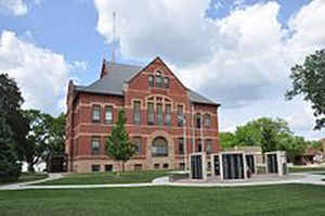
Sac County is a county located in the state of Iowa. Based on the 2010 census, the population was 10,350. Sac County was created on January 15, 1851. The county seat is Sac City. The county is named in honor of the Sac Native American tribe.
Etymology - Origin of Sac County Name
Sac county is named for the Sac Native American tribe.
Demographics:
County QuickFacts: CensusBureau Quick Facts
Sac County History
Sac County was originally attached to
Benton County. In 1851 the Legislature established the current boundaries of Sac
and attached it to Wahkaw or Woodbury County. On January 22, 1853 it was
attached to Polk County and on July 1, 1855 it was attached to Greene County for
administrative reasons. A census was taken later that same year and 251 people
were counted, enough to finally establish Sac County as an independent county.
It was formally established by law in 1856 and named for the Sac Indian tribe,
which was prominent in the area. The name means either "People of the Yellow
Earth" or "red bank."
In November 1856 the citizens of Sac County petitioned the District Court to
appoint a commission to locate the county seat. Sam H. Riddle, 7th District
Judge, appointed two men to "within two months locate the Seat of Justice as
near the geographical center as may be, having due regard for the present as
well as the future population." Later that same month the county seat was
established and named Sac City.
In the summer of 1860 a special election was held to determine the building of a
courthouse. The election called for the raising of $10,000 - via 10 percent
bonds - to be paid $1,000 annually and asked should a tax be levied. The bond
issue passed and construction was begun in the fall by W. N. Neservery of
Webster County.
By the end of the decade the citizens realized that they had built a courthouse
that was too small to handle the demands of the county. This, coupled with the
fact that the county government was changing from judges to supervisors prompted
county and township officials to campaign for a new courthouse. Several
elections failed to raise the needed support, and finally on September 6, 1869
the Board of Supervisors issued a resolution for the building of a county
courthouse at a cost of $30,000 to be completed by October 1, 1873.
This courthouse burned after a prisoner started a fire in the county jail that
spread to the courthouse. County offices were held in several buildings in Sac
City.
A small battle for the county seat followed the burning of the courthouse. A
group of businessmen from Wall Lake approached the Board of Supervisors and
offered a "substantial sum of money towards the new courthouse." The citizens of
Sac City then went to the Board with 1,745 names in support of Sac City. In the
end Sac City won out, and a new courthouse was built at the cost of $30,000,
$15,000 coming from insurance. It was completed in January 1890.
In the early 1970s two bond issues went to the voters for the building of a new
courthouse. Due to the cost and the love of the old courthouse, both failed. The
Board of Supervisors then hired architects to remodel the old courthouse and
design a new building to house a courtroom, judges, clerk of court, and
sheriff's office. This motion passed, because it was paid from the revenues from
selling off the county farm and federal money. The county offices moved into the
new addition in 1977.
Geography: Land and Water
As reported by the Census Bureau, the county has a total area of 578 square miles (1,500 km2), of which 575 square miles (1,490 km2) is land and 3.3 square miles (8.5 km2) (0.6%) is water.
Sac county is located in west Iowa. Raccoon River is located in this
county.
Neighboring Counties
Bordering counties are as follows:
- North: Buena Vista County
- Northeast: Pocahontas County
- East: Calhoun County
- Southeast: Carroll County
- Southwest: Crawford County
- West: Ida County
- Northwest: Cherokee County
Education


Click Image to Enlarge
