


Click Image to Enlarge
Nebraska Counties
There is ninety-three counties in state of Nebraska. Despite the fact that Sarpy County contained the oldest settlement in the state, it was one of the last lands along the river to be recognized by law. Finally, on February 1, 1857, the land "where the cities meet the country" was officially created.Clay County, Nebraska
Clay County Education, Geography, and History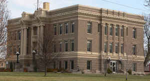
Clay County is a county located in the state of Nebraska. Based on the 2010 census, the population was 6,542. Its county seat is Clay Center. The county was formed in 1855 and later organized in 1871. It was named after Henry Clay, a member of the United States Senate from Kentucky and United States Secretary of State in the 19th century.
Etymology - Origin of Clay County Name
Named after Kentucky statesman Henry Clay.
Demographics:
County QuickFacts: CensusBureau Quick Facts
Clay County History
Like many of its neighboring
counties, Clay County's early development can be traced to the westward movement
of the pioneers who traveled the Oregon Trail in the 1840s and 1850s. In later
years the Pony Express paralleled the trail, leading to the first settlement of
the area.
John Weston established Pawnee Ranch along the Little Blue River in 1857 and it
served as one of the first Pony Express stations. Within 10 years the
Legislature defined the present boundaries of the county, naming it after
Kentucky statesman Henry Clay. A steady influx of settlers would follow,
particularly in the northern half of the county.
By 1871 the young county had progressed to the point where it had enough
residents to officially organize and elect officials. The settlement of Sutton,
which was platted by the Burlington and Missouri River Railroad on the county's
eastern border, was selected as the county seat. Within two years the county's
first courthouse was built here.
As the 1870s progressed settlers began to favor a relocation of the county seat.
Many, including those with an interest in the railroad, suggested Harvard, which
was located farther west. Sutton residents knew the impact such a move would
have on their community so efforts were quickly begun to establish a new town
located toward the center of the county. Clay Center was platted and in 1879,
despite the fact it existed only on paper, it was chosen by the voters of the
county to become the county seat. The following year a courthouse was built.
The 10 years that would follow brought tremendous growth to the county. The
railroads continued to advance their lines and more farmers came to the area to
plant corn and oats. By the end of the 1880s Clay County enjoyed a population
exceeding 16,000 residents. The growth and prosperity would be short-lived as
the drought and depression of the early 1890s caused many residents to leave the
area.
Within 10 to 15 years the local economy took a turn for the better and the 20th
century marked a return of the agricultural economy.
Geography: Land and Water
As reported by the Census Bureau, the county has a total area of 574 square miles (1,490 km2), of which 572 square miles (1,480 km2) is
land and 1.2 square miles (3.1 km2) (0.2%) is water
Neighboring Counties
Bordering counties are as follows:
- Fillmore County, Nebraska (east)
- Nuckolls County, Nebraska (south)
- Adams County, Nebraska (west)
- Hamilton County, Nebraska (north)
Education


Click Image to Enlarge
