


Nebraska State Almanac: Facts and Figures
Quick Facts, Figures, and Overview of the State of Nebraska
Nebraska is one of the West North Central states of the US. It is literally located in the heart of the United States. Nebraska encompasses a total land area of 77,354 sq. miles and is edged by Missouri, Iowa, South Dakota, Colorado, Kansas, and Wyoming. Nebraska named after the Platte River from the French meaning "broad river." The Omaha Indians called the river "iboa'pka" also meaning "broad river."
Nebraska has traditionally been known as an agricultural state. By the 1990s, although it remained one of the leading grain-producer with bumper crops of sorghum, corn, and wheat. More varieties of grass, valuable for forage, grow in this state than in any other in the nation. The state's sizable cattle and hog industries make Dakota City and Lexington among the nation's largest meat-packing centers., Nebraska had a diversified economy, dominated by services and manufacturing as well. Manufacturing has become diversified: Firms making electronic components, auto accessories, pharmaceuticals, and mobile homes have joined such older industries as clothing, farm machinery, chemicals, and transportation equipment. Oil was discovered in 1939 and natural gas in 1949.
Nebraska Almanac: Facts on the State of Nebraska |
|||
|---|---|---|---|
| Official Name | Nebraska | ||
| Capital | Lincoln | ||
| Nicknames | Cornhusker State (1945), Tree Planters State ...and more | ||
| Motto | Equality before the law | ||
| Location Region |
40.81640 N, 096.68817 W Great Plains Midwest Northwestern |
||
| Constitution Ratified | October 12,1875 | ||
| Statehood | March 01, 1867 37th state |
||
| Population | 1,826,341 (2010) 22.26 sq. mi. 38th |
||
| Largest City (by population) |
10 largest cities (2010 est.):Omaha, 408,958; Lincoln, 258,379; Bellevue, 50,137;
Grand Island, 48,520; Kearney, 30,787; Fremont, 26,397; Hastings, 24,907; North Platte, 24,733; Norfolk, 24,210; Columbus, 22,111 |
||
| Bordering States | North: South Dakota East: Iowa and Missouri (Missouri River forms the Eastern boundary) South: Kansas South West: Colorado West: Wyoming |
||
| Major Industry | farming (corn, soybeans, wheat, sorghum), grain processing, meat-packing the Air Force Strategic Air Command, | ||
| Major Rivers | Missouri River, Niobrara River, Platte River, Republican River | ||
| Major Lakes | Lewis and Clark Lake, Harlan County Lake, Lake C.W. McConaughty | ||
| Nebraska Counties | 93 Counties in Nebraska | ||
| Largest County (by population) |
Douglas County 517,110 (2010) 331 sq. mi. |
||
| Largest County (by area) |
Cherry County 5,961 sq. mi. |
||
| State parks | 87 | ||
| Presidential Birthplace | Gerald Rudolph Ford was born in Omaha on July 14, 1913 (he was the 38th US President, serving from 1974 to 1977). | ||
| Electoral Votes | 5 | ||
| US Congress | 2 Senators; 3 Representatives | ||
| Time Zone | Central Standard Time | ||
| Zip Codes | NANPA | ||
| State Quick Facts | Census Bureau Quick Facts | ||
Nebraska Climate and Weather |
|
|---|---|
| Nebraska enjoys warm summers, generally dry winters, moderate
humidity and plenty of sunshine. Early evening thunderstorms are common in summer, especially central and east. Tornados strike the state
on a regular basis as Nebraska is in America's Tornado Alley January is the coldest month, with average high temperatures near 20 degrees. July is the warmest month, with average high temperatures near 80 degrees. Much hotter summers and harsh, cold winters are not uncommon. Annual precipitation amounts range from 20 - 30 inches in the east and central, while the west has much drier conditions. |
|
| Highest Temperature | 118 degrees July 24, 1936 - Minden |
| Lowest Temperature | -47 degrees February 12, 1899 - Camp Clarke |
| Avg. Temp: High - Low |
89.5 degrees - 8.9 degrees |
Nebraska Points of Interest |
|
| Chimney Rock Historic Site; the State Capital Building in Lincoln and the University of Nebraska; Omaha and it numerous cultural events and family entertainment options; Scotts Bluff National Monument, Agate Fossil Beds, Homestead, and Scotts Bluff National Monuments; Chimney Rock National Historic Site; a recreated pioneer village at Minden; SAC Museum near Ashland; the Stuhr Museum of the Prairie Pioneer Grand Island; Boys Town; the Sheldon Memorial Art Gallery and the Lied Center for the Performing Arts at the University of Nebraska in Lincoln; the State Capitol in Lincoln; the Joslyn Art Museum in Omaha; the Henry Doorly Zoo in Omaha; Museum of Nebraska Art in Kearney; Museum of Nebraska History in Lincoln; and the University of Nebraska State Museum in Lincoln and much, much more. | |
Nebraska Highest, Lowest, and Mean Elevations (Feet) |
|
| Mean Elevation: 2,600 feet | |
| Highest Point: Panorama Point; Johnson Township, Kimball County: 5,424 feet
|
|
| Lowest Point: | Missouri River 840 feet |
Nebraska Land Area (Square Miles) |
|
| Geographic Center | In Custer County, 10 mi. NW of Broken Bow Longitude: 99°51.7'W Latitude: 41°31.5'N |
| Total Area | 77,353.73 sq. mi. 16th |
| Land Area | 76,872.41 sq. mi. 99.38% |
| Water Area | 481.31 sq. mi. 0.62% |
| Forested Land Area | 1.9% |
| Dimensions (Length - Width) |
430 miles - 210 miles |
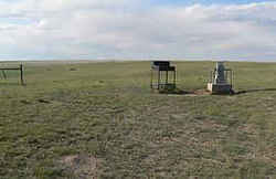 In
the extreme southwest corner of the Banner County, thirty three miles from Kimball, rises the highest point in Nebraska overlooking three states,
Nebraska, Colorado and Wyoming. This site, 5,424 feet above sea level, looks more like a rise in a pasture than the highest point in the state.
In
the extreme southwest corner of the Banner County, thirty three miles from Kimball, rises the highest point in Nebraska overlooking three states,
Nebraska, Colorado and Wyoming. This site, 5,424 feet above sea level, looks more like a rise in a pasture than the highest point in the state.Adams, Antelope, Arthur, Banner, Blaine, Boone, Box Butte, Boyd, Brown, Buffalo, Burt, Butler, Cass, Cedar, Chase, Cherry, Cheyenne, Clay, Colfax, Cuming, Custer, Dakota, Dawes, Dawson, Deuel, Dixon, Dodge, Douglas, Dundy, Fillmore, Franklin, Frontier, Furnas, Gage, Garden, Garfield, Gosper, Grant, Greeley, Hall, Hamilton, Harlan, Hayes, Hitchcock, Holt, Hooker, Howard, Jefferson, Johnson, Kearney, Keith, Keya Paha, Kimball, Knox, Lancaster, Lincoln, Logan, Loup, Madison, McPherson, Merrick, Morrill, Nance, Nemaha, Nuckolls, Otoe, Pawnee, Perkins, Phelps, Pierce, Platte, Polk, Red Willow, Richardson, Rock, Saline, Sarpy, Saunders, Scotts Bluff, Seward, Sheridan, Sherman, Sioux, Stanton, Thayer, Thomas, Thurston, Valley, Washington, Wayne, Webster, Wheeler, York

