


Click Image to Enlarge
Nebraska Counties
There is ninety-three counties in state of Nebraska. Despite the fact that Sarpy County contained the oldest settlement in the state, it was one of the last lands along the river to be recognized by law. Finally, on February 1, 1857, the land "where the cities meet the country" was officially created.Custer County, Nebraska
Custer County Education, Geography, and History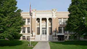
Custer County is a county located in the state of Nebraska. Based on the 2010 census, the population was 10,939. Its county seat is Broken Bow. The county was formed in 1877 and named after General George Armstrong Custer, who was killed at the Battle of Little Bighorn.
Etymology - Origin of Custer County Name
The county was named in honor of Gen. George A. Custer, who was killed the preceding summer.
Demographics:
County QuickFacts: CensusBureau Quick Facts
Custer County History
Located in the geographic heart of
the state, Custer County features a diverse blend of topography. Nearly
three-quarters of the county is in the state's corn belt, while the northwest
one-quarter is considered part of the Sandhills. Consequently, corn and cattle
production are the dominant contributors to the county's present day economy.
The organization of Custer County was officially approved on Feb. 17, 1877. This
came after a group of 13 ranchers and settlers sent to the governor a signed
petition asking that the territory be formed into a governmental body. The
county was named in honor of Gen. George A. Custer, who was killed the preceding
summer.
Only a handful of settlers came to the area in the years leading up to the
1870s. Since the region was virtually uninhabited, these settlers were able to
amass enormous ranches. Eventually, more and more homesteaders came to the area,
fenced in their land, and planted crops. With the tremendous cattle losses
during the winter of 1880-81, the ranchers gave way to thousands of homesteaders
coming to the area after the Civil War. Sod houses and small settlements quickly
began to replace the vast ranches.
The first courthouse was a cedar log, two-room, L-shaped structure that was
built in 1876 on the Young Ranch near the South Loup River. It was used from the
time the county was organized in 1877 until Broken Bow was named the county seat
after a special three-way election.
People often inquire how the county seat received its unique name. According to
historians, Wilson Hewitt was postmaster for the area at the time and had
suggested three names. Shortly after the third was rejected, Hewitt's two sons
showed him a broken Indian bow they had found on the banks of nearby Muddy
Creek. Hewitt suggested Broken Bow and it was quickly accepted by the post
office department.
A red brick, ornate courthouse with rounded towers on the corners was build in
1889. It was destroyed by fire in 1910. Two years later, the county's present
courthouse was constructed on the same site.
Geography: Land and Water
As reported by the Census Bureau, the county has a total area of 2,576 square miles (6,670 km2), of which 2,576 square miles (6,670 km2)
is land and 0.4 square miles (1.0 km2) (0.01%) is water. In area, it is the second largest county in Nebraska, behind only Cherry County.
Neighboring Counties
Bordering counties are as follows:
- Valley County (northeast)
- Sherman County (southeast)
- Buffalo County (southeast)
- Dawson County (south)
- Lincoln County (southwest)
- Logan County (northwest)
- Blaine County (northwest)
- Loup County (northeast)
Education


Click Image to Enlarge
