


Click Image to Enlarge
Nebraska Counties
There is ninety-three counties in state of Nebraska. Despite the fact that Sarpy County contained the oldest settlement in the state, it was one of the last lands along the river to be recognized by law. Finally, on February 1, 1857, the land "where the cities meet the country" was officially created.Dakota County, Nebraska
Dakota County Education, Geography, and History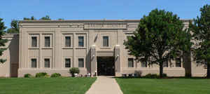
Dakota County is a county located in the state of Nebraska. Based on the 2010 census, the population was 21,006. Its county seat is
Dakota City.
Dakota County is part of the Sioux City, IA-NE-SD Metropolitan Statistical Area.
Etymology - Origin of Dakota County Name
Dakota County derives its name from the Dakota Sioux tribe. The most common interpretation of the word Dakota means allies or brothers.
Demographics:
County QuickFacts: CensusBureau Quick Facts
Dakota County History
Historical records of Dakota County
officially begin in 1862 when the area was separated from Burt County and this
new county's boundaries were defined by members of the Territorial Legislature.
But this area along the Missouri River in the northeast corner of Nebraska
actually can be traced back to the late 18th century.
According to historical accounts, a fur trading post known as Fort Charles was
established along the river in 1795, long before the area would become Dakota
County. Some historians claim this trading post was the first business to be
located within the area that would become the State of Nebraska a full 72 years
later.
Roughly 50 years before the first county boundaries were established, Meriwether
Lewis and William Clark passed through the area during their journey up the
Missouri River. At the time the area was primarily known only to members of the
Dakota tribe.
The original county boundaries in this area of the state were actually created
in 1855. The following year the Territorial Legislature named the Missouri River
settlement of Dakota City as the county seat. In 1858 some settlers in the area
sought to relocate the county seat to a more central location. An election was
held, with St. John's challenging Dakota City for the honor. When the votes were
counted the final tally read 263 for St. John's and 260 for Dakota City. Since a
majority to relocate the county seat was not achieved, it remained in Dakota
City.
Early settlers included William James, who in 1871 became Secretary of State,
and John Taffe, who would later go on to serve in Congress.
The first courthouse was built in Dakota City in 1870. Seventeen years later the
townsite of South Sioux City was incorporated several miles to the north. In the
years that followed, South Sioux City made several attempts to become the county
seat but each time Dakota City prevailed.
Geography: Land and Water
As reported by the Census Bureau, the county has a total area of 267 square miles (690 km2), of which 264 square miles (680 km2) is land
and 3.2 square miles (8.3 km2) (1.2%) is water. It is the second-smallest county in Nebraska by area.
The county is separated from South Dakota on the northeast and Iowa on the east by the Missouri River. The surface consists of rolling
prairies and bottom lands
Neighboring Counties
Bordering counties are as follows:
- Union County, South Dakota - north
- Woodbury County, Iowa - east
- Thurston County, Nebraska - south
- Dixon County, Nebraska - west
Education


Click Image to Enlarge
