


Click Image to Enlarge
Nebraska Counties
There is ninety-three counties in state of Nebraska. Despite the fact that Sarpy County contained the oldest settlement in the state, it was one of the last lands along the river to be recognized by law. Finally, on February 1, 1857, the land "where the cities meet the country" was officially created.Fillmore County, Nebraska
Fillmore County Education, Geography, and History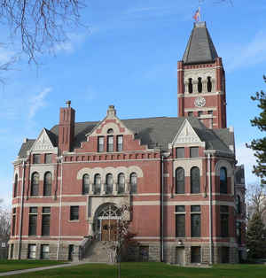
Fillmore County is one of 93 counties in the state of Nebraska. Based on the 2010 census, the population was 5,890. Its county seat is Geneva. The county was named for President Millard Fillmore.
Etymology - Origin of Fillmore County Name
A "veritable Eden" was the description used to attract early settlers to the area that is now Fillmore County.
Demographics:
County QuickFacts: CensusBureau Quick Facts
Fillmore County History
In 1871 the Burlington and Missouri
River Railroad completed its line that paralleled the west fork of the Big Blue
River. Company officials immediately began advertising in Eastern newspapers
that a "veritable Eden" awaited anyone who wanted to homestead on the Nebraska
plains. Glowing testimonies told of ample water and fuel, rich land, and, of
course, easy access to the rail line. These advertisements brought hundreds of
settlers to the area. Some found it to be as advertised; others did not and
quickly returned to the East, discouraged and disheartened.
The influx of settlers hoping to make their fortune from the land brought in the
necessary number of inhabitants needed to officially organize the county, which
had been named after President Millard Fillmore when the boundaries were
established 15 years earlier. On March 15, 1871, acting Gov. William H. James
decreed that a county election would be held the following month. It was decided
during that election that a site near the center of the county should be named
the county seat.
County commissioners met for the first time later than summer in a dugout
located on the land of Col. J.A. McCaully. During the meeting they discussed
possible locations for a county seat and McCaully's young daughter, Emma,
suggested it be named Geneva, after the town in New York from where the family
had come. Thus, the future county seat of Geneva was established on the McCaully
farm.
The sale of land at this new townsite took place in June 1872, a year after it
had been surveyed. In a general election held in November of that year,
residents of the county approved a tax for the purpose of building a wood frame
courthouse and jail. By February 1873 the jail was completed. Three months later
the courthouse was finished and it would serve county residents for 20 years. It
was replaced when the present courthouse was completed in 1893.
Geography: Land and Water
As reported by the Census Bureau, the county has a total area of 577 square miles (1,490 km2), of which 575 square miles (1,490 km2) is
land and 1.2 square miles (3.1 km2) (0.2%) is water
The county lies entirely within the watershed of the Big Blue River. Water in the county drains via the West Fork of the Big Blue; via Turkey
Creek, which runs into the Big Blue near De Witt, Nebraska; and via the Little Blue, which joins the Big Blue in Kansas.
Fillmore County lies within the eastern portion of Nebraska's loess plain, a region of soil deposited by the wind during a period between
25,000 and 13,000 years ago, forming a plain that slopes gently downward to the southeast. The Big Blue and its tributaries have incised
channels into the loess surface in places, but in much of the county the original plain remains. These loess-plain regions are characterized
by extensive upland flats with shallow depressions. The depressions are lined with fine-grained and relatively impermeable silt, and tend to
form shallow ephemeral wetlands when filled with rain or snowmelt; such wetlands range in area from less than 40 acres (16 ha) to more than
500 acres (200 ha).
The surface of the county is underlain by Cretaceous sedimentary bedrock, topped with unconsolidated Quaternary sediments. The bedrock was
eroded into hills and valleys before the deposition of the overlying sediments, so the thickness of the latter varies. The unconsolidated
sediments range in thickness from 60 to 450 feet (18 to 137 m); they form an aquifer whose saturated zone ranges in thickness from 20 to 350
feet (6.1 to 106.7 m).
Neighboring Counties
Bordering counties are as follows:
- York County (north)
- Seward County (northeast)
- Saline County (east)
- Jefferson County (southeast)
- Thayer County (south)
- Nuckolls County (southwest)
- Clay County (west)
- Hamilton County (northwest)
Education


Click Image to Enlarge
