


Click Image to Enlarge
Nebraska Counties
There is ninety-three counties in state of Nebraska. Despite the fact that Sarpy County contained the oldest settlement in the state, it was one of the last lands along the river to be recognized by law. Finally, on February 1, 1857, the land "where the cities meet the country" was officially created.Furnas County, Nebraska
Furnas County Education, Geography, and History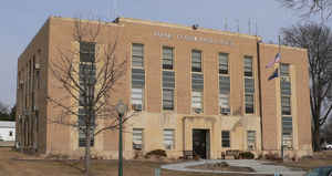
Furnas County is a county located in the state of Nebraska. Based on the 2010 census, the population was 4,959. Its county seat is Beaver City. The county was named in honor of Robert W. Furnas, the second governor of the state of Nebraska.
Etymology - Origin of Furnas County Name
When Robert W. Furnas became governor in 1873, the Legislature adopted an act to organize an area along the Kansas border and name this latest county in his honor.
Demographics:
County QuickFacts: CensusBureau Quick Facts
Furnas County History
The pride and enthusiasm that early
settlers placed in locating the seat of local government was possibly nowhere
more evident than in Furnas County. Events there showed just how strong the
emotions could become.
When Robert W. Furnas became governor in 1873, the Legislature adopted an act to
organize an area along the Kansas border and name this latest county in his
honor. The influx of settlers that had preceded the Legislature's action had
already resulted in the settlements of Arapahoe and Beaver City being
established. So when the county's first organization election was held on April
8, 1873, ballots were cast at both sites.
Election results from Arapahoe were filed with the Secretary of State's office
within the appointed time limit. The returns from Beaver City, however, were
delayed en route to Lincoln because of a heavy snowstorm. As a result, Beaver
City's ballots did not arrive until after the day on which the ballots were
counted. The Secretary of State issued certificates of election of officials in
Arapahoe and ruled that settlement to be the county seat. What followed was a
series of court orders and bitter political fights between the settlers in the
north and south parts of the county.
A court quickly ordered the Secretary of State to canvass the Beaver City votes
and issue certificates of election to the candidates who received the highest
vote from the combined returns of Arapahoe and Beaver City, and to designate as
the county seat the site that received the greatest vote
A second election was held the following October. This time, Beaver City was
declared the victor. Inhabitants of Arapahoe continued to claim victory based on
the April election. It took three years of legal challenges before the Supreme
Court ruled that Beaver City was indeed the county seat. Continued dissention
delayed the building of a courthouse until 1888.
The first courthouse stood for 60 years before being declared unsafe for
occupancy in 1948. The courthouse was dismantled the following year and after
the county offices were housed in various downtown buildings for two years, the
current courthouse was dedicated on May 4, 1951.
Geography: Land and Water
As reported by the Census Bureau, the county has a total area of 721 square miles (1,870 km2), of which 719 square miles (1,860 km2) is
land and 1.5 square miles (3.9 km2) (0.2%) is water
Neighboring Counties
Bordering counties are as follows:
- Harlan County (east)
- Norton County, Kansas (south)
- Decatur County, Kansas (southwest)
- Red Willow County (west)
- Frontier County (northwest)
- Gosper County (north)
- Phelps County (northeast)
Education


Click Image to Enlarge
